The Ancient Waterstock Parish covered only 653-acres. It lay in a bend of the River Thame which Bounded it on the North & West; on the East its Boundary followed a Brook and then continued with several right-angled turns along what was probably the Line of Furlongs in the Open-fields. Large Hedgerow Elms formerly marked its Course. The Draycott Road also marked a part of the Eastern Boundary. The Thame-Oxford Road & the Main London-Oxford Road which it joins formed the Southern Boundary of the Parish.
The Lower Section of the River Thame runs from the Town of Thame to its Confluence with the River Thames just South of Dorchester-on-Thames: a distance of about 52-km. From Thame Town, the River Flows broadly West past the Villages of Shabbington & Ickford to Waterstock. It then turns to the South now passing under the M40 & A40 Junction & Services at Wheatley, past Cuddesdon Mill & Chiselhampton, (where it is joined by the Chalgrove Brook) before continuing on to Dorchester.
Natural History of Oxfordshire ~ Robert Plot

Michael Burghers – Map Of Oxfordshire 1677
Beautifully embellished Map of the County of Oxfordshire engraved by Michael Burghers for Dr Robert Plot’s “The Natural History of Oxfordshire” Published in 1677, a Work that contained descriptions & images of Fossils found in the County including the 1st known illustration of a Dinosaur bone. The defining characteristic of the Map is the extensive decoration of the Borders & Cartouches with 178–Coats of Arms of the Colleges of Oxford University, Noblemen & Clergy. Also included is a Key explaining the Symbols used to identify various types of Locations on the Map.
In 1886 the Parish was enlarged by the addition of Tiddington Mead (11-a), formerly in Albury Parish, by Draycott Village & by 250-acres from the Oxon part of Ickford Parish. Thus Waterstock’s Eastern Boundary mainly followed the Ickford Road. In 1954 Draycott Village with 60-acres was transferred to Tiddington-with-Albury & Waterstock’s acreage was reduced to 903-acres.
OS Map 1919 Sth Oxon XL.4 (Tiddington; Waterstock)
The Soil is Gravel & Loam on Kimmeridge Clay & Alluvial Soil is found in the Meadows bordering the River Thame. The Parish is low-lying & is mostly within the 200-ft Contour, is liable to Floods in the North-west & rises to 225-ft in the South-East only.
The main approaches to the Village have probably always been from the South by the Road leading from the Thame-Oxford Road (A408), or from the East by the Tiddington-Ickford Road. It is possible that the 1st of these was the 17thC ‘Gysgire‘. In the early-17thC there are several Documentary records of Lincroft Bridge near some Ley-ground & to Lincroft which is shown on a 17thC Sketch Map. The name, in fact, goes back to the 12thC. There does not seem to have been a Stone Bridge over the River Thame until in 1790 Diana Ashhurst Built the present Bow Bridge & a Carriage Road over Little Mill Meadow to connect with Curson’s Carriage Road from Waterperry House & Bridge over Back Ditch. The Bridge has a Single Brick Arch & solid Outcurving Parapets with a Stone Coping.
Waterstock’s nearest Railway Station was at Tiddington. The Wycombe & Oxford Railway, running except for one short stretch to the South of the Parish Boundary, was Opened in 1864. It absorbed 15-acres of Hedges Great Ground, which was paid for at the rate of £200 an acre.
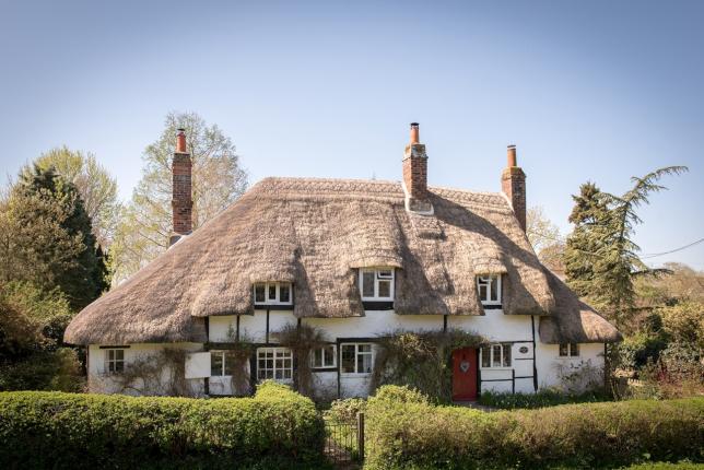
The Village stands near the River about 200-ft up and centres around its Church & Manor-House. Long Ownership in one Family has resulted in a well-preserved Village, mainly composed of 17th & 18thC Farmhouses & Cottages, Built of Local Brick. It has never been large, but except for a short Period in the 19thC it seems to have been more populous in the Middle-Ages than it has ever been since. Some 18-Householders were Listed for the Hearth Tax of 1662 & in the 18thC, about 15 to 17 Houses were recorded. In 1665 there were 4 substantial Farmhouses with 2 to 6-Hearths apiece besides the Big House & smaller Houses. Many of these Houses still survive. The oldest Dwellings in the Village are 4-Timber-framed Elizabethan or early-Jacobean Cottages: they are of Brick Construction & are Built in pairs on opposite sides of the Road. Their Hipped Roofs of Thatch are swept down at the ends over 1-Storey Extensions. They have irregularly spaced Casement windows that are mostly Leaded.
Richard Davis’s Map Of Oxfordshire 1797
Two of the Ancient Farmhouses in the Village Street are still used as such: Home Farm & the adjoining Park Farm. The 1st is L-Shaped & dates mainly from the 17th & 18thCs. The 17thC Wing is at Right angles to the Road & consists of 2-Storeys; it is Timber-framed with Brick Infilling & the Tiled Roof is half-Hipped at the end Fronting on the Road. The North-west Elevation of this Wing has a Timber-framed Gable to the right hand, a Rectangular Chimney-Stack to the left hand & 1–Gabled Dormer window. The Wing to the North-west is Built of 18thC Brick & has a Tiled Roof. Home Farm has an Ancient Thatched Barn & a 17thC Granary which is Built of Brick & Timber.
Waterstock Parish Tithe Map 1838
Park Farm is a House of 2-Builds: it stands back from the Road & appears to be of 18thC date, although it may incorporate some of an older Building. The West front has 3-Bays & is of Ashlar Stone. Members of the Bull Family have been Tenants of both these Farms for several Generations. The Farmhouse, once Church Farm, lies opposite the Church, but it is now 3-Cottages. It dates from the early-18thC & is a 2-Storey House of Rubble facing North. It has Casement windows, mostly of 4-lights with Mullions & Transoms of Wood & Leaded Panes; a 6-panelled Door and a Low Stone Wall separating it from the Street. The Schoolhouse (now 2-Cottages) & the Cottage for a Schoolteacher next Door also date from the 18thC. The School has a Beam with the date 1751 on it.

There have been some 19th & 20thC additions: some Cottages of Red Brick with Slate Roofs, the Stone Pump-house at the entrance to the Manor, dated WHA 1898 & a War Memorial that was Erected on the small Green after WW1. The Pond which used to be at the Cross Roads has been filled in, but the Stream running beside the Road to Home Farm remains. No Council Houses have been Built in the Village.
The Manor-House has experienced a number of re-Buildings. Nothing of the Medieval House now survives, but as it was successively lived in by several important Families of Oxon Gentry it must have been a House of some size. The Bruleys inhabited it in the 13th & 14thCs and the Danvers Family in the 15thC. John Danvers and his wife were given Papal Licence to have a Portable Altar to be used for the saying of Mass for themselves & their Household. At the end of the Century Thomas Danvers brought distinction to the Village: he was a Member of 3-Parliaments & also actively assisted in the Foundation of Magdalen College, for he was the friend of Bishop Waynflete & the New Learning. It was from his Waterstock House that Danvers wrote in 1494 to President Mayhew of Magdalen College telling that he was busy with the Affairs of the College & other Learned Institutions & that he was in Communication with the King & the King’s Mother Margaret, Countess of Richmond. The Windows of the House were decorated with Heraldic Glass, for in his Account of the Painted Glass still there in the 17thC, Anthony Wood (Antiquary) mentions the Arms of Danvers & the related Families of Bruley & Verney. Later the House was occupied by the Cave’s and then by the Croke’s. Some details of the Building in Sir George Croke’s day are known. It was by then one of the Larger Houses in the County and was Taxed on 23–Hearths in 1665. The Arms of Croke & related Families as well as of Danvers were in the Windows of the Upstairs Drawing-room, the Great & Little Parlours & the Hall. Dr Robert Plot (Antiquary) shows the House on his Map of Oxfordshire, & in his account of unusual Trees cultivated in the County he mentions the Abele Tree (White Poplar grown by Sir George Croke, that ‘Learned & Curious Botanist‘, who was one of the earliest Members of the Royal Society.

The Crokes were strong supporters of the Parliamentary Cause & when General Ireton wrote from Waterstock on 16th April 1646, about his preparations for the Siege of Wallingford, it may be supposed that he had his Headquarters at the House of George Croke, a friend of Baxter & Hampden. This House was pulled down in 1695 & was replaced by a Red-Brick one in the time of Sir Henry Ashhurst. The New House, begun in 1695, was being completed in 1696 when Mr Thomas Hodges, Joiner, of St Dunstan’s, Stepney, was Commissioned to Wainscot the Hall & Passageway leading to the South-West part of the Mansion. He undertook to use ‘good dram stuff‘; to make & fix handsome Stone Mouldings round the Windows of the Hall & ‘breakes‘ in the Cornice over each of the windows; to make & fix a 7-Penny Cornice round the Hall; make Doors of 8 or 10 Panels with 6-inch Stone Moulding around the Door cases, ‘Pullexions to be laid into both sides‘. He was to be paid 3s a yard for most of the work, but 2s-4d for the Wainscot in the Passage. In 1787 Sir Henry Ashhurst, the Eminent Judge took down this Building & erected a new Mansion of Stone rather higher up the Slope above the Church. The Foundation Stone was Laid in 1787 & the Family moved in in 1791. According to a Manuscript Memorandum among the Family Papers, the Architect was ‘Sir Richard Coucerell‘, presumably an error for S P Cockerell (1754-1827).
In 1787-91 Sir William Henry Ashhurst, Kt. replaced the late-17thC House with a new 3-Storey Stone Block rather higher up the Slope above the Church. The New Building was rectangular with an Entrance Front of 5 widely spaced Bays & severely plain side Elevations of 5-Bays. The Garden Front had window spacing to match the Side Elevations, resulting in a 6-Bay Facade on this Side. On the Entrance front, the Pedimented Central Bay projected & had a 6-Panelled Door in a Doric Surround with Sidelights & an Arched Fanlight, with a Venetian Window with engaged Ionic Columns on the 1st-Floor. The only other decoration on the House was provided by a Plat Band at the 1st-Floor Level, a Modillion Cornice & Quoins at the angles.

Waterstock House: The South-east & Entrance Front were of 5-Bays with the Centre Bay and its Pediment slightly Projecting. The Entrance on the Ground Floor was by a double 6-panelled Door in a Doric Surround with Sidelights & a Stilted Arched Fanlight. On the 1st-Floor there was a central Venetian window with engaged Ionic Columns. There was a String-course at the 1st-Floor Level & a Modillioned Cornice and a Hipped Roof of Slate. The Wall swept up in the North-east corner to a Square Garden-house. Sir Henry Ashhurst improved & enlarged his Garden by taking part of the Churchyard in exchange for certain Undertakings to the Rector: it was perhaps in his day that the Bricks from the Old House were used for making the Walled Garden. It was, however, in 1807/8, in the time of his son W H Ashhurst, that the Grounds were Laid out ‘under the direction of Sir John Hopper‘ (presumably the Architect Thomas Hopper is meant). The Ornamental Water shown on the Tithe Map of 1848 may belong to this date. The 18thC House was pulled down in 1953, owing to the expense of its Upkeep, after the Servants’ Quarters, a Square Stone Building of 2-Storeys attached to the Main House by a Corridor, had been Converted in 1953 by Major & Mrs Ruck-Keene into a Modern Dwelling. By the Entrance to Waterstock House was the Pump House dated 1898, a small Building with a “Rhenish Helm” Roof reminiscent of a Saxon Tower. Many of the Villagers used to collect Water from it until the Village’s Mains Water Supply was installed in 1951.


Their House is of 4-Bays and has a Single-Storey extension to the left hand. The Stone Cartouche of Arms, formerly over the Central Door of the Stable Courtyard, is above the Entrance Door; a Marble Mantlepiece, moved from the Old Mansion, is in the Drawing-Room; & the Staircase is a Copy, on a reduced scale, of the Georgian Staircase of the Old Mansion. The Builders were Hinkins & Frewin Ltd of Oxford. The Stables, Built in the form of a Courtyard & lying to the South-east of the old Mansion & the present House, remain. They are Built of Stone & are probably contemporary with the 1787 House. They are entered through Stone Gate Piers. Many of the Houses in Waterstock have their own Stables. Waterstock House Training Centre was once the main Equestrian Centre of the Area & was once Owned by the Horse Trainer Lars Sederholm

The only other Gentleman’s House in the Village is the Old Rectory. It was repaired in 1787 by Mrs Ashhurst, the mother of Sir Henry, for the New Rector, R B B Robinson. In the Main it is an 18thC Stone House of 2-Storeys, but an Older Wing remains. The South-west Front is of 3-Bays. The 19thC Bay Window extending from the Ground Floor to the 2nd Floor was added before 1857. The Veranda with Pent Roof across the Front is also later. The House had a well-laid-out Garden with some fine Trees, which include a Female Gingko a Native of China. In the 20thC it was the home of the Armenian Concert Violinist Manoug Parikian, his wife Diana the Antiquarian Bookseller, and their 2-sons, until his sudden death on Christmas Eve 1987. He is Buried in St Leonard’s churchyard.

Away from the Village Street and approached by a Road across the Fields is the Picturesque Mill-house on an Island in the River Thame. It is in origin a 15thC House but has been re-Built in the Elizabethan Period. Its Plan is L-shaped: it is Timber-framed with Brick Filling & has 2-Storeys. In the South Front there is one half-Hipped Gable to the left hand, and 2-Gabled Dormer windows to the centre & right. The Casement windows & Entrance Door are irregularly spaced. Inside, one of the Timber Beams has the Initials of Sir Henry Ashhurst Carved on it and the date 1693. All the Timber used is uncut Tree Trunks. The oldest part of the House is the Stonewalling in the South-west corner. Waterstock Mill is recorded in the Domesday Book of 1086.

The Village has been associated with a number of Families of Interest who Held the Lordship and Resided at the Manor-House. The Ashhursts who were Resident from 1691 to the mid-20thC may, perhaps, be specially mentioned. An event of minor importance, but of some Local Interest, occurred in 1695 when Sarah Smith, the sister-in-law of the Vicar, Charles Hinde, married in Waterstock Church White Kennett, then Vicar of Ambrosden, but later to be distinguished by high preferment in the Church and as the Author of Parochial Antiquities in the Counties of Oxford & Bucks.
Orchard End Is a Grade-II Listed Cottage – Orchard End was studied by the Medieval Historian John Blain (Oxoniensia vol. XLIV 1979) and at the time, it took approximately 40-Elm Trees to Build this Property. The Original Walls were of Wattle & Daub but some of the Exterior Walls have been replaced by Brick or Stone. A previous Owner was the renowned Local Artist Cicely Osmond-Smith.
The Cottage still retains its Period features such as:
Exposed Beams, Inglenook Fireplace & Wooden Doors and has Flagstone Floors throughout the Ground Floor. The Front Door leads into a Snug with a Fireplace, Stairs leading up to the 1st-Floor & Doors to Service Rooms. The Dining Room, which is dual aspect, has a 2nd Staircase leading to Bedrooms. Upstairs are 3-Bedrooms. Outside, the Front & Rear Gardens are mainly laid to Lawn, with Gravel Paths & Flower Borders and mature Shrubs & Trees.

Oxfordshire Way
Waterstock to Tiddington – 1.5 miles (pdf format, 282 KB)

“Waterstock is a hidden Jewel in the Crown of the River Thame.”

