
1768 Estate Map of Aston Rowant
Based on an Estate Map of (1768), the Inclosure Award (1832), the Tithe Award (1842) & a Kingston Blount Schedule (1829) & Leases (Bodleian Library Ms. d.d. Clerke Brown c 2/9, etc.) from which the approximate position of the Kingston Fields has been plotted.
The Rural Landscape of England & Wales in the 184o’s is depicted exactly in the Field-by-Field Surveys carried out by the Tithe Commissioners. Their enquiries covered about 75% of the Country. The Maps drawn for each Parish show the Boundaries of Fields, Woods, Roads & Streams, and the position of Buildings, while the accompanying Schedules give the names of their Owners & Occupiers, their State of Cultivation & their Area. The amount of detailed information they provide about Land Tenure, Field Systems & Land Use is unequalled by any other Series of Documents. Their accuracy is sufficient to Warrant their continued use as Evidence in Courts of Law on matters not directly connected with the Payment of Tithe. Their uniformity & comprehensiveness are surpassed only by the Land Utilisation Survey of the 193os. Indeed, they Rank as the most complete Record of the Agrarian Landscape at any Period.
The Ancient Parish of Aston Rowant was exceptionally Large for an Oxon Parish: it then included most of the Modern Parish of Stokenchurch & must have covered an Area of about 7,298-acres. It stretched for about 6-miles from the Northern end of Lewknor Hundred to the Hundred’s Southern Boundary with Bucks & contained the Hamlets of Copcourt, Chalford & Kingston Stert in the North; Aston Rowant itself & the large Village of Kingston Blount in the Centre; the Hill Village of Stokenchurch & its Hamlets at Beacon’s Bottom & Water End in the South. In 1895 Stokenchurch, which was a separate Civil Parish by this time, was transferred to Bucks. Thus Aston Rowant’s Southern Boundary, although still the County Boundary, now runs to the North of Stokenchurch & its area has been reduced to 2,924-acres. Its only natural Boundaries are the small Streams in the North & East, whose Courses are followed as they Flow Northwards to the River Thame. One of these is the Holbrook which is frequently referred to in 16th & 17thC Deeds & in which the Lords of Aston Manor had Fishing Rights.
Richard Davis’s Map Of Oxfordshire 1797
Map of Oxfordshire by Phil Overton 1715
In 1055 the Diocese of Winchester held the Manor of Aston Rowant. Bishop Stigand of Winchester had promised to Grant Aston Rowant to the Benedictine Abingdon Abbey but failed to do so. Just before the Norman Conquest of England a Saxon called Wulfstan Held the Manor. The Domesday Book records that in 1086 Estone (East Tun or Aston Rowant) belonged to Prominent Norman Baron Miles Crispin, son-in-law of Robert D’Oyly. Crispin died in 1107 & his Widow Maud was married to Brien FitzCount. FitzCount & Maud supported Empress Matilda during the Anarchy & when King Stephen defeated Matilda both FitzCount & Maud entered Religious Houses, the latter to Wallingford Priory to whom the Grant of the Church (Churchlands & Advowson) was made, subsequently appointing its Vicar until the Dissolution of the Monasteries. Stephen gave their Estates to Henry, Duke of Normandy, thus making Aston Rowant part of the Honour of Wallingford. Aston Rowant later became part of the Honour of Ewelme.

Miles Crispin (d.1107), also known as Miles or Milo of Wallingford, was a wealthy Norman Landowner, particularly Associated with Wallingford Castle in Berks (now Oxon). The Domesday Book records Miles as a Major Landowner with Holdings in Berks, Bucks, Oxon, Surrey, Wilts & 2-other neighbouring Counties as well as being Tenant-in-Chief in a lengthy List of Places. Miles is believed to be a Member of the Crispin Family of Neaufles in Normandy: suggestions include son of William Crispin, Baron of Neaufles (Neaufles-Saint-Martin or Neaufles-Auvergny), part of William the Conqueror’s Invading Force & a Relation of Gilbert Crispin, Abbot of Westminster, but this is uncertain. Miles married Matilda, daughter of Robert D’Oyly, in 1084. While D’Oyly is generally credited with Building Wallingford Castle, it has also been suggested that Miles Crispin was its 1st Castellan of Wallingford & Owner of the Lands of Wigod. Matilda later married Brien FitzCount. During the Rebellion of 1088, Miles Crispin was a Supporter of William II & was in the Army that later Arrested William de Saint-Calais.

To the North of Aston, the Land is mostly within the 200/300-ft Contour, but Prospect Hill (or Briar’s Hill as it was called in the 19thC) in the extreme North-west of the Modern Parish rises to 300-ft. This Landmark, which was planted with Douglas Firs by 1878, may well be the Old English ‘Trendle‘ or ‘Trindhulle‘ meaning Roundhill, recorded in the 13thC. In the South, the Crest of the Chiltern Ridge rises to 800-ft above Hill Farm. Part of Aston Hill was given to the National Trust in 1956 & 70-acres on Beacon Hill were made a Nature Reserve in 1958. The Northern Triangle of the Parish lies on Gault, the Centre is mostly on the Lower Greensand & the Upper Fields & Hill Slopes on Chalk.


Map of the County of Oxford, from Actual Survey, by A Bryant, in the Year 1823. Inscribed by permission to the Rt Honourable the Earl of Macclesfield, Lord Lieutenant, and to the Nobility, Clergy & Gentry of the County. (Click Zoom Button to enlarge)
Coaching In & Out of Oxford
The Road System has seen a number of changes. The Main London Road forms a short part of Aston’s Western Boundary; it was known as Via Regis or ‘London Weye‘ in the Middle-Ages & became a Turnpike in 1718. At that time it passed the present Warren Farm which was the original ‘Drum & Plough’ Inn in the 18thC, but in 1824 this Route was ‘found inconvenient‘ & was diverted to the West so as to be more ‘commodious to the Public‘. The new Turnpike, (which was de-Turnpiked in 1877) & the old Turnpike are shown on an Estate Map of 1828. An important Minor Road in the 18thC, but now no longer used, branched off the Main Road South of Tetsworth, ran through Copcourt, along Copcourt Church Way to Aston & then joined the Highway at the foot of Aston Hill (Stokenchurch Road). Copcourt Church Way had been made by Order of the Bishop of Oxford in 1620; Chalford Church Way running from Chalford Green to Aston may have been Laid out at the same time. Both the Icknield Way (Akemannestrete in 1298 & Hacknall Way in 1768), at the Foot of the Chilterns & the Lower Icknield Way to the North were well-defined Roads in the 18thC, but are now Grass Tracks. In 1958 there were 3-Chief Lines of Communication, all partly Ancient ones: a Minor Road from Postcombe to Sydenham, which has always Linked the Hamlets of Chalford & Kingston Stert; another Minor Road from Kingston Stert by Kingston Blount to the Stokenchurch Road; & the Road from the ‘Lambert Arms‘ on the London Road to Chinnor, which Links all the Villages at the Foot of the Chilterns. The last used to pass close to Aston Manor House & the Village, but it was straightened, probably shortly after 1768 & made to run further to the South. The Kingston Road was also diverted: it used to enter the Village from Stokenchurch Close by Kingston House, but in 1835 it was made to pass West of the ‘Red Lion‘ so as to Bypass the Big House & was then continued in a straight line to Kingston Stert instead of along Pleck Lane, its former Route.
The Manor-House with its Park & Gardens was once ‘one of the remarkable Seats of the County’ as Brewer put it in his Guide of 1819, but the Sale of the Estate in 1951 was followed by the Conversion of the Garden into a Market-garden & of the Mansion into a Store for Grass Products Ltd, a Wheatley grass-drying Firm. The Lords of Aston or their Tenants were often Resident & the History of the Manor-House may go back to 1352, when 4-Stonemasons & 3-Carpenters, engaged on the construction of a Chapel for a Thomas Crok (or Cok) were excused from Service Overseas. This House may still have been standing in 1610 when Sir William Willoughby Purchased the Lease of the Manor-house from Augustine (II) Belson, who had been Living there since 1584. The use of certain Rooms was Reserved in 1610 to Augustine & his wife, & the account of these indicates that the House was Built on the Medieval pattern round a Courtyard & with an outside Gallery. It was of 2-Storeys & included a Parlour, an old Kitchen, a new Kitchen, Larder house, ‘Sinke’ House, Slatter House, Work House & Straw House. Most of these Buildings had either Chambers, a Study, or Cockloft above them.
It is likely that John Clerke, who acquired the Manor in 1647, re-Built the House: it was at all events a Mansion of some Pretensions in the 2nd-Half of the 17thC. John Clerke Jr, returned 20-Hearths for the Hearth Tax of 1665 & Dr Robert Plot (1640-1696) writing in 1677 said, ‘For Garden Walks I think one of the largest I met with was at the Worshipful Mr Clerke’s‘. The 17thC House seems to have been greatly enlarged at some date before 1768. An Estate Map of that year depicts it with a most irregular Ground-plan. A narrow rectangular Building with 2-projecting Wings, presumably the 17thC Mansion or a part of it, has a Square Building with angle-projections added on to the South-west end. The Formal Garden, neatly divided into 6-Compartments & an Orchard lie to the East & the whole is inclosed by a Wall & partly by Water. A Moated Farmhouse, standing beside the Kingston Road in Little Toms Meadow, provided a pleasant View to the South.
The creation of an extensive Park & its Landscaping must have been the work of General John Caillaud b.1726 who bought the Property in 1769. In 1775 he retired as Commander of the Madras Army to Aston Rowant & died in 1812. Some of the later Alterations have been sketched in Red Ink on the Map of 1768, but full details of the Reconstructed House & its surroundings can be seen on a later Estate Map of 1828: Little Toms Meadow & Great Toms, formerly divided by a Hedge, have been United & Converted into Park Land covering 32-acres & Planted with groups of Trees; the Grounds also included the ‘New Meadow’ West of the Church Way, the Moors to the East & inclosed Meadow in Kingston Blount Township. The straightening of the Kingston Road to the South & Church Lane to the West was a part of the New Scheme: the Moated House has been pulled down & an Ornamental Water (2¼-a) with an Island in the middle of it now Flows over its Site & a New Farmhouse has been built on the Kingston Road; the Mansion-house appears to have been added to & the Gardens made less Formal. Haseley Stone with Dressings of Bath Stone was used for the 18th & 19thC House which, until it was Gutted by Fire in 1957, had a fine Staircase & Picture Gallery. House & Gardens together covered about 11-acres in 1828 & with its Outbuildings, Plantations, Park, Cottages & Woods amounted to 121-acres & this had been increased to 161-acres by 1939. As a part of the Labour of improving the Amenities of his Estate General John Caillaud pulled down the old ‘Poorshouses‘ in the Churchyard & built new ones farther Away.
The Aston Rowant Estate was Sold in 1819 to Philip Thomas Wykeham of Tythrop House & Aston Rowant & in about 1822 to Sir Francis Desanges. In 1828 Sir Henry Lambert, (Sir Henry John Lambert, 5th Baronet 1792–1858) obtained it with the Manorial Rights. He had married Anna Maria Foley, a Descendant of John Clerke (d.1764), Lord of the Manor in the 18thC.

Sir Henry John Lambert was born on 5th August 1792 as the son of Henry Anne Lambert & Sophia. He married Anna Maria W Foley on 18th March 1821, in Marylebone, Middlesex. They were the parents of at least 7-sons& 4 daughters. He lived in Aston Rowant, Oxon in 1851. He died on 17th December 1858, in Tetsworth, at the age of 66 & was buried in Aston Rowant. Hence the Lambert Arms Hotel

Lambert’s of London Arms
Crest: Out of a Ducal Coronet Or 3-Ostrich Feathers the Dexter feather Gules the centre Argent & the Sinister Azure
Blazon: Argent on a mount an Oak-tree Vert & a Greyhound courant Gules
Motto: Sequitando Si Giunge (By Pursuing One Attains)


After Sir Henry’s death in 1858, Aston Manor was Sold to Thomas Taylor, of ‘The Limes‘ in Standish-with-Langtree (Lancs) & of Wigan, a Cotton-spinner. Taylor (Inset) also bought other neighbouring Property. Previous Owner Lambert’s Aston Estate comprised 954-acres with a yearly value of £1,766. There were 4-Farms on it, but they were Let as 2 to Tenant Farmers, one with 560-acres in Lower Field Farm & Woodway Farm; the other had 184-acres in Upper & Lower Hill Farms. In 1860 Thomas Taylor paid £33,549 for these Farms together with Aston Village & settled down at Aston House. In 1859 the Aston Rowant Estate was described as ‘one of the richest Corn-growing Vales in Oxon‘; only about 70 to 80-acres of the 4-Farms were laid down to Grass at this time. Considerably moreover 200-acres – was described as Pasture in 1889, mainly because of the enlarging of Aston Rowant Park by Thomas Taylor. Taylor lived in Aston Rowant House apparently until 1889, when the Estate & Manor were Offered for Sale by his Creditors.
Aston Rowant Village – Bucks OS Map Sheet XL 1883

The Manor was ‘one of the remarkable Seats in the County’, with its Park & Gardens and a 2½-acre Lake. The House was Built in 1352 but eventually Burned down in the mid-20thC. There has been a Manor House at Aston Rowant from 1352. In the 17thC the House was rebuilt in Haseley Stone Dressed with Bath Stone – a fine House with Ornamental Staircase & Picture Gallery. Up until the 1960s most people worked for the ‘Big House‘ or on the Local Farms. Aston House Owned the Village, it made its own Gas for Lighting. the Road through the Village was swept daily & woe betide a Gardener if a Weed could be found! Aston Rowant OS Map 1922
Thomas Taylor was a wealthy Cotton Mill Owner (Taylor Brothers Ltd, Victoria Mills, Wallgate, Wigan) & prominent Citizen. Victoria Mill was built around 1840 by William Fairbairn. In 1891 it was Occupied by Thomas Taylor & Brother with 171,224 spindles & 1,605 looms. Cotton Spinners, Weavers, Convertors & Exporters. Only a part of the Mill remains.

He became a JP in 1848 & Chief Magistrate & Mayor for Wigan in 1854. In 1873 he generously gave £12,000 to Wigan Council to buy the Land & Pay for the Building of Wigan Free Public Library. The Town had been trying to raise Funds for a Library for several years. The Library was Designed by Alfred Waterhouse & Opened to the Public in 1878 & was the 1st Building in Wigan with Electric Lighting. The Building, which remains largely in its Original condition, now Houses the Museum of Wigan Life. When the Library Opened women could only use the Building with their husband or fathers’ permission. George Orwell researched Road to Wigan Pier in the Reference Library Upstairs in 1936.
Henry William Francis Greatwood, who in 1875 Sold Ewelme Estate for £39,000 to Thomas Taylor of Aston Rowant & the Estate (1,180-a in 1875) was mostly Let to Tenant Farmers. Taylor (d.1892), a Lancashire Mill Owner, built up Extensive Estates in the South-west Chilterns & in Ewelme added Eyres Farm (c.200-a) & Cottesmore Farm (157-a) & some Cottages & Gardens, along with Ewelme Park Farm in Swyncombe. From 1881 his Property was increasingly Mortgaged & c.1890-92 the Ewelme Estate was Sold off in Parcels, chiefly to Tenants.

Thomas moved to Aston Rowant, Oxon, where he amassed a large Art Collection that was Sold in 1888 for £34,000. This Portrait was presented to Wigan by his Widow on the occasion of the Opening of an Extension to the Wigan Library for use as a Newspaper Reading Room.
The Aston Rowant Gallery of Thomas Taylor (1808-1892). The Collection & its Sale – By Author D W Budworth · 2003
Taylor lived in Aston Rowant House apparently until 1889, when the Estate & Manor were Offered for Sale by his Creditors.
Sir William C Plowden, KCSI (1832-1915), a Distinguished former Member of the Bengal Civil Service, was Lord of the Manor in 1903 (hence Plowden Park); Charles Vincent Sale (High Sheriff in 1925) by 1920 & Edward Hayes Dashwood by 1935. On Dashwood’s death in 1950 the Estate was split up and Manorial Rights lapsed. (hence Dashwood Court)
On the death of Edward Dashwood in 1950 the House was Sold & used for Storage by a Grass Drying Firm – it burned down in 1956. Now 13-Ranch-style Bungalows have been Built in the Park & the Walled Kitchen Garden, with its Grape, Peach & Nectarine Houses, owned & worked as a Nursery until 1986, has been Built on.
OS Map 1919 Sth Oxon XLVII.4 (Aston Rowant, Kingston Blount, Crowell)
The Kingston Road was also diverted (See Davis Map 1797): it used to enter the Village from Stokenchurch, close by Kingston House, but in 1835 it was made to pass West of the old ‘Red Lion‘ Pub so as to Bypass the Main House and was then continued in a straight Line to Kingston Stert instead of along Pleck Lane, its Former Route.

The only other outlying Farmhouse of interest is Warren Farm, Aston Hill: it was the ‘Drum & Plough’ on the old London Road before the New Turnpike was cut. It was the 18thC House of Flint with Brick Facings & had Ancient Wooden Barns adjoining. The place now belongs to the Manor Charitable Trust & was used as a Weekend house for Boys from the East End of London & for Summer Camps for 40 or more Boys. Sir Edward Cadogan acted as Warden. He Served in the Army during WW1 & was Knighted in 1939. His Baptism by Fire in Gallipoli made a profound effect on him but, as the situation deteriorated & casualties mounted, he became highly critical of the Plan & the Leadership. His Front Line experiences are balanced by his Contact with Senior Commanders. Wounded & clearly in poor health he was fortunate to Survive. After the ignominious withdrawal, Cadogan Soldiered on in Egypt & Palestine increasingly disenchanted with the Conduct of the War. His Descriptions of Conditions at the Front are complemented by his interest in Family Affairs at Home. He Fought with the RAF during WW2. He died both unmarried & childless in 1962.


OS Map Sheet 159 – The Chilterns 1961
OS Map 1881 Sheet 40 -Adwell, Aston Rowant, Brightwell Baldwin, Brightwell Upperton, Cuxham, Easington, Kingston Blount, Lewknor, Postcombe, Pyrton, Shirburn, South Weston, Watlington, Wheatfield
The Drum & Plough Public House was situated on Upper Icknield Way. This Pub closed in 1834.

A New ‘Drum & Plough’ had been Opened at the Junction of the New Turnpike with the Upper Icknield Way but was supplanted in about 1834 by the ‘Lambert Arms’, which was Built at the Junction of the then Lewknor-Chinnor Road with the Turnpike at a point once known as ‘Aston Cross’ just North of the Inn. Its Ornamental Style of Building is an Early example of Mock-Tudor. It became an important Stopping Place for the London Traffic & a Traveller on the ‘Mazeppa‘ (Byron’s Cossack) Coach in about 1840 said that after Descending the Steep Hill they stopped there for a Glass of ‘excellent Thomas Wethered’s Marlow Beer‘. The Railway brought about the Inn’s temporary Eclipse, but with the growth of Motorised Road Traffic it became once again a Busy Centre both for Travellers & the Parish & an adjoining Hall had been Built (now the Dining Room).
Entry in the Domesday Book
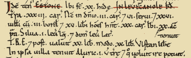
- Hundred: Lewknor
- County: Oxfordshire
- Total Population: 50 Households (very large).
- Total Tax assessed: 20 Geld Units (very large).
- Taxable units: Taxable value 20-Geld Units.
- Value to Lord in 1066 £15 Value to Lord in 1086, £20. Value to Lord c.1070 £15.
- Households: 26-Villagers. 3-Smallholders. 6-Slaves. 15-Free Men.
- Ploughland: 33-Ploughlands (Land for). 3-Lord’s Plough Teams. 30-men’s Plough Teams.

- Other resources: Woodland 10.5 leagues.
- Lords in 1066: Aelfric; Wulfstan.
- Lord in 1086: Baron Miles Crispin.
- Tenant-in-Chief in 1086: Baron Miles Crispin.
Location information
M40 (J6) & Oxford Tube 1-mile
Watlington 4-miles
Haddenham & Thame Parkway 6-miles
(London Marylebone 35-mins)
Henley 15-miles
Oxford 17-miles
Heathrow Airport 31-miles
London 43-miles
Gatwick Airport 67 miles
OS Area Map c.1882

A Single-Line Railway from Princes Risborough to Watlington was Constructed in 1872 & sme Trains ran through to London. It was taken over by the Great Western in 1884. It used to follow the Line of the Upper Icknield Way. It had a Halt at Kingston Blount & a Station at Aston Rowant that achieved Fame in the 1950s by being used in the Films ‘My Brother Jonathan – 1948‘ & ‘The Captive Heart – 1946‘. The Line was closed for Passenger Traffic in June 1957 & was still serving the Cement Works by British Railways.
The Chinnor & Princes Risborough Railway is a preserved Heritage Railway with its Headquarters and only Station at Chinnor. It runs along the foot of the Chilterns Escarpment to Princes Risborough.
Oxon 1897 OS Map XLVII.8 (Aston Rowant Station, Warren Farm, Grove Farm)

Very few people will understand the meaning of the old English word “Flail,” because it is almost 2-Centuries since that old-world Agricultural Implement was in general use. Until Steam was introduced as a Labour-saving Appliance in Agricultural work, Corn was invariably Threshed out of the Ear by Wooden Instruments like that illustrated here, consisting of 2-unequal lengths of rounded Wood of the size of an ordinary Broomstick, connected by Leather Loops. The Farmhands who used this primitive contrivance grasped hold of the Longer Stick & brandishing it about over their heads, brought the Hinged End down repeatedly on the Wheat spread out on the Threshing Floor; thus, with the expenditure of considerable time & muscular strength, separating the Grains from the Ears. As the “Business-end” of the Flail is constructed so as to Swing in every Direction, it is obvious that the Mastery of it was only acquired with practice, & at the cost of sundry Whacks on the Head brought on himself by the clumsy Novice. Indeed, it is an Instrument requiring particular dexterity in manipulation.

Aston Rowant – A Romano Cremation-Burial, apparently of the Late-2ndC, consisting of a narrow-necked, wide-bodied Urn that would hold 2-Quarts found intact & stopped with Lead but Smashed in the vain hope of a Treasure Find but which contained Bone Fragments, a small-footed Beaker & a Samian Patera Stamped SEXTVS.FE – Potters Name (F Oswald, Index of Potters’ Stamps (1931) was Found in 1693 ‘in Kingston-Field – at the bottom of a small Stream called Colebrook, about a Furlong from the Lower Branch of the ‘Ikenild-Street Way‘, thus not far from the Foot of the North Scarp of the Chilterns.

The Aston Rowant Parish has played no prominent part in National Events. It may be significant of Local Feeling that in 1557 Aston Rowant’s Bell-ringers were put in the Stocks by Sir Henry Bedingfield for Ringing to Welcome Princess Elizabeth on her Church Passing Journey from High Wycombe to Rycote. Although Elizabeth was released from the Tower, she was not a Free woman. Her Barge took her from the Tower to Richmond, Escorted by Sir Henry Bedingfield, Constable of the Tower & a Troop of men. After a night at Richmond, Elizabeth & her Guards travelled to Woodstock Palace, in Oxon, stopping at Windsor, West Wycombe & Rycote on the way. On the Journey, Elizabeth was Overwhelmed by the show of Support from the people – she was given gifts of cakes & wafers at High Wycombe, men rang the Church Bells in Aston Rowant & the people of Wheatley, Stanton St John & Islip all turned out to Greet her & show their Support..
In the 17thC both Royalist & Parliamentary Troops probably made Levies on the Inhabitants: a Royalist Troop at Aston was reported to have ‘fetched away a Gentleman’s Coach’ & to have taken Horses from the Country around about. In July 1643 a Great Body of the King’s Horse was Billeted under Aston & Kingston Hills & there was also a Parliamentary Garrison uncomfortably near at Thame.

Dr Robert Plot ‘s Map of Oxfordshire 1676 (showing Chinnor & South Weston Windmills)
Map of Oxfordshire by Phil Overton 1715
It is important to realise that in the 19thC & earlier, Horses were everywhere. On an average Farm the Farmer would have a Horse to Ride round the Farm & possibly to go Hunting. There would be a different Horse to pull the Trap that took the Family to Town or to Church on Sundays. In addition there would be Heavy Horses to Plough & Pull the Farm Carts. Someone would need to look after the Horses. On a large Farm with a well-to-do Farmer every Member of the Family might have their personal Riding Horse (or Pony for the younger children), there would be a number of Working Horses & possibly some Brood Mares with Foals. In such a situation some of the more experienced Agricultural Labourers would be employed as “Horse-Keepers” working Full Time with the Horses.
Aston Rowant lay near on my left, with a Towered Church, a Big House & men upon a Rick, at the edge of the Elms. To cross the Aston Road my way made a slight crook to the left & then skirted the Hay of Aston Rowant Park, with Elms & Sweet Limes amidst the Hay: it was a good grass & clover Track, not deeply rutted. Presently in the mowed & cleared Fields on both sides Cattle were walking out from milking. With another slight Crook to the left the way crossed the High Wycombe, Stokenchurch & Oxford Road, where Yellow-hammers were singing in the Beeches alongside the Telegraph-Posts. My way was now a Hard Road bordered by Beeches & Firs, through which I could see the Tower of Lewknor Church across a Hayfield. A Willow-Wren, with a voice like the sweet voice of someone a 1,000-yrs away, was singing among the tops of the Trees. Below, Briers & Thorns were interwoven & silver-weed grew at the edge of the dust. Some Country people say that silver-weed is good for the feet, a belief which might well have no better foundation than the fact that it grows commonly close to the Road which is cruel to the feet. On the right I passed a little deserted Lodge with pointed windows & doorway gaping blank & on the left a wood of Beech, Elm & Chestnut shadowing a Wall in which there was a door barricaded almost to the Lintel by nettles. This cool Wood was full of the chiding of Blackbirds & 1-Thrush’s singing. Near the end this piece of Road turns decidedly to the left; but over the Wall on the right are some signs of a Track which had not this Southward bend. At the end of the present Road, but a little way to the right along the Road to Wheatfield, which it enters, is Moor Court, a small Old House of Bricks & Tiles, with Wings at each side & a massive Stone Chimney at the Road end; & it has a range of Thatched Farm Buildings & a Line of Lombardy Poplars all enclosed in a Wet Moat.
A little farther up, a Farm Road, which might have continued the Track on the right of the Road just quitted, turns out to the left & with a short break leads to Pyrton, Cuxham & Brightwell Baldwin & so to Wallingford; or from Pyrton the Route might be to Watcombe Manor, Britwell & Ewelme. But the Lower Icknield Way is, to Judge from the Map, supposed to give up its individuality at Moor Court & make straight away through Lewknor & by Sheepcote Lane to join the Upper Road. There seems no good reason why this connection between the 2, if it were such, should have been more than a convenience for a few Travellers, unless we suppose that the very Hilly & Uneven portion of the Upper Road, between the beginning of the separation & Chinnor Hill, so frequently became impassable that it was abandoned for short or long Periods or altogether. But as a Road close to Ewelme was known in the 17thC as the Lower Icknield Way, I was determined to go by Ewelme. From Moor Court I went down to the pretty group of a Smithy, a “Leather Bottle,” & Lewknor’s Towered Church at the Crossing, where I entered the High road, making past Shirburn Castle to Watlington. At Watlington the Road bends sharp to the right, and so comes into Line with the Lower Icknield Way, as it was near Moor Court. Icknield Way by Edward Thomas 1916
Plan of Chalford & Copcourt in the Parish of Aston Rowant Tithes 1840
OS Map of Oxford County Surveyed by a Local man, Richard Davis of Lewknor & Published in 1797. This large Map consists of 16-Sheets at an impressively detailed scale of 1:31,680 or 2-ins to 1-mile. No more than 200-Copies were ever made, evidence being based on all Sets of the Map having Manuscript Serial No.s – this Image is part of No.34. Very few complete Copies survive. In terms of what the Map shows, a clear break has been made from the Christopher Saxton-led Traditional County Map, as here far more detail than previously is featured. Not only are County & Hundred Boundaries, Rivers & Streams, Towns & Villages, Parks & Woodland depicted, but here we have Roads, Tracks, Hedges, indeed every Field can be seen & relief is beautifully represented by the use of hachures. Davis was also Topographer to His Majesty, George III.
The Aston Rowant & Kingston Manors
Aston Rowant Discovery Trail
Public Rights of Way Round Aston Rowant
Within Aston Rowant the Listed Buildings are focused on Church Lane and include the Grade II Church of St Peter & St Paul and Grade II Assets within the Church Grounds, such as the War Memorial & Chest Tombs. The 2-Other Listed Buildings are 20 Church Lane & Aston Cottage.
The Chequers Public House was situated on Church Lane opposite the Church Tower. This Pub was Present by the 1820s & Closed c.1957

Reproduced from VCH Oxfordshire, available online
