
Dorchester Hundred
The Hundred is 1st mentioned in Domesday Book, where most of it forms part of the Bishop of Lincoln’s Fief. Most of the Oxfordshire Estates of the Bishop, which clearly represent the pre-Conquest Endowment of the See of Dorchester, were grouped in the 3-Hundreds of Banbury, Thame, & Dorchester. In Domesday Book the assessment of the Bishop’s Hundreds of Banbury & Thame is given as 100-Hides each; that of Dorchester Hundred is only 95, of which 5 lay outside the Bishop’s Fief. It will, however, be argued that the original assessment of the Hundred was 100-Hides and that by the time of Domesday 5-Hides, which still formed part of the Bishop’s Fief, had been transferred to the neighbouring Hundred of Bullingdon. The arrangement of these Estates in 3-Hundreds is strikingly reminiscent of other Episcopal Triple Hundreds. The most famous is the Bishop of Worcester’s Triple Hundred of Oswaldslow and another is connected with the Bishopric of Sherborne. These groupings seem to have been made in the 10thC, probably in Edgar’s Reign, for the provision of Ships for Naval Defence. Traces of similar groups of 3-Hundreds have been noted in Warwickshire, where they are connected with the provision of Ships, and in Bucks & Cambridgeshire. The origin of Dorchester Hundred as a Grouping of Estates which were probably acquired piecemeal over a long period of time explains its scattered nature. It is impossible to determine the constituent parts of the Hundred in Domesday but there seems to be no reason for assuming that the 11thC Hundred was very different from the Hundred in the 13thC when it comprised the Bishop’s Manor of Dorchester and nearby sub-infeudated parts of the Bishop’s Estate, as well as several detached Estates at South Stoke, South of Wallingford, Fifield in Benson, & Epwell on the County Boundary about 6-Miles west of Banbury.
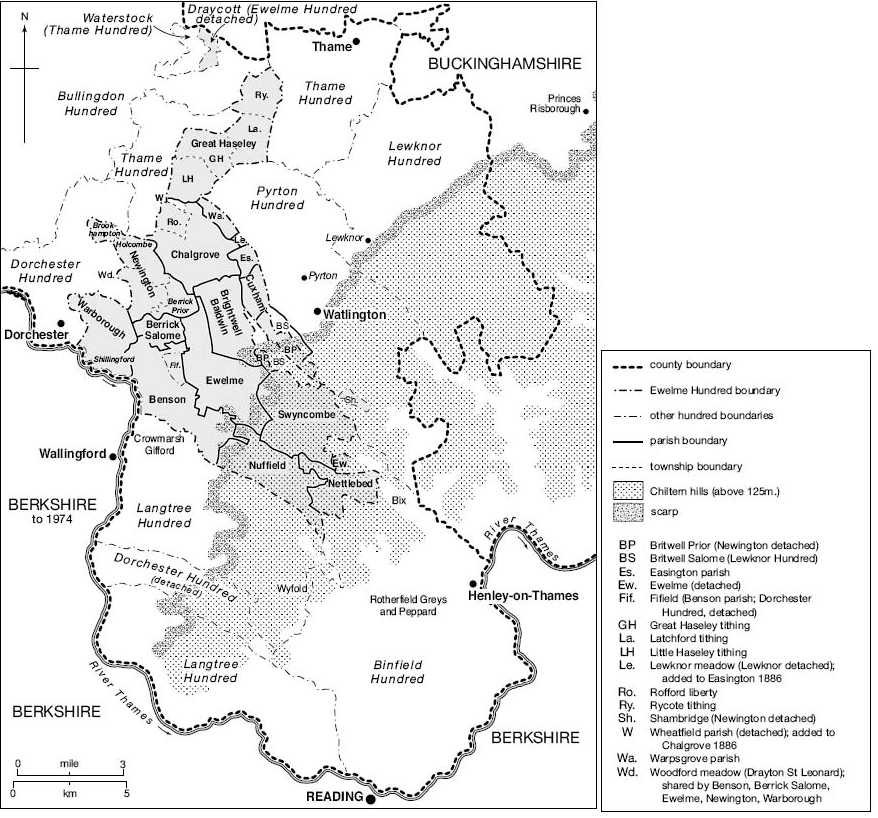
The 1st detailed description of the Hundred was made in 1279. As the beginning of this Survey is mutilated it is not possible to reconstruct the whole Hundred with certainty. As far as can be seen it then comprised the Bishop’s Demesne Manor of Dorchester extending over a wide area, including Overy, Drayton, Burcot, Clifton, Chislehampton, & Stadhampton, and several Fees held of the Bishop, including Nicholas of Burcot’s Fee in Drayton (including Holcombe) & Clifton, William de Baldindon’s 2 Fees in Clifton, Baldon, Burcot, & South Stoke, Philip le Moyne’s Fee in Clifton, Burcot, & South Stoke, a 1/10th-Fee in Burcot held by Geoffrey of Lewknor, and a ½-Fee held by Laurence de Louches in Chislehampton & Little Milton. The detached Estates, also held by the Bishop in Chief, were South Stoke & Woodcote, held by Eynsham Abbey, Fifield in Benson, held by Philip de Hoyville, and a Fee at Epwell held by Robert Danvers. There was also 1 Fee in Chislehampton that belonged to the Hundred but was of the Honour of Dudley and not the Bishops. In the 14thC Subsidy returns the Hundred is taken to include Dorchester, Drayton (St Leonard), Burcot, Clifton, Chislehampton, South Stoke, Woodcote, & Epwell. In 16thC Subsidies, Culham is added to the Hundred. The Hearth Tax Returns of 1665 show that the Hundred remained substantially unchanged, the only alterations being that Exlade, a part of South Stoke, is mentioned separately. By the time of the 19thC Census returns Epwell had been transferred to Banbury Hundred although Fifield (in Benson Parish) remained in Dorchester Hundred until 1881, when it was transferred to Ewelme Hundred.

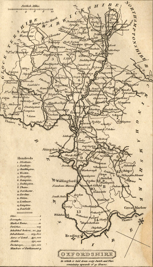
Map of Oxford County
Surveyed by a Local man, Richard Davis of Lewknor & Published in 1797. This large Map consists of 16-Sheets at an impressively detailed Scale of 1:31,680 or 2in to 1-mile. No more than 200 copies were ever made, the evidence is based on all sets of the Map having Manuscript Serial No.s – this Image is part of No.34. Very few complete copies survive. In terms of what the Map shows, a clear break has been made from the Saxton-led traditional County Map, as here far more detail than previously is featured. Not only are County & Hundred Boundaries, Rivers & Streams, Towns & Villages, Parks & Woodland depicted, but here we have Roads, Tracks, Hedges, indeed every Field can be seen, and relief is beautifully represented by the use of hachures. Davis was also Topographer to His Majesty, George III.
Reproduced from VCH Oxfordshire XVIII (2016),
available online at www.british-history.ac.uk/vch/oxon/vol18
