
The Manor of Bensington once belonged to the Royal Duchy of Cornwall: The large & thriving Village of Benson – by far the most Populous Settlement in Ewelme Hundred – lies in the Clay Vale close to the River Thames. Originating as an important Royal Estate-Centre in the mid-to-late Anglo-Saxon Period, in the 18thC it became a Coaching Stop on the London Road, with a relatively Broad range of Trades & a diverse Social Structure. Until the 20thC it nevertheless remained predominantly Agricultural, bordered until 1863 by its large Open Fields & Governed by the usual Rural Institutions of Manor & Parish. Its late-20thC development was influenced by the Establishment of a Wartime Military Airfield RAF Benson which, with RAF Brize Norton, developed into one of Oxfordshire’s 2-Main Military Air Stations. The extended Airfield now occupies much of the former Farmland between Benson & Ewelme. At approaching 3,000-acres the surrounding Ancient Parish was large, encompassing the small outlying Hamlets of Fifield, Preston Crowmarsh, Rokemarsh, and most of Roke. All are included in the following Account.

Parish Boundaries
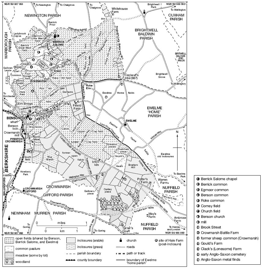
What became Benson Parish emerged gradually during the 10th & 11thCs, as the piecemeal break-up of the Benson Royal Estate (which extended across the Chilterns) created the later pattern of Manors & Parishes. Benson, Ewelme & Berrick Salome formed separate Lordships by 1086, but their earlier Interconnection was reflected in a shared Open-field System which continued until 1863. Consequently their mutual Boundaries were indistinct, definable only by the scattered Open-field Strips belonging to their respective Manors and owing Tithe to their respective Churches. A more clearly defined Boundary along Love & Potters Lanes separated a core area of Ewelme known as the ‘Home Parish’, an arrangement established by the 18thC and possibly from the Middle Ages. In the North, the Hamlet of Roke became divided amongst all 3 Parishes, reflecting Manorial Divisions established by the 13thC, while 3-Cottages in Berrick Salome Village similarly remained part of Benson.
Benson’s Boundaries elsewhere were more clearly defined. On much of the West they followed the 11thC Shire Boundary along the Thames, taking in Islands near Benson Lock, while the North-west Boundary with Warborough (Mapped in 1606) divided Fields & Commons, following in part a straight (and possibly pre-Roman) Lane to Ladybrook Copse. Warborough nevertheless remained closely associated with Benson, containing much of the Manor’s Medieval Demesne. The main Southern Boundary was probably established by 1066 when Crowmarsh Gifford formed a separate Estate, and in part follows indentations suggesting that it cuts through formerly shared Open-Fields. Irregular Boundaries in the South-east brought in Oakley Wood, the Medieval Turner’s Court, and a sliver of Common Pasture at Harcourt or Hartocke Hill, confirmed as belonging to Benson in 1594. Benson also (like most neighbouring Parishes) retained small pieces of detached Meadow in Drayton St Leonard.
An independent Manor at Fifield formed a Detached part of Dorchester Hundred until the 19thC, reflecting its pre-Conquest connection with the Bishop of Lincoln’s Dorchester Estate. By the early 17thC it included a clearly delineated block of old Inclosures totalling 139 a., although as it also contained Open-field Strips its early Boundaries may have been less distinct. For Ecclesiastical & Civil purposes it belonged to Benson Parish throughout, and was counted as part of Ewelme Hundred from c.1882.
Benson’s Boundaries were Rationalised at Inclosure in 1863, creating a Parish of 2,920-acres. Ten scattered Detached areas in the North & North-east (totalling 160-a) reflected earlier complexities. Changes in 1882 reduced the detached areas to 5 (total 154-a), whose removal in 1932 (alongside other alterations) left Benson with 2,748-acres. The projection at Harcourt Hill was transferred to Nuffield at the same time. The changes left Roke still divided between Benson & Berrick Salome, until in 1992 Rokemarsh and the whole of Roke were transferred to Berrick, & Turners Court to Nuffield. Other Rationalisations were made around Oakley wood, Potters Lane, and in the North-West, and in 2011 the Parish covered 2,431 a. (984 ha).
Landscape
Most of the Parish (including Benson itself) occupies open & low-lying Agricultural land on the Thames Floodplain, rising Eastwards, in some places quite steeply, from c.45M by the River to over 100M near Potters Farm, Turners Court & (within the Former shared Fields) North-East of Berrick Salome. The Geology is mostly Gravel rising onto Chalk, while a narrow strip of Riverside Alluvium provided a few small Meadows. North of Roke the Alluvium spreads further, underlying the large former Commons from which Rokemarsh is named. Crowmarsh, by the River Thames, recalls another low-lying Common further South, although there the Settlement itself rests (like Benson) on Riverside Gravel. Until 1863 the rest of the Parish was mostly taken up by the shared Open-fields, with contrasting areas of 17thC Inclosure at Crowmarsh, and of probably Medieval Inclosure interspersed with Woodland on the slightly higher ground in the South-East. Field Names reflected the Terrain and the Soils’ varying quality, with Hill-names predominating North-East of Berrick, Clay-names in the South Close to Ewelme & Moorlands marking a small low-lying Field next to Crowmarsh. Streams are plentiful, that from Ewelme (emptying into the Thames through Benson Village) now partly Culverted, but still Flowing open alongside Brook Street. Others crossed the former Roke Commons, and occasional Riverside Flooding continued in the mid-20thC.
Map of the County of Oxford, from Actual Survey, by Andrew Bryant, in the year 1823. Inscribed by Permission to the Right Honourable the Earl of Macclesfield, Lord Lieutenant, and to the Nobility, Clergy & Gentry of the County. (Click Zoom Button to enlarge)

Communications – Roads: Until 1932 the main Dorchester-Henley Road (Turnpiked in 1736) ran through Benson Village, continuing Eastwards to London & Westwards (via Oxford or Abingdon) to Wales & the Midlands. Roads North-Eastwards Link with neighbouring Villages and the former Market Town of Watlington, while Wallingford, across the River, is accessible via the early-River Crossing at Shillingford & Southwards via the Medieval Bridge from Crowmarsh Gifford. No early River Crossings are known at Benson itself, though by the 1760s a Ferry ran from just South of Preston Crowmarsh Mill, supplemented in the late-19th & early-20thC by others at the Lock & near the Village. The Lock Ferry South of the Lock) continued until the 1960s, to be replaced in the 1980s by a Footbridge across the Weir.
Map of Oxford CountySurveyed by a Local man, Richard Davis of Lewknor and Published in 1797. This large Map consists of 16-Sheets at an impressively detailed Scale of 1:31,680 or 2-ins to 1-mile. No more than 200–Copies were ever made, the evidence is based on all Sets of the Map having Manuscript Serial No.s – this Image is part of No.34. Very few complete Copies survive. In terms of what the Map shows, a clear break has been made from the Christopher Saxton-led Traditional County Map, as here far more detail than previously is featured. Not only are County & Hundred Boundaries, Rivers & Streams, Towns & Villages, Parks & Woodland depicted, but here we have Roads, Tracks, Hedges, indeed every Field can be seen and Relief is beautifully represented by the use of hachures. Davis was also Topographer to His Majesty, George III.
Ordnance Survey Maps 1st Series
Most of the Roads are of Medieval or earlier Origin, but with some changes in their Alignments. The Roman Road from Dorchester to Henley may have run a few 100M North of its Modern & Medieval counterpart, skirting Benson’s Northernmost edge to continue along Love Lane, while the Shillingford Crossing (Established in the Anglo-Saxon Period) was preceded by a Roman Ford a little further West. North of Benson, a partly surviving Track past Hale Farm & Ladybrook Copse may Mark another early-Route connecting with the Roman Road from Dorchester to Fleet Marston (Bucks) & seems to align with the Top of the former Henley-London Road. A Lost Roman Road running down Tidmarsh Lane to Silchester has also been suggested, although the name apparently derives from the Local Tidmarsh Family rather than from Tidmarsh in Berks. Part of the pre-Roman Icknield Way cuts across the Parish’s South-Eastern Edge following the Chiltern Scarp & Rumbold’s Lane (running Southwards along the Brightwell Baldwin Boundary) was a ‘Fielden Way‘ in 887. Most other Major Routes were established by the 17th or 18thCs, while Yeldenbrigge (now Elm Bridge), where the Henley Road crosses the Warborough Boundary Brook, was mentioned in 1301.

Inclosure in 1863 saw suppression of several Field Tracks and re-Routing or Straightening of others, while the Henley Turnpike Road near Potters Farm was diverted c.1827, linking it with a re-Routed Turnpike to Wallingford as part of wider Road improvements. The Route was dis-Turnpiked in 1873. A Benson Bypass running from near Elm Bridge to the Henley-London Road was Opened in 1932 & 10-yrs later (when the London Road was severed by the Airfield) was replaced by a new, more Westerly Road to Crowmarsh Gifford, connecting with the Henley Road along Crowmarsh Hill. A Section Bypassing Crowmarsh Gifford Village was added in the later-20thC, and as part of the A4074 remained the Principal Route towards Henley & Reading in 2015. The truncated old London Road survives as a Minor metalled Road, and the 1932 Bypass as St Helens Avenue.
Tithe Plan of Parish Bensington 1841

Benson’s importance as a Coaching Stop was a direct result of its advantageous position on one of the Routes between Oxford & London. One Route went through High Wycombe and the alternative went through Henley. The Henley to Oxford Road seems to have gained importance in Tudor times. This was partly because it was an alternative Route to London but also because Henley was the Head of Navigation of the Thames for the Large Barges that could not easily Navigate the Shallows, Mill-dams & Flash Locks on the Upper Reaches. Benson was the last Village where Horses could be changed on the Journey from Oxford to London and at that time had Stabling for at least 200-Horses. An Army of Grooms & Ostlers had to prepare the Horses, so that they were ready immediately a Coach arrived in the Village. The Horses could be changed over in a matter of minutes, so that there was a minimum delay for Passengers. The Stroudwater Patent Coach featured an Idle Wheel, so that in the event of an accident causing a Wheel to be Lost, the Idle Wheel could replace it and the Coach could continue its Journey without inconvenience to its Passengers.

Coaching, Carriers & Post
Commercial Coaching between London & Oxford was Established by the 1660s, with Services running via Stokenchurch or Benson. Benson’s leading Inns were being refurbished by c.1700, and by the mid-18thC the Village (Midway between Henley & Oxford) was a Chief Stopping Point for Connections, Refreshments & Changing Horses. Coach-building developed & by the 1790s at least 8-Long-Distance Services passed through twice Daily, together with Mail Coaches & ‘several’ Daily Services from Oxford. Opening of the GWR’s London-Bristol Railway Line in 1839-41 had immediate repercussions, however, leading by 1850 to ‘the entire discontinuance of 30-Coaches that formerly changed Horses there Daily’, and causing Unemployment in the Village. A Benson Carrier died in 1695, and for ‘many years’ until 1775 John Parker of Benson Operated Stage Wagons & Carts from Abingdon to London. London Carrier Services continued intermittently from the 1840s (when Roke had its own Carrier) to 1890s, alongside Services to Oxford, Abingdon & (sometimes) Wallingford & Reading. By the 1920s Carriers ran to Wallingford only. Motorised Bus Services from Oxford & Wallingford were Established by 1920, & by 1939 were extended to Henley & Reading. Even so in 1965 nearly 70% of the Working Population relied on Car Travel. A Post Office was Established by 1809, with Letters delivered in the 1840s through Wallingford. By 1869 it was also a Money-Order & Government Annuity & Insurance Office & a Post Office Savings Bank & by 1876 a Telegraph Office. Sited then near Mill Lane, it moved before 1899 to a Site further along High Street & in 2010 (following a brief Closure) to a Pavilion behind the Village Hall.
River & Railways
During the earlier-Middle-Ages Benson may have benefited from a well-documented River Trade between the Upper Thames & London, its right to Salt Tolls (recorded from the 1260s) perhaps reflecting a pre-Conquest Trade in Salt Shipped downriver from Bampton. From the later Middle-Ages large-scale Cmmercial Navigation this far Upstream largely ceased until the Thames’s re-opening to Oxford from the 1630s; by the 18thC, however, Barges carrying Agricultural & other Goods passed regularly through Benson Lock & a Wharf West of the Church existed by 1717. Even so some London Imports were still Carted Overland from Henley in the 1780s & in the 1750s Benson’s Wharf House was Decayed & the profits minimal. By the 1830s the Wharf dealt predominantly in Coal, and so continued until the mid 1930s, after which it was redeveloped for pleasure Traffic. Benson Lock, associated with the nearby Mill at Preston Crowmarsh, existed presumably from the Middle Ages, and was perhaps the Derelict Weir associated with a Mill c.1375. From the 1580s both Lock & Weir were mentioned frequently, and in 1788 the Flash Lock, with a Winch on the Benson Bank, was replaced by a Gated Pound Lock on the Berkshire side. Even so neglectful Keepers (including Millers) caused occasional delays to Traffic in the 1790s–1850s. The Lock was rebuilt in 1870, when Pleasure Boats were superseding Commercial Vessels, and in 1913 the Keeper’s House was replaced.
Early Railway Links left Benson stranded, and Plans in the 1860s for a GWR Branch to Watlington via Benson were abandoned because of rival Schemes. A Station at Wallingford (c.3 km from Benson) was opened in 1866, however, and another at Watlington (with a line running Eastwards to Princes Risborough) in 1872. In the 1890s an Omnibus ran twice daily to Wallingford from Benson’s Crown Inn, connecting with London Trains, and both Lines still transported Livestock and Agricultural produce in the 1930s, bringing in Coal & Coke, Fertiliser, Cattle Feed & Road Stone. Passenger Services ended in the late 1950s, and the Stations were closed in 1965 & 1961 respectively. Plans c.1898 for a Didcot-Watlington Light Railway across part of the Parish came to nothing.
Benson Population – (Including Fifield, Preston, Crownmarsh, Roke)
In 1086 Benson Manor had 66 Recorded Tenants, although many probably lived outside the later Parish in Warborough, Nuffield, Nettlebed, or Holcombe. Some of the 135 or so Tenants listed in 1279 (excluding Institutions) probably also lived elsewhere, including Nettlebed: certainly not all of the numerous Freeholders were necessarily Resident, although few are expressly known to have held Land in other places. Early 14thC Taxation Lists confirm that Benson was amongst the larger Villages in the Hundred, but not exceptionally so: 24 people paid Tax in 1306 and 26 in 1327, compared with 23 in Warborough, 27 in Ewelme, and as many as 80 in Chalgrove. In 1377, following the Black Death, 206 people aged over 14 paid Poll Tax in Benson & Nettlebed combined, of whom 150 or more were probably from Benson. If so the Village may have had a total population of c.270–325 and c.60–80 houses, although Warborough remained of comparable size, and Chalgrove larger. 16thC Taxation Lists suggest a similar ranking, with 26 Benson Householders paying Tax in 1524 & 8 in 1581, behind Chalgrove in both years.
From the late 16thC Benson’s Population rose in line with National trends, particularly after 1700 as Coaching boosted its Economy. Some 53 Householders paid Hearth Tax in 1662, and 268 ‘Conformists’ (probably Adult Inhabitants) were noted in 1676, making Benson marginally the largest Settlement in the Hundred. That position was Cemented during the 18thC, which saw the Parish’s total Population (most of it in Benson) rise to 811 in 193 houses by 1801, easily outstripping its closest contender Warborough. By 1831 there were 1,266 people and over 220 houses, and though the demise of Coaching & Agricultural depression saw a fall to 965 by 1901 (when 27 Houses were vacant), small-scale growth returned in the earlier 20thC and accelerated from the 1950s, reflecting the RAF presence & Village expansion. By 1931 the Parish Population was 1,264, rising to 2,274 in 1951, and to 4,603 (in 1,315 households) in 1971. Reductions at RAF Benson contributed to slight falls in the 1970s–80s, but population by 2011 totalled 4,754 (1,620 households).
Hamlets
Benson’s Hamlets had much smaller populations. The Largest (Preston Crowmarsh) had 13 recorded Tenants in 1086 and 25 in 1279, but the Black Death left at least 5 Holdings Vacant in the 1350s, and in 1377 only 40 people aged over 14 paid Poll Tax. Seven Householders were Taxed in 1524, and in the 1630s there were at least 9 Houses besides the Manor House. The Estate was later reorganised as 2 Inclosed Farms, though in the 1840s the Hamlet still contained 19 Houses accommodating 93 people. Fifield had up to 19 Tenant Households in 1279, but may have been substantially Depopulated during the later Middle Ages: a Map of 1638 showed only the Manor House, although several other Houses were still counted as part of Fifield in 1662. By 1811 the population comprised only the 16 inhabitants of Fifield Manor.
Tenants at Roke were mentioned frequently from the 13thC, and the total of 6 households taxed in 1662 must represent a substantial under-assessment. By 1841 Roke had 40 Houses and neighbouring Rokemarsh 21, accommodating a combined Population of 270. Over all, some 462 people (37% of the Parish total) then lived in the Hamlets or outlying Farms.

RAF Benson
A Grass Airfield on Farmland between Benson and Ewelme was constructed in 1937/9 as part of the RAF’s pre-War Expansion Programme. Extended hard Runways were constructed in 1942, providing for heavier Aircraft but cutting off the old London Road, which Royal Engineers based at Howbery Park replaced with the current Road to Crowmarsh Gifford. Equipped at 1st with 4-C-Type Hangars and small Domestic & Workshop Blocks.Oxfordshire’s 5th Airfield at Benson started in 1937 and the 1st Units, 2-Light Bomber Squadrons, moved in in April 1939. On 2 September they were off to France with the AASF where in common with other Fairy Battle Squadrons they would suffer appalling Casualties. They were Replaced with more Fairey Battle Squadrons that joined to form No.12 Operational Training Unit, using RAF Mount Farm & Thame (Haddenham Bucks) as relief Landing Grounds. The King’s Flight moved here from Hendon (during 1940/1) but was soon disbanded. The 2nd and arguably most important Phase in Benson’s history began just after Christmas 1940 when Spitfires of No.1 Photographic Reconnaissance Unit moved across from Heston. Benson would now become the focus of PR in the UK covering Europe and Training Crews for Service Overseas. By October 1942 the PRU had become so large that it split into 5 Specialised Operational Squadrons. Throughout the War the PRU and its successors (Flying Spitfires and Mosquitoes) provided crucial strategic information, processed at the Old Mansion in Cottesmore (in Ewelme parish)The main centre for interpretation was Danesfield House, Medmenham (Bucks) and the Benson PR Force was responsible for post-Raid Assessment over German Cities, confirming the success of the Dams Raids, identifying the V-weapons at Peenemunde and preparing for D-Day. Benson’s Spitfires also noted Panzer Divisions around the intended Dropzone at Arnhem, ignored by General Montgomery with tragic consequences. Notable successes included the location of the Bismarck & Tirpitz Battleships, and surveying of D-Day landing sites.

After the War there was some re-shuffling of PR Units which remained here until 1953 when they moved to a new Joint Services Base at Wyton. Much of the work was now damage assessment to British Cities for Reconstruction and for 82 Sqn Survey work in Britain’s Overseas Territories. For a time Post-war Benson housed the PR OTU. Bensons 3rd Phase started with the Basing of the King’s Flight reformed here in 1946 and the Queens Flight remained until 1995, when it was transferred to RAF Northolt. Then a Transport Squadron in 1952. In 1953 the newly expanded Station (with an additional South Runway) assumed a role within Transport Command, ferrying Aircraft across the world. From now until 1992 the Airfield hosted the Tactical Transport Fleet, mainly Argosy then Andover. For 4-yrs it was also home to 3 Fleet Air Arm Reserve Squadrons since their Home Base at Culham could not accommodate Jets then in use. In 1979 the 1st in a Series of Cadet Outfits was based at Benson with a Volunteer Gliding School and in 1992 (on the closure of RAF Abingdon) the Oxford & London University Air Squadrons.

In 1992 60 Sqdn reformed here with the Wessex Helicopter and from that date Benson has been one of the Key Bases for the Joint Helicopter Force. The Wessex was replaced by the Puma & Merlin but in 2014 the decision was taken to concentrate the Merlins within the Royal Navy leaving the Transport Pumas and the Puma – Chinook Training Squadron together with Oxford UAS at this Key Base. It remained a front-line support Helicopter Base within Joint Helicopter Command, accommodating 4 Helicopter Squadrons, several other Units, and some 2,000 Service Personnel & Civil Servants, alongside a similar number of Dependants & Civilian Staff. As the Station’s Role expanded so too did its Facilities, including the development of a large Domestic area (begun by the early 1950s and greatly expanded from the 1970s) East of Green (formerly Clay) Lane near Ewelme, with its own School, Church & Recreational Facilities set within a Fenced Compound. A replica of the Benson Spitfire which photographed the Ruhr Dams after the Raid was placed outside the Station’s Main Gate in 1989.

