

Splendour & Squalor: Shirburn, like other Chiltern Parishes, is Narrow, being only ¾-mile across, and Long, though its 3-miles is nothing compared to the length of some others. It covers 2,421-acres & its Boundaries are probably much the same as they were in Saxon times. Though adjustments may have been made over the Centuries knowledge of the Ancient Boundary was preserved by constant ‘Processioning’. The Custom is referred to in a Dispute which occurred in 1636 between Edmund Symeon of Pyrton & John Chamberlain of Shirburn, apparently over the Customary Right of Parishioners of Shirburn to use a Stile which was actually in Pyrton. A small Stream, flowing Westwards to the Thame, forms the short North-western Boundary & divides the Parish from Stoke Talmage; the County Boundary between Oxon & Bucks Bounds the Parish at the Southern end. The Northern end of Shirburn lies mainly at about 300–ft; it rises gently to 375-ft in the Centre & then steeply to 800–ft on Shirburn Hill, an outlying Ridge of the Chilterns. From here the Land drops away again to 500–ft on the South-Eastern Boundary. This Hill Character of the Southern part of the Parish is reflected in the names of Medieval Fields, such as Wethull, le Knappe, Wouslade (Crooked Valley) & Bradeborweslade (Broadhill Valley).

The Parish is notable for its fine Beech Woods. In the Middle-Ages, it was more thickly Wooded than now, but the Woods were used for Pasturing animals & little care seems to have been taken to preserve the Timber until the 17thC. Shirburn Park, surrounding the Castle, is another outstanding feature of the Landscape & is largely the creation of the 18thC. A Park at Shirburn is 1st mentioned in 1336 when Alice de Lisle received permission to Inclose 100-acres of Wood & 40-acres of Waste to make a Park. Medieval Parks, however, were not Grassland like modern ones & the Land Inclosed is more likely to have been at the Southeastern end of the Parish than around the Castle where the Open-fields lay.
Map of the County of Oxford, from Actual Survey, by Andrew Bryant, in the year 1823. Inscribed by Permission to the Right Honourable the Earl of Macclesfield, Lord Lieutenant & to the Nobility, Clergy & Gentry of the County. (Click Zoom Button to enlarge)
The Road from Watlington to Lewknor, roughly bisecting the Parish & the Road from Swyncombe that joins the Main London Road & crosses the South-Eastern end of the Parish are the only Modern Roads. In early times the Lower & Upper Icknield Ways, crossing the Parish from East to West on either side of the Village, were much used & are considered to be pre-Roman. Many of the early-Furlong names bordering on these Roads contain the element strete. The Upper Icknield Way is now only a Grass Track & the Lower Icknield Way, running from Pyrton to Moor Court in Lewknor, is no longer a through Road though it was still used as one in the 18thC. William Burgess’s Map of 1736 marks a Section of it as ‘Thame Way‘. Knightsbridge Lane, which touched the South-Western end of the Parish, was another Ancient Road, dating from Romano-British times or earlier. It was so named by the Saxons after the Cnihts, young men who were perhaps Settled by the Bridge across the Brook & may have been responsible for its upkeep.

The Landscaping of the Castle Grounds led to alterations in the Roads: a ‘New Way‘, parallel to Knightsbridge Lane and leading by a ‘New Road‘ past the Castle towards the Lewknor-Watlington Road is shown on Maps of c.1718 & of 1780. In 1787 a Section of ‘New Way‘ was Closed after being Viewed by 2-Justices & the Land was appropriated to the use of Lord Macclesfield who gave other Lands for the High Road. The Castle is still perfect & stands in the centre of a Moat, rising straight from the Water. It is reached by 3-Bridges over the Moat, which on the Northside is much broader & is carried 50-yds. further Westward into the Grounds.

The John Buckler drawing of Shirburn Church in 1822 captures the small Medieval & later building before Major 19thC additions & alterations. It also provides a glimpse of neighbouring Shirburn Castle, a Quadrangular Moated Castle dating from the late-14thC which is similar to the better-known Bodiam Castle in Sussex.
The Main Approach, off the Watlington Road 250M South-East of the Castle, runs along the straight Castle Road, flanked by the Walled Gardens to the South & Estate Buildings to the North, arriving at the Gothic Gatehouse (early-19thC), with Studded Double Doors & a Crenellated Parapet, which Stands c.85M South-East of the Castle. The Drive continues North-West through the Stable Yard & beyond, passing the Parish Church to the South. It then curves North through a Belt of Trees, arriving at an open Informal Lawn which Bounds the West Arm of the Moat, at the Centre of which a 2-arched Bridge flanked by Iron Handrails allows Access to the Castle, the 2-Arches being linked by an early-19thC Drawbridge. The West Front overlooks the Park to the West. In the early to mid-18thC Castle Road, then part of the main Village Street, appears to have carried the Principal Approach (Burgess, 1736), when the Road ran South of the Church & Churchyard, turning North & running along the West side of the Churchyard to the Moat & the West Front.

Formerly (later-18th & 19thC Maps) a curving Drive crossed the South Park, entering off the Watlington Road 400M South of the Castle, through an Archway connected to the Gothic, 2-Storey, Stucco South Lodge (early-19thC, possibly John Nash) which stands adjacent to the North, the whole Set within mature Trees. The former Drive curved North across the Park to the West Front of the Castle. Beyond this it continued West through the Pleasure Grounds, crossing the South End of the Lower Duckery & emerging into the Park, curving across to a Belt on the West Boundary. From here it wound through the Trees, terminating at the North End of Pyrton, 800M West of the Castle, at West Lodge (early-19thC, extended late-20thC), a Polygonal, Stucco Building with a Pyramidal Roof, adjacent to Stucco Gate Piers with Iron Gates, attached to a Chalk rubble Wall. Traces of this Drive may still remain. The South Arm was present in the late-18thC (Davis Map 1797), and the West Arm seems to have appeared in the early-19thC (Joshua Bryant, 1823).
OS Map 1919 St Oxon XLVII.10 (Pyrton; Shirburn)
A further Former Lodge, of Brick, probably of 19thC Construction, stands 800M South-west of the Castle, on the South Boundary of the Park, adjacent to Pyrton Lane.
Oxfordshire Map 1881– Adwell, Aston Rowant, Brightwell Baldwin, Brightwell Upperton, Cuxham, Easington, Kingston Blount, Lewknor, Postcombe, Pyrton, Shirburn, South Weston, Watlington, Wheatfield,
The Medieval Village of Shirburn, like other Villages below the Chilterns, was Sited on the Spring Line. It took its name from a Brook, the ‘bright stream‘ (OE scir burna), and its Fields lay on all sides in the part of the Parish known as ‘Below-the-hill‘. Above the Hill lay the Woodland. The Farms & Cottages were clustered around the 2–Manor-Houses & the Church & Lay mostly North of the High Road & not so much South as they do now. The Church, dating perhaps from the late-11thC, is the Oldest Building in the Village. The Castle dates from the 14thC. The Manor-House of West Shirburn, which belonged in the 13thC to Robert de Burghfield is likely to have been on its Site: it is described as lying off the Village Street near ‘Tonus Lane‘. It was certainly not Castellated & the Story that it was visited by Brunetto Latini, the Tutor of Dante, at the end of the Century is a Myth. The Letter in which he describes his Visit has recently been Proved a Forgery. At this Period there was a 2nd Manor-House, that of Henry le Tyeys in East Shirburn. Judging from a valuation of 1307 it was not a large House: it was said to be worth 6s-8d – a little more than some other Houses in the Village, valued at 3s-6d & 4s. These Manor-Houses had probably existed from the time of the Conquest at least & when in the 12thC a Grant was made to Oseney Abbey of 2-parts of the Demesne Tithes of Shirburn, it was stated that they were de utraque curia de Shereburn. It is not improbable that the Lane shown on the Map of 1730, dividing the Castle & the surrounding Houses from Mr Toovey’s House, was the Ancient ‘Tonus Lane‘ & marked the Boundary between what were once 2-Hamlets & that Toovey’s Farmhouse was on the Site of East Shirburn Manor-House.
Shirburn Parish Tithe Map 1843
OS Map 1919 Sth Oxon XLVII.10 (Pyrton; Shirburn)
West Shirburn Manor-House is referred to as late as 1359 in a Lease by Peter de Burghfield, Rector of Burghfield Church in Berks, but after the 2–Manors had been United & Warin de Lisle was Granted Licence to Build a Castle in 1377, it seems that he Built on the Site of this House & that East Shirburn Manor-House, which had belonged to his Ancestors, was allowed to Decay. It was described as ‘Ruinous‘ in 1417.
The Castle was Built mainly of Brick, but the Centre of the West Front was of Dressed Stone & Chalk. There is a record of small repairs being carried out in 1418 & 1419, when Richard Beauchamp, Earl of Warwick, was Lord. The Court Rolls then record a Charge against the Farmer of the Manor, Bartholomew Collingridge, of the Theft of Building material including Freestone, ‘Plankstones‘, & Lead. Collingridge declared he had taken the Lead to put on the Lord’s Tower to make Gutters & do other necessary Repairs & he called John Plomer as his Witness. The Plumber said that he had been ordered to go to Shirburn by Lord Berkeley, then Lord of the Manor & had newly covered the Tower with Lead & made Spouts for the Gutters.
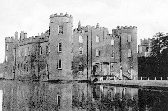
The Castle, as Built in 1377, seems to belong to a recognisable type of Quadrangular Castle, with 4-Corner Towers, that appears in the last-Quarter of the 14thC; it may be compared with Bodiam in Sussex (1385), Castle Bolton, Yorks. (1378), Wressel, Yorks (c.1380), Sheriff Hutton, Yorks (c.1382), and Lumley, Co Durham (c.1392). Shirburn Castle probably consisted of a Quadrangle, enclosed by 4-Ranges of Buildings, with a Round Tower at each Corner & a Gate Tower in the Middle of the West Side. The Living Quarters would have been contained in the 4-Ranges around the Quadrangle; one might expect the Hall to have been on the Eastside, opposite the Gate Tower (as at Bodiam & Lumley). Of the Original Building there survive the Gate Tower, the West Outer Wall, the South Outer Wall (now englobed in later Buildings) & probably the Southwest & Southeast Towers; the other 2-Towers may have been re-Built at the time of the extensive alterations in the 18thC. Originally there were 3-Drawbridges with a Portcullis at the Main Entrance. The wide Moat, – double wide on 1-Side, is of Running Water supplied from Springs on the East side of the Castle & also in the Moat itself. In the 16thC Leland described the Building as a ‘strong Pile or Castlelet‘. Sir Adrian Fortescue was often there after he left Stonor & an Inventory of his Goods at the Castle made in February 1539, a few months before his Execution, throws some light on the internal arrangement of the Rooms at this Period. It mentions the Wardrobe, the Entry, the Great Chamber at the Lower end of the Hall, the Inner Chamber, ‘the Brusshynge Howse‘, the Hall & the Chamber over the Parlour & an Inner Chamber there; there was also a Cellar, Buttery, Chambers each for the Butler, Priest, Horse-keeper, Cook, & Chamberlains, an additional Chamber, a Low Parlour, a Kitchen Larder, Boulting House, Fish-house, Garner, Brew-house, & other Outhouses.
Sir Leonard Chamberlain, another Oxon Commissioner for the Seizure of Church Plate. Sir Leonard owned Shirburn Castle near Watlington, where Sir Adrian Fortescue lived after moving out of Stonor House. He was Henry VIII’s Keeper of Woodstock Park, had served as Official Land Confiscator (Escheator) for Oxon & Berks & was involved in large-scale Trading of Former Monastic Properties

Shirburn Castle, now a Country House. Built 1377, possibly by Henry Yevele (Harvey), for Warin de Lisle: re-Modelled after 1716 for Thomas Parker, Earl of Macclesfield & his son and also in the early-19thC. Brick, partly Rendered: Centre of West Front of Dressed Chalk & Limestone. Roof & Chimney materials not known. Quandrangular Plan with Rounded Corner Towers. Early Perpendicular style, re-modelled in Georgian-style & early-19thC Gothick style. 3-Storeys; symmetrical 7-window Range.
Main West Front: tall Central Gate Tower is flanked by 2, extended in 18thC to 3-Storey Bays: tall Corner Turrets have 2-windows to front. Double-chamfered 4-centred Doorway: Studded Double Doors. Drawbridge leads to 19thC Steps with flanking Cast-iron, Lamps across Moat. Georgian round-headed openings to Sashes & Crenellated Parapet. Other Elevations also re-modelled in early/mid-18thC, including Sashes & Crenellated Parapet. 18thC early-19thC additions and Water Tower of 1870 attached to South Range.
Interior: Hall has early-18thC Staircase with fine carved & turned Balusters. Armoury re-modelled as vaulted Gothick-style Entrance Hall in early-19thC. Re-modelling of c.1830 included Building of Drawing Room & Library to North, Billiard Room converted from old North Library over Hall, Large Bedroom & Dressing Room converted from old Dining Room to East, and Baronial Hall left of Entry. Smoking Room made in North-west Tower in 1873.
Shirburn Castle is the Earliest Brick Building in Oxon: its Plan can be compared with other late-14thC Castles such as Castle Bolton, Yorks, of 1378 & Bodiam, Sussex, of 1385. The Chamberlain Family Held the Castle for Charles I, before surrender to Sir Thomas Fairfax in 1646. Thomas Parker, Earl of Macclesfield & later Lord Chancellor, Bought Shirburn Castle in 1716. The Library which he Founded includes 2–Caxton Editions and the Letters of Isaac Newton amongst its famous collection of Antique Books. The Parkers helped make Shirburn a noted Scientific & Literary Centre in the 18thC: a Pioneering Observatory, since Demolished, was Founded in 1739
Although the position of the Village at the Junction of the Route along the Foot of the Chilterns with the Route which went at right-angles through the centre of Pyrton was Strategically important, Shirburn seems to have played no important part in the Conflicts of the Middle-Ages. The value of its position was no doubt recognised by the Conqueror when he gave the Village to 2 of his most Trusted followers, Robert d’Oilly & Roger d’lvry, but there is no evidence that any Norman Castle was Built there. It has been stated that the Castle was surrendered to the Empress Maud during the struggle against Stephen in the 12thC, but this mistake has arisen from a confusion with Sherborne in Dorset, which was surrendered by William Martel & another mis-statement that the Insurgent Barons met in 1321 under Thomas of Lancaster at Shirburn Castle has arisen from a confusion with Sherburn-in-Elmet (Yorks). The Lords of Shirburn were, however, certainly involved in this 2nd struggle: Lord Tyeys paid for his part in the Revolt against the Despensers on a York Gallows & his brother-in-law, Warin de Lisle, was another Rebel Leader. In the 16th & 17thCs, the ‘Chamberlain’ Ownership of the Castle & Manor made Shirburn a Stronghold 1st of Puritanism, for Sir Leonard was at one time an Ardent Puritan & an active Despoiler of Churches, & then from the time of Mary, of Roman Catholicism. Sir Leonard’s Chamberlain (d.1561) 2nd son George Rebelled against Queen Elizabeth, fled Abroad & married a Dutch Lady. Thus it happened that Shirburn was visited on the occasion of the Funeral of ‘Sir John Chamberlain‘ in 1651 by their Descendant, Dr George Chamberlain, Bishop of Ypres.
During the Civil War, Shirburn was Garrisoned for the King & some of Sir John Chamberlain’s Farm Leases contain the Provision that the Tenant must Fight for the King if called on. In December 1644 Sir Francis Harrington wrote that the Enemy intended Fortifying ‘a Strong Moated House belonging to Mr Chamberlain‘; & that he intended surprising it as it was then only Held by 8-men & 2-pieces of Ordnance: ‘it was 5-miles from Thame & the like from Wallingford, & could‘, he wrote, ‘much straighten the Town, cut off all Provision from Thame – & shut up the Passage to Abingdon‘. Parliamentary Forces were in all the surrounding Villages that year and 120 of their men taken by the Royalists were Imprisoned in Shirburn Castle. In August Sir Thomas Fairfax arranged an Exchange & Major Massie, who was with him at Shirburn, planted 5-Pieces of Battery on the Bowling-green, within a Musket Shot of the Castle & Opened Fire. He was said also to be making preparations to undermine it. In 1646 Parliamentary Troops besieging Oxford again threatened Shirburn & Mrs Chamberlain petitioned Parliament for Terms for the Surrender of the Castle. She claimed that the Garrison had never annoyed the Parliamentary Forces in the past 12-months, but on the Contrary had contributed Provisions to the Troops about Wallingford; that Chamberlain’s Men-at-Arms in the House had prevented it from being an active Garrison which would have much ‘annoyed‘ Henley; that they only stood upon their Guard to Defend themselves from Plunder & never took any Prisoners or raised contributions from the Country. The Parliamentary comment on this was that ‘if true Shirburn had been different to any other part of the Country‘. In June the ‘House‘ was surrendered.
From the end of the 15thC, when ‘Richard Chamberlain‘, his Wife & Chaplain died there, to the Middle of the 17thC the Castle was lived in, at least for a part of the year by the Chamberlains & they Held it for the King during the Civil War. The importance & size of the Building may be judged from the fact that in the 1660’s it was among the 11-Houses in the County for which 30-Hearths or more were returned for the Hearth Tax of 1665. Only the Earl of Lindsey at Rycote, the Earl of Downe at Wroxton, the Earl of Clarendon at Cornbury, Sir Francis Lee at Ditchley, Sir John Lenthall at Burford Priory, & William Knollys of Rotherfield Greys returned more than Shirburn’s 32-Hearths. Cartographer Michael Burghers depicts the Castle on his Map of the County & the Coat of Arms of Lord Abergavenny, then Lord of the Manor, heads the 143-Shields drawn in the Border.

From 1716 until the present day the Parker Family has been Resident at the Castle & by 1900 the Parish was entirely owned by it. Under the 1st 2-Earls of Macclesfield Shirburn became a Centre of Scientific & Literary Renown. Thomas Parker, 1st Earl of Macclesfield & Lord Chancellor, ‘silver tongued‘ Parker, was described by Bishop Warburton as a ‘real Mæcænas‘. He was the Patron of Authors & Founded the Fine Library at the Castle. Both he & his son were Pupils & Friends of William Jones, the Mathematician, who lived at the Castle as one of the Family.

When Thomas Parker, 1st Earl of Macclesfield & soon to become Lord Chancellor, bought the Castle in 1716 he made considerable Alterations both to the Buildings & the Park. A Manuscript Note made by him says that he spent £7,000 on the House. As he bought a Large Library of Books it is likely that he was responsible for the 2-Famous Library-Rooms & the Main 18thC Alterations. These included the rebuilding of the South & East Ranges, the construction of the Fine Staircase in the Northeast Corner & the remodelling of the North & West Ranges. The present South Range may represent the Medieval South Range, with new windows inserted & with another Range of Rooms added to the South, outside the original Outer Wall. The West Range, containing the Gate Tower & the old Kitchen, was left comparatively unaltered, except for new windows and the addition of a 3rd-Storey, thus raising this Range to the height of the others & dwarfing the Gate Tower. The North Range, when Brewer described it in 1819, contained the ‘Capacious’ North Library over the Armoury & also on the Ground Floor were Marble Baths, both Warm & Cold, ‘a luxury that too tardily creeps on the Notice of this Country‘. The Armoury was the present Entrance Hall which had probably been comparatively recently remodelled in the ‘Gothic‘ taste & was shortly to be Illustrated in Skelton’s Antiquities of Oxfordshire.

The 2nd Earl, Member for Wallingford 1722–27 & President of the Royal Society in 1752, took a keen interest in Astronomy and spent much time at Shirburn Studying under Jones. With the Aid of James Bradley he Built in 1739 an Astronomical Observatory, where he Trained 2-Assistants, Thomas Phelps, the real Discoverer of the Great Comet of 1743, & John Bartlett. One was originally a Stable Boy at Shirburn, the other a Shepherd of Stoke Talmage. Together with the 2nd Earl they made many Observations. The Earl, besides being responsible for introducing the new style Calendar, built a Large Chemical Laboratory, added greatly to the Library & Patronised the Arts, His eldest son, Lord Parker, contested Oxfordshire in the New Interest in the Great Election of 1754, an Election which was notorious for the vast sums spent by both sides. Lord Macclesfield gave a Feast to 300-Freeholders of Watlington in 1752, Establishing himself as the ‘darling of all this part of Oxon‘ & another in 1753. Oxford Dons dubbed Lord Parker ‘goody Bribery of Shirburn‘ & another of the cries of the Opposition’s Supporters was ‘give us back our 11-days‘. Four out of Shirburn’s 6-Freeholders Voted for Parker & Turner: these included 2–Tooveys – Richard of Watlington & Samuel of Shirburn.

The changes made during the 18th & 19thCs in the surrounding Grounds were equally spectacular. A Map of about 1718 shows the Castle & Moat with a Bowling-green & Garden on the South-west side covering 5-acres. The Church & Home Farm also Lay to the South-west & to the North was the Kitchen Garden. The Great & Little Closes, Forty Acres, & Mill Furlong, lying North & South of the Castle were at this date Arable Closes. William Burgess’s Map of 1736 presents quite a different Picture. The 1st Earl made many exchanges of Land, mainly with the Tooveys, so as to be able to enlarge his Pleasure Grounds & divert the old Public Road. In 1720 he made the large Ornamental Water, called Upper Duckery & by 1722 Homefield (30-a) & Mill Furlong (50-a) had been laid down to Grass & Avenues of Dutch Elms planted in Mill Furlong – alas no more. The Nursery was planted a few years later, the Long Pond was made out of the one-time Millpond: this marshy Ground was Purchased from Mr Samuel Toovey on condition that the new ‘Pond‘ should not injure in any way Toovey’s Property. The Map of 1736 shows a Formal Garden to the North of the Castle & on the East a Path running from the Castle to a Circular Lake & Temple. Two Designs for a Garden Temple bearing the Macclesfield Arms are in the Avery Library of Columbia University, USA. They are attributed to the Architect, John Sanderson (d. c.1783?). The existing Circular Temple appears, however, to have been designed by Westby Gill of the Office of Works, for ‘Mr Gill‘ is referred to as the Architect in Letters from the London Mason, Andrews Jelfe, relating to the supply of Portland Stone for its Construction in 1741.
In 1739 the Astronomer 2nd Earl, George Parker with the help of James Bradley Built the Observatory; 20-yrs later the 1st part of the Walled Garden was made, the Home Farm was moved & in 1770 the Churchyard was transferred from the Northside of the Church to the Southside.

The Observatory
Thomas Phelps, “who from being a Stable-boy in the year 1718, to the then Lord Chief Justice Parker, afterwards Earl of Macclesfield, rose by his merit to the upper Employments in that Family & at last, for his uncommon Genius, was promoted to be Observer, in their Observatory“. John Bartlett was “originally a Shepherd, in which Station he by Books & Observation acquired such knowledge in Computation & of the Heavenly bodies, as induced the late George, Earl of Macclesfield, to appoint him Assistant Observer in his Observatory“. Phelps & the younger Bartlett are shown in the Observatory’s Transit Room, with Phelps at the Eye-piece of the 5ft Transit Telescope, made by Jonathan Sisson. His Transit Telescope used a hollow-cone Design for its Axis, a Design adopted by later Instrument Makers such as Jesse Ramsden. This Instrument is fixed to supporting Pillars & aligned to the Meridian in order to ensure the Accuracy of repeated positional Measurements of the Heavenly Bodies. Behind Bartlett is an Astronomical Regulator, an accurate Observatory Clock, by George Graham. To the left is an Equatorially-mounted Telescope, probably by John Dollond. These were tip-top London Instrument Makers. Macclesfield spared no expense to create an Observatory that, with a salaried Observer & Assistant, rivalled or, indeed, trumped the Establishment at the Royal Observatory in Greenwich.
Macclesfield was a remarkable Individual. He was Instructed in Mathematics by Abraham De Moivre & William Jones & the Sciences became his Passion. Under Jones’s influence, he formed an exceptionally Important collection of 17thC Mathematical Manuscripts & Books. He Erected his Observatory with the assistance of James Bradley, then Savilian Professor of Astronomy at Oxford & later Astronomer Royal. He also Built a Chemical Laboratory, in which his Observer, Thomas Phelps also assisted. Macclesfield was, as well as being an MP, President of the Royal Society for 12-yrs, from 1752 until his death. From both positions, he was a Principal Proponent of the Adoption of the Gregorian Calendar.
His son, Thomas Parker, 3rd Earl of Macclesfield, was also elected FRS & evidently kept the Observatory going, under Phelps & Bartlett, joined in about 1776 by someone called Redding. Regular Observations seem to have ceased in the 1790s. This Engraving is a remarkable celebration of 2-relatively unknown Individuals who, otherwise, survive only in the Manuscript Observations. It is relatively rare, before the advent of Photography, that we see images of people engaged in the activity of Astronomical Observation. It is also rare to see the Assistants, rather than the Owner of such Fine Instruments. The Engraving is, of course, also a celebration of those Instruments, which were still impressive in the 1770s. In addition to the Telescopes & Clock, core Tools of the well-equipped working Observatory is a Celestial Globe. This plays an iconographic rather than a practical function & is unlikely to have been placed in the Observatory itself.
Thomas Phelps (1694-1776) was an English Astronomer. Born in Chalgrove, Oxon, he began his career as a Stableman in the Service of Lord-Chancellor Thomas Parker. In 1742 he was allowed access to the Observatory of George Parker, 2nd Earl of Macclesfield. It was here that Phelps became the 1st in England to detect the Great Comet of 1743. His Observations of the Comet on 23rd December, were Published Anonymously in ‘Philosophical Transactions‘.
Map of Oxford County 1797: Surveyed by a Local man, Richard Davis of Lewknor and Published in 1797. This Large Map consists of 16-sheets at an impressively detailed Scale of 1:31,680 or 2-ins to 1-mile. No more than 200-Copies were ever made, evidence being based on all Sets of the Map having Manuscript Serial No.s – this Image is Part of No.34. Very few complete Copies survive. In terms of what the Map shows, a clear break has been made from the Christopher Saxton-led Traditional County Map, as here far more detail than previously is featured. Not only are County & Hundred Boundaries, Rivers & Streams, Towns & Villages, Parks & Woodland depicted, but here we have Roads, Tracks, Hedges, indeed every Field can be seen, and relief is beautifully represented by the use of Hachures. Davis was also Topographer to His Majesty, George III.
In 1790 Davis advertised his intention to Publish in 1792 a Survey of Oxfordshire on a Scale of 1-inches to 1-mile, this scale being specifically chosen to complement the 18-sheet Map of Berkshire by John Rocque who had held the post of Topographer to His Majesty, a Post to which Davis himself was appointed in 1786. Subscriptions came slowly, however & it was not until 1797 that the Oxfordshire Survey was finally Published on 16-Sheets at £3-10s-6d including full Wash Colour and a Key Map. All Subscribers’ Copies were numbered on the Title Sheet & individually signed by Davis himself; the highest recorded Serial No. of 159 suggesting a Total Printing of fewer than 200-Copies. Of particular interest is the Plan of the University & City of Oxford, similar in scale & Ichnographical detail to the Plan of the City by Isaac Taylor in 1751 but with some updating, notably the intersection of the Oxford Canal, which Opened in 1790. The Cartographical Detail is immense, well worthy of an Estate Surveyor of Davis’s reputation & takes full advantage of the larger Scale. In the Villages & Rural Areas almost every House & Farm is shown with its Land & even in the Towns, there is a great effort made to make them Ichnographically correct. The Road system is extensive; from Major Roads with their distances from Oxford & London & between the Major Towns, down to Minor Roads & Bridle Paths. Further detail includes Hills & Woods, Heaths, Parks & Commons, Mills, Churches & Farms, whilst Gentlemen’s Seats & Large Houses are shown in profusion.
Between 1780 & 1807 further improvements were made. Davis’s Map of 1790 shows the Dutch Elm Walk, the Terrace Walk, & the Clare Walk to the North & North-West of the Castle; there was a new Flower Garden & Lower Duckery had been made. From a Map of 1807 a New Orchard laid out to the North of the Castle can be seen; the Gardens to the South-west have been enlarged & now include a Melon Ground, and the Ponds to the West of the Castle have also been Enlarged. In these improvements, a Mr Ryston was the Earl’s Adviser. By 1819 the Park was said to cover roughly 60-acres: it was not admired by Brewer in his Guide who considered it ‘too flat to afford much interest‘. Lord Torrington, writing earlier, in 1785, was even more critical of the Park & also of the House. He found the Castle ‘melancholy & tasteless‘ in appearance & the place ‘very ugly‘ & ‘in a very ugly Country‘. But he was not in a position to give an unprejudiced view, for he had twice been refused Admission, the 2nd time after a ‘tedious sultry ride of 16-miles‘. Another contemporary view was that it was ‘sublime’ & left an ‘irresistible impression on the Soul of Taste & Sentiment‘. A Conservatory of Freestone & Cast Iron & a Pavilion for Flowers were Constructed early in the 19thC, perhaps in anticipation of the Royal Visit in 1808 of Queen Charlotte & Princesses. The fine Wall separating the Park from the Lewknor Road is mainly built of Chalk & Brick & is largely late-18thC or early-19thC Work.
The enlargement of the Park & the Inclosure of the Open-fields in 1806 led to great changes in the Village. All the Farmhouses below the Hill once lay in the Village & were mostly West of the Lewknor Road & to the East of the Castle. In the mid-17thC, there had been 11-Farmhouses rated for the Hearth Tax, of which 4 had 3 or 4-Hearths. How many Cottages there were is uncertain, but Rentals show that there must have been many Families which escaped Taxation. Village Society had its clear distinctions of Rank: in 1622, for example, Elizabeth Adeane left 12d to every Cottager of the Town & in 1642 Richard Adeane left 12d each to the 4-Poor of Shirburn. The Estate Maps of 1736 & 1780 show the Farms & Cottages mainly around the Church & Castle to the West of the Lewknor Road. The Pound was opposite Scole’s Farm, which lay on the Corner of the Lane leading to the Church; the Village Cross was where the Lane joined the Lewknor Road. Several of the Large Farmhouses like Scoles’s, Butt’s, & Reading’s had Large Orchards. After Inclosure the Roads were Fenced in & the Cross was removed. New Farmhouses were Built: the Map of 1807 shows Stone Hill Farm (later Model Farm) & Shirburn Farm to the North-west & North-east of the Village & Knightsbridge Farm in the Open-fields to the South-west.
Judging from Brewer’s Strictures the Cottagers were neglected. He noted that there were ‘many huts of the most wretched description which act as offensive foils to the massive splendour of the neighbouring Castle‘. The 6-Derelict Cottages then standing empty on the Lewknor Road were probably characteristic of the 18thC Village: they were Timber-framed & have partly Brick & partly Lath-&-plaster Filling. The Roofs are Thatched. Cottages & Houses were restored or newly Built in the course of the late-18th & 19thCs. There is a Row of 14 pleasing Cottages in Blenheim Road, a Lane branching off the Lewknor Road. They were designed as a Row & are mostly of 2-Storeys, but 4 have Dormer windows; the material used is Chalk with Brick for decoration & for the Chimney-Stacks. Two of the present-day Cottages were once a Bakery, but one was recently used as a Village Shop. A Group of Houses facing towards the Lewknor Road & inside the Entrance to the Castle Stables are also Built of Chalk & Brick & appear to Date from the late-18th or early-19thC. In the mid-19thC, a School was built. There has been no expansion in the 20thC: in 1960 there were reckoned to be 56-Houses in the whole Parish compared with 62 in 1811.

The only Houses of interest besides the Castle are the Castellated Lodge on the Lewknor Road, possibly Built before 1805 by John Nash, who is known to have designed a Cottage for the Earl of Macclesfield; the early-19thC West Lodge, which actually lies just in Pyrton; & Shirburn Lodge, an 18thC Building, magnificently situated on the top of the Chilterns & overlooking the Oxon Plain through a glade cut in the Woods. This last House was originally Built by Joseph Collett of Hertford Castle, who bought some of Shirburn’s Woodland in 1722 but was much Altered after 1775 when the Earl of Macclesfield bought it back & it was used as a Dower House. It is constructed of Flint with Toothed Brick Quoins & window surrounds. The West Front has 3 2-light Dormer Windows & 5-Bays, the Centre Bay projecting slightly. The Central door, with Arched Fanlight over it in an Arched opening with Stone Key-block, dates from the 19thC when a Wing was also added.
Shirburn Lodge c.1730, for Joseph Collett; enlarged c.1830. Knapped Flint Rubble, Brick Quoins & Dressings. Welsh Slate Roof; Brick Stacks. Double-depth Plan. Early Georgian style. 2-Storeys & Attic; symmetrical 5-window Range with central 2-Storey Porch. Keyed round-arched Doorway to 2-panelled double-leaf Door with decorative Fanlight: 6-panelled inner Door. Gauged Brick flat arches over 6-pane Sashes with thick glazing bars. Moulded String Course; gauged Brick moulded Cornice beneath Parapet. Hipped Roof with 3-Dormers; symmetrical end Stacks. Similar Rear Elevation has similar Sashes with surrounds & Flat Hood over Central Doorway. Extension to Right c.1830, of Flemish Bond Brick with 5-window Front Range of similar Arches over Sashes flanking Central Canted Bay & 1st-Floor Sashes: Stone moulded Cornice.
Interior: panelled Open Hall to Right has 2-Bay Doric Screen & Open-well Staircase with turned Balusters, & Urn Finials to Newel Posts. Panelled Ground & 1st-Floor Rooms with Fireplaces. Early-18thC Fireplace in Ground-Floor rear left Room: early-18thC Fireplaces & panelled Dados in rear left and rear 1st-Floor Rooms. Bolection-moulded Panelling in tall early-19thC Room to right. The House was bought by Lord Macclesfield who used it as a Dower House c.1775.
Stables & Coach House, now House. Early-18thC. Knapped Flint coursed rubble with Brick Quoins & Dressings; Hipped 20thC Tile Roof; Brick end Stacks. Double-depth Plan. 2-Storeys; 4-window Range. Segmental Brick arches over 8-panelled Door to left. 20thC Door to right & tall blocked Doorways. Flat Brick Arches & Timber Lintels over blocked 1st-Floor windows. Coach-house Doors in the left Sidewall. Brick Rear Range with half-Hipped Old Tile Roof, and large Interior Fireplace.
In 1830 a fairly extensive Modernisation was undertaken – a Drawing-room & Library over it were added on the Northside; the old North Library over the Hall was converted into a Billiard Room; the former Drawing-room which had been over the Dining-room on the East side was converted into a larger Bedroom & a Dressing-room; & the Baths on the Ground Floor on the Northside were removed. In 1870 the Red-Brick Water Tower adjoining the Laundry was Built & in 1873 the Warder’s Room in the North-West Tower & the low Entresol (Mezzanine) above it were thrown into one to make a Smoking-room.
As 3rd Earl of Macclesfield, Thomas Parker made further additions to the Library & by the time of his death in 1795 the 6-Collections for which the Library is Famous had been brought together, and 12,700 or so Printed Books & 260-Manuscripts had been Assembled. The additions since his time have been negligible. It consisted of:
(1) the Valuable Collections of Scientific Works & Letters collected by William Jones and Bequeathed to the 2nd Earl;
(2) about 450-Bibles;
(3) the Welsh Collection of the Welsh Antiquary, the Rev Moses Williams, which was left to William Jones;
(4) a Large Collection of Books on Linguistics;
(5) 2 Important Collections Bequeathed to the 3rd Earl. The 1st of the last 2-Collections came from the Master of the Rolls in 1754, the 2nd consisting of Military Works came from the Hon George Lane Parker, the Earl’s brother.
The Library contains many 1st Editions of early-English Books, including 2-Caxtons, and among its most valuable Manuscript Possessions is the unique Liber de Hida & many Letters of Sir Isaac Newton.
Amongst the Portraits at Shirburn Commissioned by the 1st 3-Earls are one of Thomas, the 1st Earl by Kneller; George, the 2nd Earl by Hogarth and of his 1st wife by Kneller; of William Jones by Hogarth; and of Thomas the 3rd Earl and his wife by Ramsay. This Tradition of Patronage of Leading Artists was followed by George, the 4th Earl, who Commissioned Ramsay to paint his wife Mary Frances.

“The excitement of the Macclesfield Library lies not only in the splendour of its Holdings but also that it has never been accessible or much known about.” The fabulousness & stratospheric importance of the Shirburn Library, ‘an Intellectual Time-capsule’ – The Dispersal at Auction of the renowned Scientific Library of the Earls of Macclesfield from Shirburn Castle has been held at Sotheby’s, London, in the Period March 2004 to November 2005 in 6-Sales following upon the Sale to the Cambridge University Library of the Macclesfield Scientific Papers. This Paper by Sotheby’s expert Paul Quarrie who Catalogued the Sales, discusses aspects of the History of the Library, its Genesis & Composition, the Personal History of those who created it, & certain individual Volumes. There have been 12-Sales yielding in excess of £22M & peaking in the £1.6M paid for a “stunning” 14thC Illustrated Book christened the Macclesfield Psalter. Separately, a Cache of Isaac Newton’s Papers have been Sold to Cambridge University for £6.37M & only last December a barely-known Stubbs Masterpiece netted the another £9M

Lord Parker Hunted the Countryside for 2-yrs until 1847, when he gave it up & Mr John Shaw Phillips succeeded him. His Lordship, however, now Earl of Macclesfield, after some years resumed Office, becoming Joint-Master with Col John William Fane, of Wormsley, in 1857 & the Joint Mastership continued for 3-Seasons. The Earl bought the Pack Outright & his memorable Period of Mastership extended until 1884. The long Reign of the Earl of Macclesfield may well be called the ‘Palmy Days’ of the South Oxfordshire Hunt, for his Lordship was not only a particularly fine Judge of a Hound, but possessed a thorough knowledge of the Huntsman’s Art, while his personality & charm of manner ensured him such measure of Popularity as falls to the Lot of few. Until quite the latter end of his Mastership Lord Macclesfield rode straight to his Hounds whether in the Woodlands, Vale or on the Hills – indeed his method of Riding through the Beech-woods in the Latter District, with the Reins hanging loose on his Horse’s Neck, could only be copied by a man of indomitable nerve. The Kennels in Lord Macclesfield’s time were situated at Shirburn Castle, his Seat beneath the Chilterns & they were consequently a long way from some of the Friday Fixtures; in 1884 new Kennels were built at Stadhampton Green & the Pack has been quartered there ever since. In addition to bringing the South Oxfordshire Pack to a high pitch of excellence, Lord Macclesfield Planted several Coverts, notably Cornwell Gorse, more familiarly known as The Gorse. This Covert was one of the best in the Country, situated as it is in a Sea of Grass; & though at the present time the Gorse itself has vanished, strong growth of Blackthorn has replaced it & it is seldom that this Covert is drawn Blank. In the Earl’s time also a Covert was Planted by subscription at Kimble Wick on the extreme East of the South Oxfordshire Country. This, however, was subsequently claimed by the Old Berkeley (West) on the Ground that it had been Planted on the wrong side of the Boundary; the Case was referred to the Masters of Foxhounds Association & was a subject of much discussion at Boodle’s Club (50-Pall Mall), until the Verdict was given in favour of the Old Berkeley. That Hunt at the present time looks upon Kimble Wick as quite their best Covert, standing as it does in the Aylesbury Vale & the Country around it forming a pleasant contrast to the Flinty Hills & Beech-woods which form the greater part of their Country. Lord Macclesfield had at one time an excellent Staff in W Grant & Harry Molyneux; Harry left to become 1st Whipper-in to Mr Garth & after spending a long time with that Pack was appointed Huntsman to the Burstow (Surr). Two quicker Hunt-servants than these 2 would be hard to find & during their Service with the South Oxfordshire Sport was 1st-Rate. Lord Macclesfield:-
Went on to Turner’s Wood from which a Fox broke immediately, ran quick across into Boarstall Wood, but he only just went inside the Lower Wood Hedge & away from the Middle Ride. We then went at a Capital pace by the Decoy over Muswell Hill & the Earths down the Hill leaving Rush-Beds on the right, crossing the Bicester Road, the River Ray & Marsh Gibbon Field to within a 100-yards of Marsh Village. Here our Fox changed his Point, turned short to the left running very short and Pointing for Gravenhill Wood but after re-crossing the Bicester Road & skirting Blackthorn Village we got on bad terms with him & only by the help of Holloas marked him into Ambrosden; here he jumped up in the Ruins & dodged about the Village for some time but was Lost after all.

In 1837 Mr Morland lent 10-Couple of Hounds to Major Fane of Wormsley, who then resided at Shirburn Lodge & had his Kennels at the Foot of Pyrton Hill; with these Hounds, he Hunted what is now known as the South Oxfordshire Hill Country. In 1841 Mr Morland gave permission to Mr John Shaw Phillips to draw some of his Oxfordshire Coverts, & lent Elsfield & Woodeaton Coverts to the Bicester; it would seem, however, that Mr Phillips had the right to draw the Elsfield Coverts prior to this date, for the New Sporting Magazine of April 1835, contains an account of a good Sporting Run from Stow Wood. On that occasion, Hounds found a Leash of Foxes in one of the Elsfield Woods.
New Sporting Magazine 1831 Vol-1
New Sporting Magazine 1834 Vol-7
New Sporting Magazine 1835 Vol-8
New Sporting Magazine 1837 Vol-12
Shirburn: Baptisms 1587 to 1980, Marriages 1590 to 1980, Burials 1598 to 1975
Reproduced from VCH Oxfordshire available at British History Online
