1stC Anglo Saxon: Bleddanhlaewe

The earliest Documentary reference to Bledlow occurs in the Will of the Lady Ælfgifu, Widow of Edwig, King of the West Saxons. The Will is undated but was apparently made after her husband’s death, between 967 and the death of her brother-in-law, King Edgar, in 975. It contains the following clause: “First, she Grants to the Old Minster where she intends her body to be buried, the Estate at Risborough (Hrisanbeorgan) just as it stands, except that, with your consent [the King’s] she wishes that at each Village every penally enslaved man who was subject to her shall be freed; and [she Grants] 200 Mancuses of Gold to that Minster and her Shrine with her Relics. And she Grants to the New Minster the Estate at Bledlow (Bleddanhlaewe) and a 100 Mancuses of Gold.” We do not know the extent of the Lady Ælfgifu’s estates in Bledlow, but these must have been of some value. Doubtless, the Rents & Dues would be collected by an Official on behalf of the New Minster. – (Mancus – Gold Coin)
The 1st mention of Bledlow in post-Conquest Records is in Domesday Book, where the following entry occurs:
“The Land of the Count of Mortain in Riseberg Hundret. The Count himself holds Bledelai. It is assessed at 30-Hides. There is Land for 18-Ploughs. In the Demesne are 16-Hides, and on it are 4-Ploughs & 32-Villeins with 3-Bordars have 14-Ploughs. There are 8-Serfs & 1-Mill yielding 24-Loads of Malt, Woodland [to feed] 1000-Swine & producing in Rents a sufficient supply of Shares for the Ploughs. Meadow is there [sufficient] for 18-Plough [Teams]. In all it is worth £22; when received £12; TRE [in the time of the Confessor] £20. This Manor Edmer Atule a Thegn of King Edward, held & could sell.
Paper Mill – Also known as Bledlow Lower Mill or Lower Saunderton Mill, this Mill lies on the Cuttle Brook Stream. A large Building constructed of Red Brick, with areas painted Cream, at the time of Stanley Freese’s visit in about 1930 the Exterior had become disfigured by the attachment of tarred Galvanised Ironwork. It was still in working order. In its life, the Mill has been used both for grinding Corn & Paper Making. This Mill had an Overshot Waterwheel.

At the time of the Domesday Survey there was one Mill in the Parish, which yearly yielded to the Lord of the Manor 24-Loads of Malt. It was presumably the same Mill that Hugh de Gurnay excepted from the Grant of the Manor to the Abbey of Bec & which at that date, 1198, was held by Simon Hochede. In 1240/41 Alice, Widow of Simon, sued William Neirnuit for the 3rd part of certain Tenements, a Mill with its Appurtenances being specified. A 2nd Simon, the Heir, was in Wardship & Juliana de Gurnay, also a Minor, was the Overlord of the Tenements in question. Some years later Nicholas Hochedee appears in a Suit as to Land in Bledlow, but the Mill is not mentioned; in 1304, at the death of Hugh Bardolf, the Rent of a Watermill was Held by Christiana, daughter of Reginald de Hampden.
In the 13thC the Abbot of Bec claimed to hold View of Frankpledge, Gallows, Waifs & other Regalia in the Manor of Bledlow, basing his Right on the Grant of Hugh de Gurnay, his Feoffor & its Confirmation by Henry II.
OS Map 1881 – Bledlow, Wainhill, Horsenden, Pitch Green, Culverton
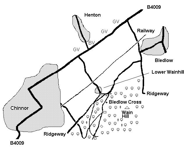
The Higher Slopes of the Hills are in parts well Wooded & in one of the open spaces, on the North slope of Wain Hill, is the Bledlow Cross, cut in the Turf, & visible for miles as a Landmark. This is a small simple Cross 71-ft x 69-ft that seems to have grown considerably it was only 30-ft ‘square’ in 1827. It probably cut in the late-1700’s although the 1st irrefutable reference being from 1827 (the Cross was in disrepair at that time) although a reference to a Henry Atte Crouche (Cross) of Bledelaw (Bledlow) in 1350 is plausible. Realistically it is rather to vague to give much weight to & authoritative 1700s Texts give no mention of it. The Origins are also unclear with the conversion from an existing Symbol being one of the most likely theories. Its proximity to the Icknield Way and that of the Whiteleaf Cross & Watlington White Obelisk, surely can be no accident. It has been suggested that they might be Way Markers for Drovers or Travellers. A combination of both of these theories suggests that the Figures were cut or altered by Local Monks. Another theory suggests a Memorial for a Victory by King Alfred.


Just South of Henton on the Upper Icknield Way and the Cuttle Brook was the Ancient Hamlet of Wainhill, commonly spelt in early documents and still pronounced Wynnal, and once called Hempton Wainhill. It had a Mill in the Middle Ages and seems to have had an uninterrupted existence, though it has diminished in size. Its Public House, the ‘Leather Bottle‘, was closed about 1910. This Pub was Present by 1811 but was Closed in 1911 when the Owning Brewery (Wheeler’s Wycombe Breweries) Voluntarily surrendered the Licence. In the early part of the 20thC, there was a strong Temperance Movement in England. The view that arose from this Movement was that there were too many Public Houses compared with the needs of the Public. Under the Terms of the 1910 Licensing Act. Brewers would Pay a Levy, the Licensing Magistrates would select Pubs that they considered Redundant, not renew the Licence & then pay Compensation back to both the Brewer & their Tenant. Wheeler’s may have still Owned the Property & the Tenant may have Rented it until 1925, however, it could not be Licensed again after 1911. It is still in Residential use. The extant Building is still called The Leather Bottle.
The Ordnance Survey Map of 1919 marks a Lower Wainhill on the Site of Wynnal Closes, a little to the North & it may be that there was once a 2nd small Settlement here. There is now only one House surviving.
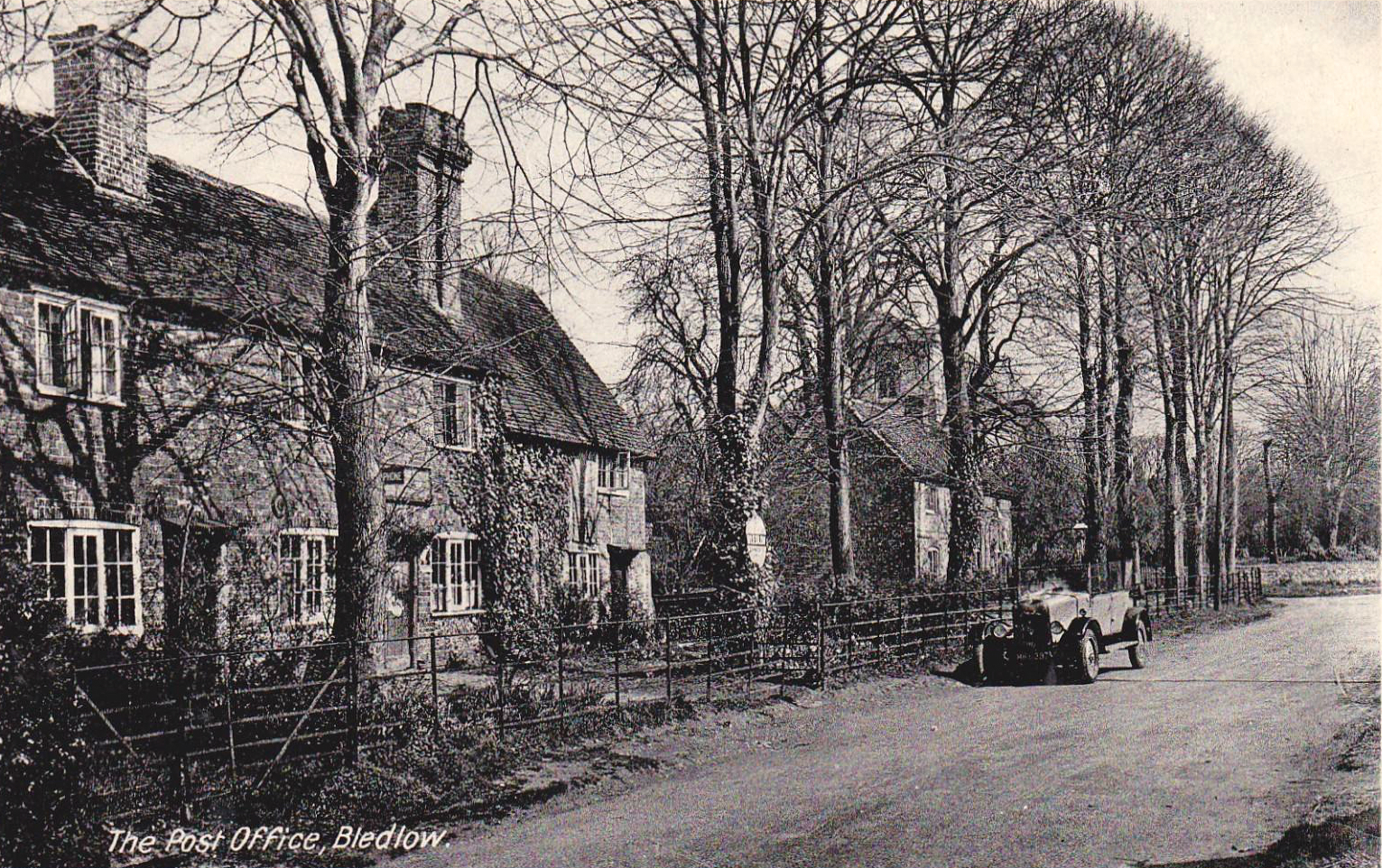
The Village of Bledlow is picturesque, its small Houses, surrounded by Gardens, lying for the most part along the side of the Hill, but there are outlying Houses in the lower ground on the side Roads which join the Icknield Way. Near the Cross Lanes Junction Leading to Skittle Green stood the Three Crowns Pub on the Northside of the Lower Icknield Way (Closed 1957).


The Three Crowns was on the Chinnor Road. It closed in 1957 when the Landlord died. He had married & reputedly, put his wife to work in the Bar from their Wedding Day until his Death. She closed the Pub when he Died & carried on Living there until she Died in 1999. Possibly the Building has now gone & the Site Redeveloped.


The Seven Stars was situated on Sandpit Lane. This Pub is now a Private House known as The Old Seven Stars.

My Family lived in the Seven Stars, now the Old Seven Stars in Bledlow, Bucks, on Sandpit Lane from about 1954 to 1956/7(?). I was in Bledlow Primary School for a few years before we moved to Lacey Green Area. I remember one year the Cellar Flooded where there were Trestle Tables & some empty Barrels that floated nearly to the Top. The Road outside was Flooded too. The Lean-to housed the Copper & a Bath. The Gents Toilet was attached to the side & the Ladies Toilet was a Brick Edifice down the small narrow Garden. It gave onto the Railway & twice I remember Trains going through the Gates smashing them. The Bench Seats were still in the Lounge Bar area & a Double Door halfway down which was the Serving Hatch for Beer I presume. We only lived in it as a House. The Publican lived in a Room at the back & there were several Bedrooms Upstairs. My brothers & I played in the Loft which was over the Carriage House where there were Hay Containers for Horses in the old days. The Farmer Mr Walker opposite used to provide a big Bonfire on November 5th. The Chimney was set alight one year & we put Snow on it. The Station Masters Home was opposite & the Road led to a Mill, a Paper Mill I think. Now the Railway is gone and the Road paved over. Frances Topping (July 2022)


This was Established from the 1812 Enclosure Awards Map by plotting the smaller Holdings into which the Big Fields had been Subdivided, still Listed as part of North, South & West Fields. Pastures & Meadows such as Hen Field, Perry Field, North & West Meadow were also Identified, as well as Vineyard, Locally held to have been a Hop-garden & the small Strip immediately to the South of the Lower Icknield Way, near Monks’ Mill, known severally as Hangindeforlonge (1298), Hangfurlong Close (1742-44) & Hanging Close (1812). Coneygra, shown as a Chalk Pit on the 6-inch Map, must surely be a Norman Survival, when every Manor maintained a Rabbit Warren (Coneys), while Haydons may well equate with the Headland called Haydoneshaeht, the perquisite of the Bledlow Hayward in the Custumal of 1248. The Group of Smaller Fields, to the North of the Lower Icknield Way, unnamed on the Plan, were the “Closes” or Enclosures related to the Cottages, which are mentioned in Parson Taylor’s Tithe Book of 1742-48 where names appear such as Killepins, Black Worges, Costard’s Piece, Neighbour’s Close & The Lotts, possibly a Survival of Strip Cultivation when Lots were drawn for Shares in the Common Fields. Some of these are quoted in the 1812 Enclosure Awards List. The Icknield Way appears frequently in Documents relating to Land Tenure; an interesting rendering of the name is found in the following Grant of Tithes to John Heybourne dated 1685 “in the Common Fields, Upper Northfield, Middle Northfield & Lower Northfield & Tithes in Closes lying below the Highway called the Lower Acknell Way alias Hackney Way“. The name Heybourne occurs frequently in Church Documents & in Parson Taylor’s Tithe Book, which also mentions Gomme, Sale & Tappin, Families still known in the Bledlow of today.
Bledlow Land Tenures & the 3-Field System – Alison Young, FSA

The Queen Public House was on Longwick side of Perry Lane. In the early part of the 20thC, there was a strong Temperance Movement in England. It closed in 1938 and Compensation was paid under the 1910 Licensing Consolidation Act. The view that arose from this movement was that there were too many Public Houses compared with the needs of the Public. Brewers would pay a Levy, the Licensing Magistrates would select Pubs that they considered Redundant, not Renew the Licence and then pay Compensation back to the Brewer & their Tenant; typically, only about 10% went to the Licensee. This compensation was Paid for by a Levy on the Licences Granted to other Premises. It’s a Private House now.
Amongst the Vicars of Bledlow the name of Timothy Hall (1637?–90) occurs. He held the Livings of Horsenden, Princes Risborough & Bledlow in succession, being Presented to the last-named in 1674. Three years later he became Rector of Allhallows Barking. He Published the Royal Declaration for Liberty of Conscience in 1687 & the next year became Titular Bishop of Oxford. He was Consecrated, but the Canons of Christ Church refused to Install him. On the Accession of William of Orange he Refused to take the Oaths, but yielding at the last moment retained his Titular Bishopric until his death.


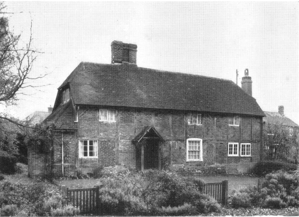
Public house. Lions of Bledlow – formerly the Jointly Attached the White Lion & Red Lion Inns – 17thC-early 18thC, dated 1654 AD on Brick according to Royal Commission on the Historical Monuments of England. Whitewashed Brick, the Centre Bay with remains of a 1st-Floor Band Course. Old Tile Roof, Brick Chimneys to left & to Right of Centre. 1-Storey & Attic, 5-Bays, the right Bay blank & a later addition. 3-Bays to left have paired barred Wooden Casements in Hipped Eaves-line Dormers. The Ground-Floor has irregular Wooden Casements, the Left an Oriel window, the centre with Canted Bay Window. A flush-panelled Door in Gabled Porch between left Bays, Board Door to right of centre, another in Gabled Porch between right Bays. Small 20thC Whitewashed Brick Extension to Left; large 20thC Block & other Extensions to Rear.


Between the Old Forge on the North Side and the Church is a House, once an Inn, which has Herringbone Brick-work in the Gable end.

The Old Vicarage – House. c.1830. Knapped Flint with un-knapped Flint Dressings; flanking Pilasters with Brick Quoins. Hipped Old Tile Roof, Brick Chimneys at each end. 2-Storeys. 3-Bays. 4-pane Sashes with segmental Heads & raised Flint 2-Storey surrounds. Centre of Upper Storey has Blind Panel in similar surround above 6-Panel Door with radiating semi-circular Fanlight. Wooden Lattice Porch with hipped Lead Roof. To right is a later 19thC Gabled Bay of Flint with Brick Dressings, Slate Roof & 2-Storeys of Sash windows, the lower Tripartite.

The Old Rectory (Church End) – House, formerly Vicarage. Mid-late-18thC, altered & extended late-19th & 20thC. Vitreous Header Brick with Red Brick Dressings & Ashlar Plinth. Moulded Brick Eaves, Brick coped Gables with coping rebuilt 20thC at North end. Rear Wall is of Rubble Stone with Brick Dressings. 2-span old Tile Roof. 2-Storeys, 3-Bays. East Front has 3-Pane Sashes with thick glazing Bars to 1st-Floor & late-19th-20thC Sashes below. Centre Ground Floor opening altered to narrow Sash. All Openings on this Front have Segmental Heads with painted Stone Keyblocks. South end has large external Chimney, Blind windows, later Sash to Attic & a 20thC Single-Storey Extension. North end has altered Sashes, 19th-20thC Canted Bay window to left & Door in Gabled Porch to Right. Late-19th-20thC 2-Storey Brick Extension to Rear.
Map of the County of Oxford, from Actual Survey, by A Bryant, in the year 1823. Inscribed by Permission to the Rt Honourable the Earl of Macclesfield, Lord Lieutenant & to the Nobility, Clergy & Gentry of the County.

This large U-shaped Building, at the East end of Church End, is known as Bledlow Homes, but was formerly the Parish Workhouse, Built around 1800 to House 180-Inmates. It later became the Wycombe Union School for Boys & Girls. The 1881 Census Lists about 56-Resident children aged between 5 to 15 under the Tutelage of the Master, George Roberts, with his Sister Rebecca who was the Matron. The Ordnance Survey Map of 1922 still shows the Building as Wycombe Union School.
An Agreement of 1582 to Levy a Fine mentions “a Watermill called Normill (North Mill?), alias Bledlow Mill to the use of Hampden Powlett“. Apparently the de Gurnay Descendants still owned the Normill though the Hampden Powlett, who Held Estates in the District (Corham’s Manor) Rented it.

While the present House, locally known as Monks’ Mill, post-dates the Dissolution of the Alien Priory, the Site must surely be that of one of the Watermills Granted to Bec in the de Gurnay Charter. The Millstones may be seen set in Paving at the Doorway. The Building is one of a group of 5–Tudor Houses, Timber-framed with Herringbone Brick-work, probably replacing Witchert Houses of an earlier date.
Opposite the Church on the Southside of the Main Street is a House with half-hipped Gable ends, Listed as The Mill House. This Mill must have been Horse Driven or a Windmill; the Millstones may be seen in the Courtyard.

Also on the Southside of the Road, farther West is another House – Church End with recent additions, but the Original built-out Bread Oven can be seen on the North Wall. On the Northside of the Main Street, a House known as Piggotts has been refaced, but the North Wall shows small 16thC Brick-work. There are Chamfered Beams within and an interesting Spiral Stairway with Wooden Newell Post. This Building was at one time used as a Forge.


The Lyde Brook had Springs rising in a Steep Wooded Ravine, Pool in the Village now the Lyde Gardens. There were 2-Watermills. One on the Cuttle Brook, the North Mill on Northmill Road near Sandpit Lane & the other Bledlow Watermill. The 2–Paper-Mills of Mr A H James provide Occupation for part of the Population. Also known as Bledlow Lower Mill or Lower Saunderton Mill, this Mill lies on the Cuttle Brook Stream. A large Building constructed of Red Brick, with areas painted cream, at the time of Stanley Freese’s Visit in about 1930 the Exterior had become disfigured by the Attachment of tarred Galvanised Ironwork. It was still in working order. In its life, the Mill had been used both for Grinding Corn & Paper Making. This Mill had an Overshot Waterwheel.
Bledlow Cum Saunderton Map

The Cop: Today the Burial Mound on the Hill overlooking Bledlow is almost hidden within the Trees, but when it was Built the Hillside was probably Treeless, Wood being in great demand for Huts, Equipment & Fire-wood. The Mound would have been higher, possibly surrounded by a Ditch which has since filled with Silt. Barrow Burials such as this are often Sited High in the Landscape, on the Sides of Hills with a good View (to be seen by the people living nearby, rather than for the Deceased!). Many of these Burial Mounds (often marked Tumuli on Maps) are early Bronze Age in date, but Anglo-Saxon and, less often, Romano-British Mounds may look very similar. The Cop is probably Bronze Age, from 4,600 to 3,600-yrs old, but some people think it Saxon (after 410-AD). The Saxons seem to have known the name of the Deceased (Bledda), so it’s possible.

Bledlow Ridge is a Village in the Civil Parish of Bledlow-cum-Saunderton in Bucks. It is situated in the Chiltern Hills, about 4-miles SSW of Princes Risborough & on the Road between the High Wycombe & Chinnor. Originally the Hamlet was within the Ecclesiastical Parish of Bledlow. It gained separate Status in 1868 when the New Chapel, dedicated to St Paul, was constructed. Bledlow Cum Saunderton Map
The Post Mill was of open-Trestle Design, with 3-Crosstrees & 6-Quarter Bars & had 4–Common Sails. Detailed measurements are given in Smith (1932, p. 130). It ceased Work in 1913 and was used as a Water Tower. By the 1930s it was in bad condition with only 1-Sail remaining. From Maps, we know that this Windmill was in existence by 1797. The Windmill was acquired by a Group of Speculative Developers called ‘The Land Company‘ before 1910. Around 1913 one of the Main Timbers of the Windmill broke & according to the Book there was a dispute over ‘Rights’ which meant Repairs were not carried out. Milling here ceased in 1914. By 1933 Wycombe Rural District Council had acquired the Site and they had the Windmill Demolished.
Reproduced from VCH Oxfordshire available Online at British History

