Brightwell Park, immediately North of Brightwell Village, was the Site of a Medieval Manor house remodelled in the late-16th or early-17thC & set amidst Formal Gardens. The Old Country House of the Lowndes Stone Family Burnt Down in 1786, but a Cruciform 17thC Dovecote that was some distance from the House survives in the Park.
Brightwell Baldwin Manor House (Brightwell Park) – The House to 1788
The Berefords’ & Cottesmores’ Medieval House almost certainly lay in Modern Parkland c.300M North of the Parish Church, at a Site identified by recent Archaeology. Its Origins may lie in a Free Tenement & New Garden held by Geoffrey Langley in 1248, and a Manor House existed by 1300 when a Robbery occurred there. In 1326 the Demesne included 2–Gardens & 2–Dovecots. The Lords’ Status suggests a well-appointed Residence which presumably incorporated a Great Hall & may have been arranged around a Courtyard with a Gatehouse. An excavated Building with Chalkstone Walls, detached from the Main Complex, may be the Chapel for which Sir Baldwin Bereford obtained a Papal Licence in 1397. The Chapels East End was mentioned in 1520 when the House had ‘Over‘ & ‘Nether‘ Chambers suggesting a 2-Storeyed Solar Block, while appurtenances included a ‘Watergate, Barns, Granary & Guest Stable‘.
Most post-Medieval Owners continued to Live at Brightwell & Archaeology indicates extensive remodelling for the Carletons or Simeons in the late-16th & early-17thC, creating a Grand Residence with an Ornamental Terrace & Formal Gardens. Building work was perhaps underway in 1632, when Lady Dorchester was forced to Live elsewhere. The surviving 2-Storey Dovecot, built of Limestone rubble with Ashlar Quoins & Brick Dressings on an elongated Greek Cross Plan, dates from that Period. The Dovecote has windows on the 1st-Floor & bird nesting boxes & ledges on the inside. In 1662 John Stone was Taxed on 30-Hearths. The name Brightwell House was Established by 1730 & a Private Chapel (perhaps the Medieval one) was noted in 1738. The clear Chalk Stream was dammed to create the Lake in the Park. The Brightwell Baldwin Estate passed through a number of Influential Families, among them the Cottesmores, the Parkes & the Carletons. In 1754, it came down to the Lowndes Stone Family, when Francis Lowe left it to his daughter, Catherine, who had married William Lowndes Stone in 1744. At this time, there existed an Elizabethan Manor House, although no Trace of it remains. Later in the 18thC the Park gained a Brick-built Icehouse & a Walled Kitchen Garden & some of the straight, tree-lined Carriage Drives running through the Park in the 1790s may have also originated in the 17th or early-18thC.
This Georgian successor was mostly Demolished c.1947-49, but its Kitchen Wing, Stables, Ice House & an 18thC Stone Arch Bridge in the Park survive., leaving the converted Stable Block & the early-19thC Landscaped Parkland.
The House since 1788
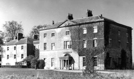
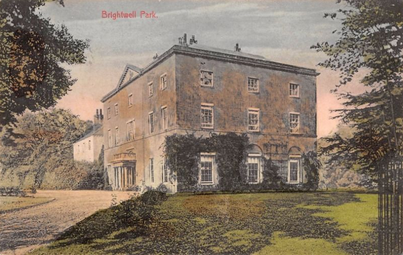
The Old House Burned Down & much of its contents were Destroyed by Fire in March 1788 & was swiftly replaced, in about 1790, by a new, Square, Stone-Built House, thought to have been Designed by James Wyatt for Lowndes Stone’s son, also named William. Within a few years, William Lowndes Stone had completed a New House on a Site c.200M to the West. Called Brightwell House or Brightwell Park, it was a Square, Classically-designed Building of 3-Storeys & 5-Bays, faced in Limestone Ashlar & featuring a Pedimented Central Bay on its Principal Façade & a Semi-circular Central Bay to the Rear.

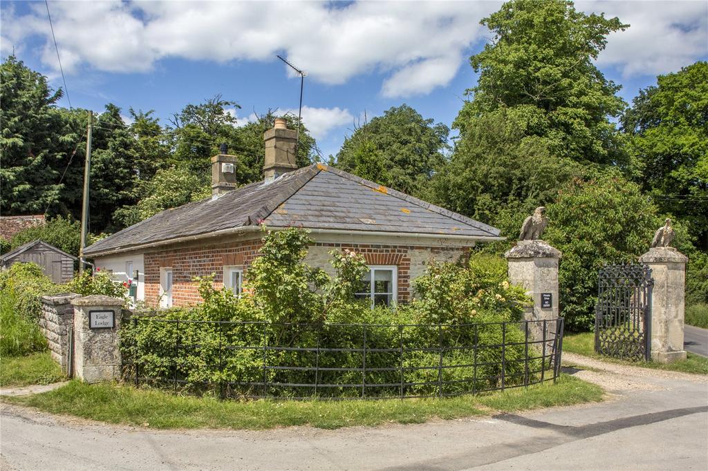
Vaulted Cellars lay beneath, & a Single-Storey (raised to 3-Storey’s in 1874) adjoining Service Wing contained Kitchens & Offices. An adjacent surviving Stable Block is in similar style, Built on a U-Plan. The surrounding Parkland was Landscaped in the naturalistic Style of Humphry Repton, to include an Ornamental Bridge known Later as the Waterloo Bridge & 2-Sinuous & Tree-lined Carriage Drives, each leading to Classical Lodges & Formal Gates. The Cedar Drive, lined with Cedar Trees, leads to the Ashlar-faced Cedar lodge, while the Eagle Drive leads to the Chalk-rubble & Brick Eagle lodge, where Limestone Eagles surmount the Gate Piers. Repton’s direct involvement remains unproven, although a Watercolour by him depicting Brightwell Park was Engraved & Published in 1797.
The Ice House, the 2 Grade-II-listed Georgian Lodges, the Bridge & the Kitchen Garden are all thought to date from that time. During WW2, the Mansion was used to House 2-Preparatory Schools, before being largely Demolished in 1947. The part that remains – the present Dower House – has been converted into 3-Flats, below which is a massive Ground Floor, unused for more than 70-yrs. The Grade-II-listed former Coach House & Stables that make up the present, 6-bedroom, Main Estate House, also known as Brightwell Park, form 3-sides of a Cobbled Courtyard separated from the Dower House by Garages with Courtyards to either side. Both the Mansion Ruins & the Dower House are unlisted. The Character of the Parkland, which slopes down towards the former Fishponds & the Stream that traverses it, reflects the 18thC Landscaping Scheme believed to have been Laid out by Humphry Repton often regarded as the successor to Capability Brown – although no Red Book exists.

Humphry Repton (1752–1818) was the leading Landscape Architect of his day, a Master of his Craft & an Expert in the Arts of Self-Promotion. Congenial, Witty & well connected, he circulated easily in the highest reaches of English Society, where he could recruit Wealthy Clients prepared to pay handsomely for his Advice. He presented his Plans to his Clients in the form of Red Books, thus named for their characteristic Red Morocco Bindings. A typical Album contains his Observations on the Present State of a Client’s Property & his recommendations on how it might be improved. He would compose an eloquent Account of his Proposals, which would be written out in a fine Copperplate hand. A number of Watercolour Illustrations would accompany the Text, some of them furnished with Hinged or sliding Overlays making it possible to compare before-&-after Views of the same Scene. Repton employed this ingenious Graphic device in 2 of his Red Books, both so fragile that they are hard to handle safely.
From the mid-19thC the Lords of Brightwell Baldwin lived elsewhere & in 1862 Brightwell Park was in Disrepair. The House was Leased & during WW2 Accommodated 2-Boys’ Preparatory Schools evacuated from London & Hampshire. 2-Storeys were added to the Service Wing in 1874, raising it almost to the height of the Main Block, but the House became increasingly Dilapidated & c.1947-49 was Demolished piecemeal, leaving only the 4-Ground-floor Walls & the former Front Door. Some Mahogany Doors & Oak Flooring were reused in the Stable Block, which was converted into the Principal Residence. The top 2-Storeys of the Service Wing, which was re-named Dower House, were converted into Flats, but the Ground Floor became disused and remained so in 2011 when a few Original features remained.


The present Main House, known itself as Brightwell Park, is a former Stables & Coach House converted to a 6-Bedroom, 4-Reception Room House. The Dower House has since been converted into 3-Flats. There is also a modern Farmhouse & 2-Georgian Lodge Cottages; one at each of 2-Gated Entrances to the Estate.
The area, comprising 75 acres of grazed Parkland, 21-acres of Woodland & 29-acres of Pasture, includes a mix of formal & informal Tree Planting, the crowning glory of which is a 200-yr-old Cedar Avenue that meanders through the Park & is reputed to be one of only 2 of its style & age remaining in the Country.

Stands of Trees are also found near Brightwell Park, where some form of Parkland may have existed in the Medieval Period. Formal Gardens laid out there in the 17thC were swept away in the early-19thC, when the Park was re-Designed in the English Landscape Style.

Brightwell Baldwin Parish c.1880
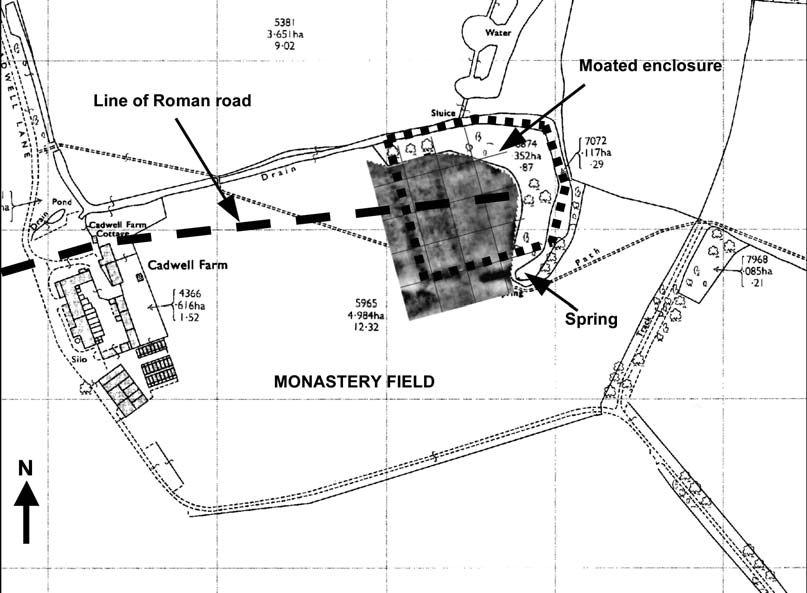
Cadwell Farm – Location of the Spring, Moated Enclosure & Roman Road in Monastery Field
The Moat is Fed by the Spring at the East end of Monastery Field & encloses a sub-rectangular area of about 0.6ha. Its size is fairly typical for Oxon Domestic Moated Sites, which vary from 0.3-0.8ha, as is its Location on the Spring Line, in this case where the Upper Greensand gives way to the Gault Clay Vale below the Chiltern Scarp. There is a raised Platform at the Western side of the Enclosure – presumed to be the Site of the Manor House. A Roman Road runs roughly East-West across the entire length of Monastery Field, passing just under the North end of Cadwell Farm House where the Line kinks to the South slightly & continues on towards Berrick Salome, following the Line of an Old Ride called the Slipe. The 1943 Aerial Photos show this Ride Lined with Ash Trees that were cut down shortly after for the War Effort. It was Ploughed out in the 1950s by the same Farmer who Levelled & Ploughed Monastery Field. Roman Coins were earlier recovered from the front Garden of Cadwell Farm by the present Owners. Eastwards, the Line of the Road is pointing towards the Old Ford across the Chalgrove Brook once known as Cadwell Ford & identified as the strætforda of the Anglo-Saxon Charter of Brightwell of 887, pointing to this having been a Roman Ford. The Roman Road is likely to have passed just to the South of the Spring, which must then have emerged slightly further North. Whatever hard surfacing the Roman Road once had (probably Gravel) has been Ploughed away from the area excavated but from the spacing of the Ditches either side we can be sure that it was a standard, Single Lane Highway about 8-10 Roman Feet wide (2.4-3.0M). From excavation of the South Ditch, we know that the Ditches were originally a standard Roman V-shape with slot bottom. This is suggestive of Military involvement which, if taken together with the early annexation of this area of Britain, probably points to a 1stC date. The North Ditch remained a V-Ditch but the South Ditch had later been re-cut on the Outer (South) side to create a Trapezoidal Ditch of about 3-times the capacity. This must have been in response to problems of runoff from the Slope. No Roman Finds were recovered from the Road but some fine Medieval Pottery was recovered.
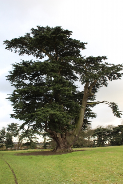
Giant Cedar: There is a short bole before the Spring of 3-gigantic Limbs. This gigantic Tree which may be one of the largest recorded Cedars in cultivation anywhere in the world and likely one of the largest Conifers in Southern UK by wood volume. The Tree stands in Brightwell Park, several 100M from the Village of Brightwell Baldwin This Tree was Planted sometime after Brightwell House was Built by James Wyatt in 1789. The Park is suggested to be Planted in the style of Humprey Repton, but there is no ‘Red Book‘ to suggest this. It stands within 10M of the Public Footpath. Brightwell Park rests on the Upper Cretaceous Upper Greensand, a soft calcareous Sandstone, known Locally as Malmstone, which produces a Fertile Soil. Not far away there are pockets of Lower Greensand on the ‘Oxford Plain‘ which produces a Fertile Acid Soil. The Tree is fairly healthy, despite some major Branch losses over the last 5-decades or so, no doubt due to Wet Snow & Gales. Thus the accumulated Wood Volume may have been larger than today. It is clear that the Tree in its early & middle years grew very fast in Wood Volume typical for the Species. The Girth was measured at the narrowest Point at 0.8M which was 10.86M. Another measurement was taken at 1M which was at 11.22M c.2017
Part of the Country was also Hunted in 1822 by Mr Lowndes Stone, of Brightwell Park. In 1824 & 1826 Mr Harvey Combe, then Master of the Old Berkeley Hunt (Glos), besides that Country, he also took over the South Oxfordshire Hunt, the Area at present Hunted by the Old Berkshire & South Oxfordshire Hunts, but at a later date handed over the Old Berkshire Country to Lord Kintore, the Hardest Rider of his day.


Lord Parker of Shirburn Castle Hunted the Countryside for 2-years until 1847, when he gave it up & Mr John Shaw Phillips succeeded him. His Lordship, however, now Earl of Macclesfield, after some years resumed Office, becoming Joint-Master with Col John William Fane, of Wormsley, in 1857 & the Joint Mastership continued for 3-Seasons. The Earl bought the Pack outright & his memorable Period of Mastership extended until 1884. The long Reign of the Earl of Macclesfield may well be called the ‘palmy days’ of the South Oxfordshire Hunt, for his Lordship was not only a particularly fine Judge of a Hound, but possessed a thorough knowledge of the Huntsman’s Art, while his Personality & Charm of manner ensured him such measure of popularity as falls to the Lot of Few. Until quite the latter end of his Mastership Lord Macclesfield Rode straight to his Hounds whether in the Woodlands, Vale or on the Hills – indeed his method of Riding through the Beech-woods in the latter District, with the Reins hanging Loose on his Horse’s neck, could only be copied by a man of Indomitable Nerve. The Kennels in Lord Macclesfield’s time were situated at Shirburn Castle, his Seat beneath the Chilterns & they were consequently a long way from some of the Friday Fixtures; in 1884 new Kennels were built at Stadhampton Green & the Pack has been Quartered there ever since. In addition to bringing the South Oxfordshire Pack to a high pitch of excellence, Lord Macclesfield planted several Coverts, notably Cornwell Gorse, more familiarly known as The Gorse. This Covert was one of the best in the Country, situated as it is in a Sea of Grass; & though at the present time the Gorse itself has vanished, strong growth of Blackthorn has replaced it & it is seldom that this Covert is drawn Blank. In the Earl’s time also a Covert was Planted by subscription at Kimble Wick on the extreme East of the South Oxfordshire Country. This, however, was subsequently claimed by the Old Berkeley (West) on the Ground that it had been planted on the wrong side of the Boundary; the Case was referred to the Masters of Foxhounds Association and was a subject of much discussion at Boodle’s Club (50-Pall Mall), until the Verdict was given in favour of the Old Berkeley. That Hunt at the present time looks upon Kimble Wick as quite their best Covert, standing as it does in the Aylesbury Vale and the Country round it forming a pleasant contrast to the Flinty Hills & Beech-woods which form the greater part of their Country. Lord Macclesfield had at one time an excellent Staff in W Grant & Harry Molyneux; Harry left to become 1st Whipper-in to Mr Garth & after spending a long time with that Pack was appointed Huntsman to the Burstow (Surrey). Two quicker Hunt-Servants than these 2 would be hard to find & during their Service with the South Oxfordshire the Sport was 1st-Rate.
The Kimblewick Hunt –The Hunt was formed in 2002 by the Amalgamation of the Vale of Aylesbury with the Garth & South Berks, themselves Amalgamations of the Garth, the South Berks, the Old Berkeley, the South Oxfordshire, & Hertfordshire Hunts in earlier times. It was renamed ‘The Kimblewick Hunt’ in 2010.
