
The small area with the letter ‘A’ is a detached part of Newington Parish in Ewelme Hundred. In the 19thC the Hundred covered 14,190-acres and was thinly Populated, having only 3,525-Inhabitants in 1841. It was composed of the Parishes of Pishill, Pyrton, Shirburn, Stoke Talmage, South Weston, part of Wheatfield & the Market-town of Watlington. The Ancient Trackway, the Icknield Way, running at the foot of the Chiltern Hills divides the Hundred into 2 & roughly separates the Highlands from the Lowlands. The Soil & Landscape are very varied: to the South-east are the Chalk Hills of the Chilterns, covered with Beechwoods & Rough Pasture; to the North-west, which is mainly Flat & Hedged, lie Clay Arable Fields & Meadows which, although there was much early Inclosure, were not completely Inclosed & Hedged until the 1st Decades of the 19thC. The Plain has always produced comparatively rich Crops: Arthur Young, to take one Observer, when crossing from Thame by way of Stoke Talmage to Goldor in Pyrton, noticed ‘much good Pasturage‘ & ‘very fine Open-field Arable‘. The Hills in the 19thC, though cultivated in parts, were chiefly used as Sheep-walks. The Hundred was wholly given over to Agriculture, for Watlington had no Industry of any importance & lived mainly by its Market, Shops & Inns.
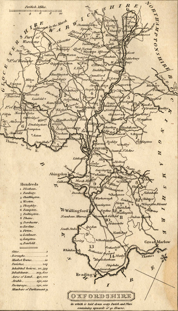
Map of Oxford County: Surveyed by a Local man, Richard Davis of Lewknor & Published in 1797. This Large Map consists of 16-Sheets at an impressively detailed Scale of 1:31,680 or 2in to 1-mile. No more than 200-Copies were ever made, the evidence is based on all Sets of the Map having Manuscript Serial No.s – this Image is part of No.34. Very few complete Copies survive. In terms of what the Map shows, a clear break has been made from the Saxton-led traditional County Map, as here far more detail than previously is featured. Not only are County & Hundred Boundaries, Rivers & Streams, Towns & Villages, Parks & Woodland depicted, but here we have Roads, Tracks, Hedges, indeed every Field can be seen, and relief is beautifully represented by the use of hachures. Davis was also Topographer to His Majesty, George III.

The beauty of the Countryside & its productive Soil have always attracted a number of Residents of means. In the 16th & 17thCs many of these Families, notably the Stonors of Stonor & the Chamberlains & Gages of Shirburn, were devoted Adherents of the old Religion & today Stonor is still a stronghold of Roman Catholicism. The Earls of Macclesfield in the 18thC made Shirburn Famous as a Scientific & Literary Centre & have since played a leading part in County Affairs.
The Hundred is distinguished in having 2-Medieval Houses of Historic importance, Shirburn Castle & Stonor Park, as well as the remains of a 3rd small Medieval Manor-House at Pishill. The Elizabethan Manor-House at Pyrton has also survived, but Lord Charles Spencer’s 18thC Mansion at Wheatfield was Destroyed by Fire in 1814. The Church at Wheatfield, remodelled in the 18thC, is also noteworthy.
There are many indications of Early Settlement & of Roman Occupation, but it is of interest for the number of Sites, some of which have not yet been located, of deserted Medieval Hamlets. Pyrton is one of the few Oxfordshire Hundreds named in Domesday Book, but the Hundred is 1st described in detail in 1279. There is no reason, however, to suppose that the Principal Villages comprising the Hundred in 1279 did not do so in 1086 or when the Hundred was originally formed. A calculation of the Hidage of the Villages in 1086 comes to 103-Hides, a close approximation to the normal 100-Hides. Pyrton was assessed at 40-Hides, Shirburn at 20, Stoke Talmage at 10, Watlington at 23, of which 3 were definitely stated to be in Watcombe and 2½ in Ingham (Adingeham), South Weston at 9-Hides & Wheatfield at 2. A striking point about these Hidages is that in many cases it can clearly be seen that they were Assessed on Estates that preceded the Parish. Pyrton & Watlington apparently divided Pishill between them; South Weston included Land assessed at 1-Hide in Wormsley & other Land in Wheatfield. Before 1106 Wormsley was alienated to Abingdon Abbey whose Chief Estate in this part of the Chilterns Lay at Lewknor in the neighbouring Hundred. It was probably, therefore, at this time that Wormsley was transferred to Lewknor Hundred. Otherwise, the composition of the Hundred remained unaltered until 1841.
Oxfordshire Map 1881– Adwell, Aston Rowant, Brightwell Baldwin, Brightwell Upperton, Cuxham, Easington, Kingston Blount, Lewknor, Postcombe, Pyrton, Shirburn, South Weston, Watlington, Wheatfield,
The Hundred, with the other 3½-Hundreds, was given away by the Crown and came under the Lord of Wallingford Honour and the Earldom of Cornwall in 1244, and was later attached to Ewelme Honour. The Earl of Cornwall was said in 1279 to have all Royal Rights & Liberties within the Hundred, and in 1285 he claimed specifically the Right to have Return of Writs, Gallows & Assizes of Bread & Ale. The Hundred Court & View were held at Pyrton under the Honour of Wallingford, but not all the Villages of the Hundred attended, for some were original Fees of the Honour and, therefore, owed Suit to the View of the Honour at Watlington. These Fees were Pishill Napper (i.e. one of the Manors in Pishill), the Baldon Fee in Watcombe in Watlington & Watlington itself with its Hamlet of Syresfield. By 1284 Stoke Talmage, which used to attend Pyrton Hundred Court, had ceased to do so, as the Earl of Cornwall had Granted View of Frankpledge & Suit to the Hundred to Rewley Abbey, which in turn Granted these Privileges in 1287 to Thame Abbey. Stoke Talmage, therefore, does not appear in the later Records of Pyrton Hundred.
Records of the 3-weekly Hundred Court and of the View which were Administered under the Bailiwick of Wallingford survive. The Annual View Court was attended by 4-Tithing Men from Shirburn, 2 each from Pyrton & Clare, and one each from Goldor & Standhill, both Tithings of Pyrton, one each from Pishill Venables (i.e. the other Manor in Pishill), Warmscombe, Watcombe (i.e. the Préaux Abbey holding in Watcombe), South Weston & Wheatfield. They paid cert ranging from 6d to 4s. The absence of a Tithingman for Assendon seems to be explained by the fact that Pishill, as on other occasions, includes the Tithings of Pishill Venables and Assendon: later records sometimes refer to ‘Pishill alias Assendon‘. Little Business was transacted at the 3-weekly Court or View by the 15thC: the Tithingman usually said that all was well or Presented a few Cases of Breach of Assize of Ale or Petty Assault, and in the year 1431-32 the Profits of the 17-Hundred Courts totalled only £1-16s-11d. The View of Frankpledge Court held in April 1432 collected 16s-5d Cert Money and 8s in small perquisites. In the 16thC, the views seem to have been reorganised and the Court was held jointly with Lewknor. On several occasions, it was held at Shirburn, but later at Lewknor down to the 19thC.
Assendon Tithe Map 1850
By the 17thC, the Hundred was divided into a North & South division. The North consisted of Clare, Goldor, Standhill, Stoke Talmage, South Weston, & Wheatfield, and the South of Assendon, Greenfield, Pishill, Pyrton, Shirburn, & Watlington. The Chief Constables were Yeomen, Watlington Traders, & Gentry.
As an Administrative Unit, the Crown used the Hundred in various ways, notably to collect Taxes, to regulate Alehouses, place Apprentices, and see to the Keeping of Watch & Ward and proper provision of Poor Relief. Its use to control Vagrants is seen in 1600 when the 2-High Constables reported that they had kept Watch & Ward on the Night of 1st November and the day following, but that nothing had happened. In 1639 a number of Owners & Tenants of the Hundred, ‘aggrieved at the Surcharge‘ on the Hundred for Ship-money, Petitioned the Privy Council.
Ship Money was a Tax of Medieval Origin levied intermittently in the Kingdom of England until the middle of the 17thC. Assessed typically on the Inhabitants of Coastal Areas of England, it was one of several Taxes that English Monarchs could Levy by prerogative without the Approval of Parliament. Charles needed to raise money without Parliament so he used Old Laws such as Ship Money, which was a Tax collected from Coastal Towns in the Middle Ages to Pay for the Navy. In 1635 Charles made Inland Counties Pay it too. The MP John Hampden refused to Pay in 1637. Charles also found a forgotten Law that said that anyone earning more than £40 a yr had to be a Knight. In 1630 he started Fining people who had not Obeyed.

Pyrton Drift Way
The word Drift is an alternative to Drove and occurs most often in East Anglia – but we have what was known as the Pyrton Drift Way in Oxfordshire. On Modern Maps it is now known as the Oxfordshire Way, a Long-distance Footpath that has suitably taken over the Mantle of an old Route. It has been suggested that although the Route was used by local Farmers in the Vale to move their Animals on to the Escarpment in the summer at Christmas Common & Turville Heath, it was also used by Long-Distance Drovers coming from Worcester via Chipping Norton, Islip & Wheatley. Instead of following the Line of the A40, they cut diagonally across the Vale by way of Haseley to Pyrton via what is now the Stoney Lane Bridleway & Knightsbridge Lane and the Base of the Scarp. The obvious Route up the Scarp is by way of Watlington Hill, which leads directly on to Christmas Common & Northend (to the South-east) where there were Commons, large Ponds & Pubs. Here they might have taken one of 2-Routes, possibly from Christmas Common via Hollandridge Lane to Stonor and then Henley with its River Crossing & Markets. The other possible Route was from Northend via Turville Heath along Drovers Lane to The Drovers Pub at Southend (now closed) and down the Hambleden valley to the River Thames.
Southend Common is located in the Parish of Turville, set on the Plateau Top above its parent Village. It is one of a run of Heathland Settlements, which includes Northend & Fawley Green. The key characteristic of this Settlement is the Open Common at the heart of the area. This is enclosed by a Range of traditional vernacular Cottages to the North and East. Further South the presence of Woodland. Buildings are hidden along small Tracks that cross into the Woodland. To the West of the Main Road lies the large former Drovers Inn, a fine Flint faced 18thC Building which provides a contrast with the Cottages opposite on the Common.

Why would they do this? – to avoid Tolls is the obvious answer, and to avoid the Town of Wycombe and its busy Stream with its Mills. They may also have earned Rights of Passage. The route avoids the Town of Watlington by crossing the main Road and joining up with the Icknield Way, the section directly below Christmas Common. This short stretch has one hedge on just one side of the Track – but this is dense and thick and very wide, and a distinct Barrier to the Fields behind. It is full of wildlife and is a pleasant walk in the summer. Drove Routes had hedges to avoid contact with local Livestock, but Tracks through Land without animals did not necessarily require a hedge – hence the single example. Local Drove Routes up from the Assendons to Southend & Summerheath, or from Lewknor & Chinnor, occur all the way along the Scarp in Oxfordshire. Anyone of them could have been adopted by the Seasonal Welsh Drover. Steep Hills presented no problem as the Cattle were reared in a Mountainous Landscape. Lots of possible Routes can be visualised – but this is where the guesswork comes in. Lots of people can find Intimations of Drove Routes anywhere in the Chilterns, and suggestions would be welcome.
Reproduced from VCH Oxfordshire available at British-History online
