
Settlements & Buildings – Prehistoric to Roman: Finds and occupation evidence fit a general pattern for this part of the Upper Thames Valley, which saw intensive activity from the Palaeolithic onwards. Excavated Neolithic Settlement by the River (close to Benson Church) was probably occupied by part of a wider Pastoralist Population responsible for the area’s numerous Monument complexes, which included a Cursus (large Parallel Lengths of Banks with external Ditches) and a possible Oval Barrow within the modern Benson Airfield. The same Riverside Site saw successive Bronze-Age and Iron-Age Settlement subsisting on mixed Farming, with comparable Ooccupation further North near the Berrick–Warborough Boundary. Finds suggest similar early Settlement around Littleworth, and possibly South of Crowmarsh Battle Farm.
Any remains of this once Sacred Site are now beneath the Airport between Benson & Ewelme, a couple of miles Northeast of Wallingford, on the Eastern side of the River Thames. A great pity. It was one of the early Cursus Monuments discovered as a result of Major G W Allen’s many Aerial Surveys in Southern England and subsequently described in Mr Leeds’ (1934) Antiquaries Journal Article. A cluster of Cursus Monuments were built in this part of England in Neolithic times, and Roy Loveday includes the Benson Cursus as an ingredient within the ‘Sacred Landscape’ Region of what he calls “the Dorchester-on-Thames Complex.” The Benson Cursus & surrounding Regional Monuments.

“in fact possesses features that would declare it as an inter-Regional Sanctuary if encountered in an Historical Setting; namely, Intensity of Monument Construction, longevity of respect, addition of later exotic Monuments with far-flung Parallels, large numbers of Burials, and placement in a Landscape structured, partly at least, by other Monuments.
No Entrances could be found into the Monument apart from a small Section along the Northeastern Length of the Structure (left). From its Southernmost Point, this Giant Monument runs along a SSW-NNE Alignment — one echoed in other nearby Cursuses — for 1192-yds (1090M) and is 71-yds (65M) across, covering 7.3 Hectares in all. No Internal Structures were noted anywhere within the Monument.
Roman Rural Settlement seems to have been widespread, focused on low-status Farming Communities set within a managed Landscape of Fields, Enclosures & Drainage Ditches. A 1stC Site on the Modern Village’s Southern edge proved relatively short-lived and saw successive reorganisations, but Occupation Sites on the Berrick-Warborough Boundary continued into the late-4th or early-5thC, and included Corn-drying Kilns. Further Roman Settlement probably Lay around the Eastern end of modern Brook Street close to an area called Blacklands, while Coin Finds and a possible Roman Enclosure have been noted on slightly higher Ground near Gould’s Grove, close to the Roman Road.
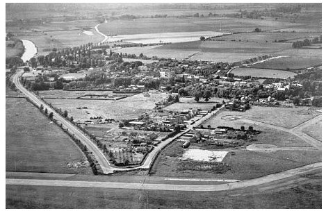
The Development of Benson
Anglo-Saxon Benson Benson Village occupies a Gravel Island by a Bend in the Thames, 5-km East of Dorchester and 2.5-km North-East of the 9thC Fortified Burh at Wallingford. Written sources suggest that by the late 8thC it formed an important Royal Estate Centre with a significant Strategic Role in the contested Border Zone between Mercia & Wessex. Bishop Forthhere of Sherborne may have witnessed a Royal Grant there between 727 & 736, and in 779 King Offa of Mercia reportedly recovered Benson from Wessex during a Military Campaign. The Evidence is not contemporary and may not be wholly reliable, but subsequent Land-Grants confirm its 9th-& 10thC Status as an important West Saxon Royal Possession with a large dependent Territory. The Anglo-Saxon Chronicle’s account of a West Saxon Victory at Benson in 571, though probably largely Mythic, similarly reflects the area’s importance when the Chronicle was being compiled in the late 9thC. A key factor in Benson’s early Emergence as a Royal Centre was presumably its proximity to the former Roman Town of Dorchester, where King Cynegils of Wessex was Baptised c.635 in the presence of his Overlord King Oswald of Northumbria, and which subsequently became the area’s Chief Ecclesiastical Focus.
Archaeology confirms an early-to-mid-Anglo-Saxon presence in Benson, with possible Foci in the South-west near St Helen’s Avenue, and further East around Brook Street. The excavated St Helen’s Avenue Site (100M South of Benson Church) revealed 6th-to 8thC occupation including sunken-featured Buildings, and a comparable Site may be recalled in the place name Littleworth, for a fringe area on the Village’s Northern edge. Finds suggested only modest Rural Settlement, however, and no Archaeological confirmation has yet been found for a Royal Residence or high-status Focus, despite recent speculation regarding an excavated feature South of Benson Church, and despite earlier claims for an Enclosure (now under Housing) between the Church and the River, where finds of Bones & Weapons were reported in the 18thC. A late-Anglo-Saxon Royal Residence may, however, have Lain outside the Main Estate Centre near Newington, where a Site called Kingsbury (‘King’s burh or fortified enclosure’) belonged to the Royal Estate until c.1155, and included a Walled curia. Firm evidence for an early-Church at Benson is similarly Lacking, although in the Medieval Period Benson claimed residual Parochial Rights over much of the former Royal Estate, suggesting a pre-Conquest Church of above average Status. Recent work also suggests that Benson’s Topography may preserve traces of late-Anglo-Saxon Grid planning, of a type lately proposed for many other Sites during the Period. The place name Bensington (gradually shortened to Benson from the 16thC) means either ‘the tūn of Banesa’s Folk’ (suggesting an early Established Anglo-Saxon Settlement), or, more likely, ‘Banesa’s tūn‘. If the latter, Banesa’s identity & date remain problematic, unless he was an unrecorded Royal Tenant.
Benson itself was Set within a wider Landscape shaped by the Royal Estate, with the putative King’s Burh and a dependent Farm or Berewic (Berrick)to the North, the likely Hundredal Meeting Place to the North-East, and a possible Trading or Tax Collection area suggested by Coin & Metal finds on the edge of Ewelme Parish. To the West, Warborough (‘Watch Hill’) may have fulfilled a protective function for the Royal Centre, while undated Burials reported at Gallows Leaze, on the Warborough–Benson Boundary, may reflect an Anglo-Saxon Execution Cemetery. Over all, what constituted ‘Benson‘ in the 8th or 9thC probably encompassed a Complex extending way beyond the Modern Village.
Medieval & Later Development: In 1086 Benson remained the most valuable Royal Estate in Oxon, but despite its early importance it failed to develop Urban Characteristics, overshadowed at 1st, perhaps, by the important Ecclesiastical Centre at Dorchester, and from the 9thC by the new Royal Burh at Wallingford and other emerging Market Centres. How late any Royal Residence was maintained is unknown: no late-Saxon or post-Conquest Kings are known to have stayed there, and from the mid-13thC the Manor was frequently held by High-Status non-Resident Lords whose Local Power-base was Wallingford Castle. A broadening of Benson’s Main Street at what is now Castle Square (where there is a pronounced Dog-leg) may hint at a small pre-or post-Conquest Market area, but no Market Grants are recorded, and by the 13thC Benson was a predominantly Agricultural Village, albeit with a relatively broad range of Crafts.

Evidence for Benson’s Medieval Topography (the Church apart) is mostly lacking, but the main Elements were Established by 1638 when it was partly Mapped. As later, the London Road Dog-legged through the Densely built-up Village Centre past the White Hart & Red Lion inns, continuing down Mill Lane. An alternative Route ran down the later London Road a little further East, adopted as the Turnpike Road in 1736.

Church Way (so called by 1788) ran Westwards past the Church to Crowmarsh Lane & the River Thames, while modern Chapel Lane (already partly Built on) ran Northwards to the Open-fields. Late-Medieval Buildings survive near the parallel Crown Lane (named from an 18thC Inn), on High Street, and possibly near the top of Old London Road, while 16thC Buildings in the Village Centre include part of the large former farm complex at College Farm. Brook Street, running alongside the Stream from Ewelme, may have also been partly built up in the Middle-Ages: Exeter College’s Farmstead at its Eastern end (near Fifield) existed probably by the 1480s, and in the mid-18thC several Houses lined its North side, with a few others South of the Brook. Littleworth Waste, a Strip of Land on Benson’s Northern edge, had Cottages on its Southern side by 1708, although most existing Buildings there are later. A Village Pound reportedly Stood at Littleworth’s Eastern end, with the Stocks nearby.

18thC rebuilding & refronting altered the Village’s appearance but not its basic Layout, the rising Population being apparently Accommodated through subdivision, increased infill, and (by the 1840s) the Development of a few Cottage Rows & Yards. The mid-to-late 19thC saw some small-scale new Building at Oxford Road (Site of the new Village Schools), Littleworth, and the area in between, but in the 1930s the built-up area remained little expanded, interspersed with several large Open Spaces (including Allotment Gardens) in and around the Village, and with a few Larger Houses (chiefly but not exclusively along Brook Street) still occupying their own Grounds as in the 1840s. Small-scale expansion along the Old London Road and near Hale Farm began before WW2, but only in the 1960s–70s was there substantial growth, with intensive Housing Development on the Village’s Northern fringe and in the angle between the Old London Road and St Helen’s Avenue. The Northern Development incorporated Playing Fields and a New School, and a large Village Hall was opened nearby in 1988. Changes within the Older Village included Demolition of College Farm’s Street-side Barns c.1962 and their replacement by a nondescript row of Shops, set back behind a featureless Parking Area.

Later proposals prompted Local Protests and, eventually, creation of a Conservation Area in 1995, retaining much of Benson’s Historic Character. The Waterfront was developed for Recreation from the 1940s, when the former Wharf was bought for conversion into a Bathing & Boating Station and Rivermead Gardens were Laid out by the Parish Council. By the 1980s there was a Cruiser Station, Marina & Caravan Park, largely separated from the Village by the busy A4074.

One of the Village’s few surviving Medieval Houses is No.1 Brook Street at the bottom of Crown Lane, a small Cruck-Framed Dwelling of relatively primitive construction encased in banded Clunch Rubble & Brick in 1747. The structure retains Smoke Blackening from an Open Hearth, and remains of a Cross Passage. The slightness of its Timbers (replicated in re-used Medieval Fragments in the Loft of No.20 Old London Road) has prompted speculation that good Building Timber was in short supply in Medieval Benson.

No.1 Brook Street, once known as ‘Crossways’ is 2-Storey, Built in Ragstone and Flint in Bands with Brick Dressings & a Clay Tile Roof. The main Building incorporates ‘Cruck Frame’ in the Eastern Gable. This framed & pinned Truss was carefully exposed & preserved by Peter Aldridge and may be 16thC or earlier, making the original Structure one of the Oldest in the Village. The present House has remained virtually unchanged since re-Building in 1747. There are various Bricks carved with Initials & Dates. From about 1800 the premises were used as a Beer House until 1864 when Henry Munday used the right hand Front Room for the making and repair of Harness & Saddlery. His son, Edgar John Munday continued this Business from 1903 until 1911 when he became Post Master and used part of the High Street Post Office as his Workshop. (below)

Mr Alfred Halliday, who was a retired Naval Officer Purchased the No.1 Brook Street Premises in 1922, Built Workshops at the rear and set up Business. He installed Petrol Storage Tanks & Pumps (1st in the Village) and repaired and Serviced Motor Vehicles of all types. He was renowned over a wide area for his knowledge & skill for installing, repairing & servicing Marine Engines for the ever increasing Motorised Traffic on the River Thames. William Aldridge, Purchased the House, Workshops and Land to the Rear, No.3 Brook Street, and ‘Orwell’ in Crown Lane from Mr Halliday in 1944 for just under £2000. He continued the Business with a Manager & Staff until his son Peter and his wife Dorothy took over in 1969. The Workshop was Sold to a Motor Body Repair Specialist in 1977 and the Petrol Pumps removed because new Government Regulations controlling the Siting & Use of Petrol Storage Tanks could not be met.
High-quality Local Building Stone was also largely Lacking, however, and many of the Villages Medieval Houses may similarly have been Timber-framed. If so their loss presumably reflects large-scale Rebuilding during Benson’s later periods of prosperity. 16th & 17thC Timber Buildings (all Box-framed) include Brook Cottage, & College, Castle & Brook Farmhouses, of which College Farm (now rendered) passed to Magdalen College, Oxford, with a substantial Freehold in 1569–70, and subsequently acquired a Timber-framed Parlour & Chamber Wing. Its large adjacent Barns fronted the Main Street, and similar Farmyards formerly adjoined most other large Farmhouses in the Village, reflecting the prosperity of Benson’s emerging Yeoman Farmers.

An Exeter College Tenant was required to erect a Chimney in 1553, and Chambers over former Open Halls are Documented from the 1580s. Inserted Brick Chimneys at 28-High Street & College Farm culminate in Diamond-Shaped Stacks intended for Show, while surviving internal decoration includes an early-17thC painted frieze & false painted graining around the Boorway at Brook Farmhouse, superseding the painted cloths mentioned in an unidentified House in 1588. Up-to-date Lobby-entrance Plans (grouped around Central Stacks) were being introduced by the later-17thC, while the former Farmhouse at 74–76 Brook Street incorporates end-Stacks and a Central Stair Tower facing the Road, flanked by Outshuts which probably provided Cool Storage. The House’s End Walls are of Stone Rubble, which thenceforth became more common. 17thC Probate Documents point to adoption of Parlours and increasingly elaborate Furnishings by better-off Yeomen & Gentry, of whom some occupied houses Taxed in 1662 on between 6 & 11-Hearths. Nevertheless a 20% of Householders in the 1660s still had only 2-Hearths, while 38% had only one.

The partly Timber-framed Red Lion Inn was successively remodelled from c. 1680–90, beginning with a fashionable Brick-&-Stone East Front, and culminating by 1752 in a gently curving ‘Brick Showpiece’ along High Street, featuring Sash Windows, a Parapet, and blue/grey Headers with Red Dressings . The Crown was refronted in Brick & Stone in 1709, while the King’s Arms was adapted from 2-former Cottages before 1727 and remodelled in phases, acquiring a striking Semi-circular Brick-built Corner Tower which, between 1750 & 1779, prompted its renaming as the Castle Inn. Rounded corners facilitated access to the Rear Stable Yard. Several Private Houses acquired similarly fashionable Frontages alongside more humble rebuildings in Stone & Thatch, while in the late 18thC & early-19thCs compact Villa-style Dwellings in their own Grounds were built for aspiring Gentleman Farmers or Tradesmen. Of those, Paddock House South of Brook Street (Grey & Red Brick with a Welsh Slate Roof) was owned in 1841 by the Farmer Edward Shrubb, while Kingsford House & Colne House belonged to the prominent Powell Family, Coachmakers, Innkeepers & Landlords. The latter passed through marriage to the Lawyer Henry Corsellis, whose relative Nicholas (a Surgeon) occupied another Villa off Brook Street. The final Inn refurbishment was that of the White Hart, remodelled in the 1830s with a Grand 3-Storeyed Stuccoed Front of 8-Bays, a delicate Ironwork Porch, and a (now lost) Carved Hart facing the Street.

The Crown Inn, was situated on the corner of the Old London Road & High Street, was ideally placed for offering Hospitality to Travellers in the days when Benson was an important Stop for Stage Coaches. It has a date Plaque of 1709, but the Building is 17thC and Timber Framed. The Outbuildings behind the Crown form an L-Plan, with the Rear of No.48 High Street on one side, and a Barn forming the other. Newspaper Advertisements show that the Inn had stabling for 16-Horses in 1830, when William Costar was the Innkeeper. The Trade Directory for 1839, (see below) shows that 3-Royal Mail Coaches departed from the Crown Inn daily. In 1842, William’s brother, Richard Costar, was the Innkeeper and Advertised that he now had Stables, Harness Room and a Lock-up Coachhouse. The main Coaching Road originally entered the Village from the London direction via Coach Way & Mill Lane, but was re-Routed along the present Old London Road and down the High Street so as to avoid the marshy nature of the ground around the Mill Stream. This change advanced the prosperity of The Crown, and the decline in popularity of The Red Lion (on the corner of Mill Lane & High Street).

It is clear that associated Yards were providing Services such as Shoeing Horses and repairing & even making Coaches. The 1841 & 1851 Census Returns and the 1841 Tithe Returns show that a Coach Maker, Robert Verdon was living in the Cottage at the High Street end of the Stables, and that 2-other Coach Makers and a Carpenter were Living in the immediate vicinity. There was a Blacksmith operating immediately across the Road at the Plough (Wisteria Cottage) and several more from the Cottages down Old London Road. The 1897 Morland Documents refer to the Crown Inn with Coach House, Messuage & Workshop. At the Peak of the Coaching Era, in the early-19thC, Crown Square would have been a hive of activity.

Labourers’ Accommodation was increased partly by Subdivision during the late 18th & 19thCs, though some small Cottage Rows were built on High & Brook Streets, and from the 1770s to 1870s Littleworth was built up piecemeal with Cottages & Cottage Terraces, of which several bear initialled Datestones and may have been speculative Developments. Some are remodellings of earlier Buildings and variously feature Stone or Clunch, Brick, Thatch, Tile, and Welsh Slate. Additional Cottages were created in Birmingham Yard south of Castle Square, adjoining small-scale Industrial Premises including a Wheelwrights‘ & Smithy. New 19thC Institutional Buildings included the National & British Schools (1851), new Vicarage House (1869–70), and Congregationalist Free Church (1879), all of Brick or Flint. A Timber & Corrugated-iron Congregationalist Hall was built on Watlington Road before 1903.
Modest Red-Brick Terraces at 5–11 Brook Street and on Chapel Lane are dated 1905 & 1911, and in the early-20thC the Pioneering Meteorologist William Henry Dines (d.1927) Built a Small (now-demolished) Observatory next to Colne House. (He also lived at Pyrton House near Watlington from 1906 to 1913, and at Colne House in Benson from 1913 to 1927). In 1913, Dines Purchased and moved to Colne House. He christened his home Observatory House because he was one of 3-Generations of his Family who were Meteorologists and contributed much to the advancement of British Meteorology from the 1870’s until WW2. Much of this work was done at Benson. Being of Independent Means, after taking a Mathematical Degree at Cambridge, he was able to devote most of his life to the pursuit of his hobby, Meteorology. He became well known early in his Career from his Invention of the Pressure Tube Anemometer which was adopted as the Standard Instrument for measuring the Wind in this Country and was used also in many places abroad. Later he became even better known for his exploration of the Upper Air, 1st by means of Instruments carried by Kites and later by Small Balloons which reached a height of 10 or 12-miles before bursting and allowing the Instrument to return to Earth. He pursued this work at his Home in Pyrton House near Watlington and later during his Residence at Benson. In recognition of his work he was elected a Fellow of the Royal Society in 1905, an Honour much coveted by British Scientists. He was also a Fellow of the Royal Meteorological Society and served on its Council for many years, being elected President for 2-Terms of Office. His reputation was International. He was of a retiring nature and though well known in London scientific circles he did not take much part in Village life or Local Affairs. When Dines died in 1927, his effects were Auctioned and 1 of the 2-wooden buildings clad in corrugated Iron was sold to Bert Briggs, who lived in Mrs. Bloomfield’s present house. The Building is apparently still there. Observatory House was demolished in 1972 and the Development, which replaced it, was named Observatory Close.

Otherwise there was little new Building until the 1930s, when the Parish’s 1st Council Houses (featuring period Designs & ‘Tudor’ half-Timbering) were Built near Hale Farm. More standard post-War designs (by Harry Smith of Oxford) followed at Sunnyside, grouped around a new Recreation Ground. Private Development accelerated from the 1960s, with new housing built around St Helen’s Avenue from 1958, at Blacklands & Westfield Road from c.1966, and off Brook Street (partly replacing Demolished Buildings) from 1965 and in the 1970s. Much is in standard 1960s Style, though some later designs attempted, with varying success, to echo traditional materials & features. As elsewhere, some surviving Agricultural Buildings were converted into Houses.
