Until 19th & 20thC Boundary changes the Ancient Parish of Rotherfield Greys stretched for 6-miles (9.6-km) across Binfield Hundred, from the Chiltern Hills in the West to the Thames in the East. The Parish is mostly Rural, although parts of Henley extended into its Eastern edge from an early-date & in the 19th & 20thCs Suburban growth there expanded rapidly over former Farmland. Otherwise, Settlement is scattered, comprising Isolated Farmsteads & widely spaced Hamlets set around Greens or at Road Junctions.

Greys Court, the imposing Ancestral House of the Lord of the Manor from the 11thC, occupies a secluded position on Rising Ground 2-miles (3.2 km) West of Henley. The Greys were Landholders on a significant Scale, and the House became a major Aristocratic Seat & a Symbol & Focus of Local Power. The Western part of the Parish, which later became the Parish of Highmoor, formed a largely separate Community, and from the 15th to the 19thC belonged to the Stonor Family. The suffix ‘Greys‘, from the Chief Medieval Owners Descendants of the Norman Knight Archetil de Greye, was added to the Place Name from the Middle Ages, distinguishing it from neighbouring Rotherfield Peppard; earlier it was briefly known as Rotherfield Murdac, from a late-12thC Lord.

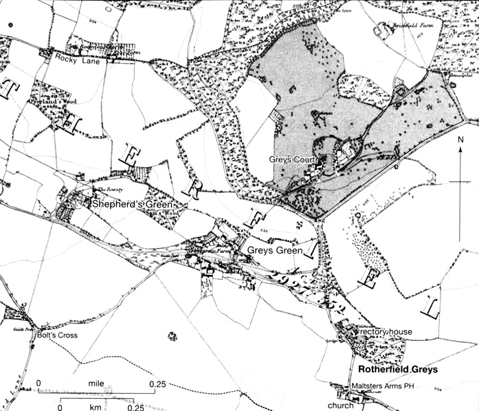
Parish Boundaries – The Parish’s elongated shape encompassed a variety of Agricultural resources, from the Wood Pasture of the Chilterns to the Waters of the Thames. Almost certainly that reflected conscious planning when Rotherfield was separated from the large Royal Estate of Benson before the Norman Conquest, although on later evidence Rotherfield Manor encompassed only the Parish’s Eastern part, as far as Shepherd’s Green. The areas further West (including Highmoor, Witheridge Hill & Padnells) were presumably Incorporated into the Parish by the 12th or 13thC, as Ecclesiastical Boundaries crystallised. In the 19thC the Parish’s (& County’s) Eastern Boundary followed the River Thames, while that with Henley ran along Friday Street & the Town Ditch before pursuing a partly undefined course North-westwards through Inclosed Fields. Much of the Wooded Northern Boundary, with Bix & Nettlebed, followed stretches of the Iron-Age Earthwork known as Grim’s Ditch. The Western boundary, with Nuffield, Newnham Murren & Mongewell, lay along a Valley called Stony Bottom, before turning South-eastwards through Woodland. The long Southern Boundary with Rotherfield Peppard passed mainly through Fields before following the Henley Road to the Junction with Mill Lane, which it followed Eastwards to the Thames.

In 1879 the Ancient Parish covered 2,927-acres, similar to its estimated acreage in 1844. Under the Local Government Act of 1894, the part of Rotherfield Greys included in Henley Municipal Borough became the separate Civil Parish of Greys (321-a), which was combined with the rest of Henley Civil Parish in 1905, leaving 2,606-acres in Rotherfield Greys. Following further Urban Growth, in 1932 another 244-a was transferred to Henley from Rotherfield Greys, which at the same time lost 2-a to Rotherfield Peppard & gained 148-a from Mongewell, leaving it with 2,508-acres. In 1952 a New Civil Parish of Highmoor (1,297-a) was created from the Western part of Rotherfield Greys (1,148-a) & a small part of Bix (149-a), while Rotherfield Greys itself was extended Northwards into the redundant Parish of Badgemore (467-a) & Southwards into Rotherfield Peppard (269-a), leaving it with 2,096-acres. Minor changes to the Boundary around Shepherd’s Green left Rotherfield Greys with 2,095-a (848-ha) in 2001 & Highmoor with 1,295-a (524-ha).
Rotherfield Greys Tithe Map 1844
Rotherfield Greys Common Mead & Open Land Tithes Map 1844
Landscape – The Parish lies chiefly on Chalk overlain by extensive patches of River Gravel, except in the West where the High Ground is Capped by a Mantle of Clay-with-Flints. Chalk was used to improve the Soil, dug from Pits scattered throughout the Parish. Close to the Thames, the Alluvium of the Floodplain (at 32M) provided a significant area of Meadow known as Greys Mead, which was partly Built on in the 20thC. From there the Ground rises to 95M at the Church & 110M at Greys Court, rising still further to 150M at Highmoor. The Dry Valleys of the Parish, known as ‘Bottoms‘, provided no Water for the Inhabitants, who depended for their supplies on Ponds & Wells until the Introduction of Mains Water in the early-20thC. The name Rotherfield means ‘Open Land where Cattle graze’, suggesting that the Parish’s Greens & Commons were already cleared of Trees during the Anglo-Saxon Period. The Wooded Uplands in the West contrasted with the more open Farmland further East, as noted in the 16thC by Leland, who observed ‘plenty of Wood & Corn about Henley‘. Two Parks called Highmoor extended into the Parish in the Middle-Ages & there was also a Medieval Park around Greys Court, part of which survived in 2005.

Communications – Roads: Two Parallel Roads, both probably of Medieval Origin, link Rotherfield Greys to the Town of Henley: that to the North passes Greys Court, while that to the South leads to the Parish Church. The Northern Road may have formed part of an Ancient Route from Henley to Swyncombe. The Southern Road, which continued (as Mill Lane) to Watermills by the Thames, also served as a Parish Boundary, suggesting that it was well known in the early-Middle Ages. A Path called Pack & Prime Lane joins the 2-Roads & was perhaps part of the Henley-Goring Road mentioned in 1353. Other Footpaths also Lead to Henley, demonstrating the extent of the Traffic between Rotherfield Greys & the area’s Principal Market Town. The various Branches of the Roads from Henley, which pass through or close to most of the Hamlets & Farmsteads of Rotherfield Greys, all meet the Main North-south Road from Nettlebed to Reading, which runs through Highmoor Cross. The only other North-south Road is that from Henley to Reading, which cuts across the Parish’s Eastern fringe close to the Thames. Though some considerable distance from Rotherfield’s Rural Settlements, in the 19thC it became a Focus for Henley’s Suburban Development, including the Market-gardening District known as Newtown. The Road was Turnpiked in 1768 & dis-Turnpiked in 1881. Landscape changes around Greys Court resulted in the removal or realignment of several Roads. In 1741 Permission was given to enclose a Common Highway which passed close by the House & to replace it with another Road further away. Implementation of the change, however, may have been delayed: Thomas Jefferys‘ Map of 1767 depicts the Original Course of the Road before its diversion around an enlarged Park, while that by Davis (1797) shows the Road in its present position.
Davis Map of Oxford County
Surveyed by a Local man, Richard Davis of Lewknor & Published in 1797. This large map consists of 16-Sheets at an impressively detailed scale of 1:31,680 or 2-ins to 1-mile. No more than 200-Copies were ever made, the evidence is based on all Sets of the Map having Manuscript Serial No.s – Very few complete Copies survive. In terms of what the Map shows, a clear break has been made from the Christopher Saxton-led Traditional County Map, as here far more detail than previously is featured. Not only are County & Hundred Boundaries, Rivers & Streams, Towns & Villages, Parks & Woodland depicted, but here we have Roads, Tracks, Hedges, indeed every Field can be seen, & relief is beautifully represented by the use of Hachures. Davis was also Topographer to His Majesty, George III.
Ordnance Survey Maps First Series
Carriers, Post, & Rail – In the early-20thC Carriers to Henley or Reading passed through the Parish on 4, later 5-days a week; 1-Resident remembered the Weekly Shopping Trip to be ‘a very bumpy ride’. The Carriers ceased to operate after 1935, replaced by Motorised Bus Services to Henley, Reading, & Watlington, with which they had been in Competition since the 1920s & which continued in 2009.
A Postal Service to Rotherfield Greys was Recorded in 1847 & extended to Highmoor a Decade later. The Main Post Office for Rotherfield Greys was in Henley; for the Inhabitants of Highmoor, that at Nettlebed was closer. A sub-Post Office Opened at Witheridge Hill about 1863, transferred to Highmoor Cross before 1891 & Closed in 1964. Another sub-Post Office, at Greys Green, was 1st Recorded in 1864 but had transferred to Shepherd’s Green by 1940. It remained open in 1960 but, like that at Highmoor, was Closed later that Decade.
A Branch Railway Line from Twyford to Henley, running North-south between the Reading Road & the Thames, was opened in 1857; the Railway Station was Located to the South of Friday Street, within Rotherfield Greys Parish. It remained Open in 2010.
Settlement & Population – Early Settlement: Prehistoric Hand-axes and other implements have been found in the East of the Parish, near the Church & New Farm, and in larger numbers at Hernes, close to where a Bronze-Age Hammer-head & Roman Burial Urn were also discovered. Iron-Age Coins and a Roman Brooch were found in Lambridge Wood, near the Iron-Age Boundary Bank called Grim’s Ditch. A similar Earthwork has also been identified in Woodland near Satwell. No evidence of Prehistoric Settlement has been found on the higher Ground in the West, although there was a Roman Pottery Kiln in Swan Wood in the 2nd & 3rdC AD.


In Anglo-Saxon Times the Area’s defining characteristic was its Open Grazing Land & Wood-pasture. No Archaeological evidence for Anglo-Saxon Settlement has yet been found in the Parish, though by the 10th or 11thC it seems likely that there were some Pockets of scattered & possibly transient Habitation, perhaps clustered (as later) around emerging Commons & Greens, particularly those near Crossroads. The creation of an Independent Estate at Rotherfield Greys almost certainly pre-dated the Norman Conquest & suggests that there was probably an early Estate Centre, possibly with an Associated Chapel. If so, its likeliest Site is that of Greys Court, which from the late-11thC was developed by the Greys as a Major Aristocratic Seat, and remained their Primary Residence throughout the Middle-Ages.
Population from 1086 – In 1086 there were 20-Tenant Households on Rotherfield Greys Manor, headed by 12–Villani & 8-lower-status Bordars; most, on later evidence, probably lived to the East of Shepherd’s Green. In the Western part of the Parish at Padnells (an Anglo-Saxon name meaning Peada’s Nook), a small number of Tenants may have been included in Abingdon Abbey’s Manor of Lewknor. In the following 2-Centuries Population at least doubled, although many of the 100-Tenants recorded on Rotherfield Greys Manor in 1311 (then including Badgemore) were probably non-resident Freeholders occupying small amounts of Land. Certainly, only 10/12 Landholders were Taxed in the early-14thC, each presumably representing a Household & excluding Friday Street it seems unlikely that there were more than 40 or 50-Houses in all. A further 4-Taxpayers were recorded at Padnells. After the Black Death numbers almost certainly fell: in 1377 Poll Tax was paid by 61-Adults over 14, suggesting a total Population of c.110–135.
Population probably began to rise in the 16thC: 15-Taxpayers were listed in 1523 & 21 in 1543, while from the 1590s Baptisms usually outnumbered Burials. In 1642 the obligatory Protestation Oath was sworn by 106-men, implying an Adult Population of 212; 57-Houses were assessed for Hearth Tax in 1662 (when Burials briefly exceeded Baptisms) & 233-Adults were recorded in 1676. Those listed came from all parts of the Parish, though it is not possible to determine precisely the Population in each of the various Settlements.
Some 72-Houses were reported in the Rural parts of the Parish in 1738, together with a further 51 in Suburban Henley South of Friday Street; by 1801 the total figure had risen to 151-Houses occupied by 164-Families, comprising 677-individuals. Much of the increase was probably a result of Henley’s Suburban growth. In 1861 about 66% of the Parish’s 1,629-Inhabitants lived in the Suburbs, the Population in the Rural areas falling from 588 in 1861 to 555 in 1881. Of those, a growing proportion Resided in the new Ecclesiastical Parish of Highmoor, comprising the Settlements of Highmoor, Witheridge Hill & Satwell: the Population of Highmoor rose from 283 in 1861 to 305 in 1881, while that in the Hamlets & Farms of Rotherfield Greys fell from 305 to 250, probably because of greater Employment opportunities in the Woodlands during the Agricultural Depression.
Between 1891 & 1901 the Population of the New Urban Parish of Greys rose from 2,185 to 2,832, while that of Rotherfield Greys & Highmoor fell from 562 to 505. In 1901 there were 654-Households in Greys, 58 in Rotherfield Greys & 65 in Highmoor. In the 1st-Half of the 20thC, the Suburban Population of Rotherfield Greys continued to grow, while the Rural Population remained largely unchanged. In the 2nd-Half of the Century, the Population of both Rotherfield Greys & Highmoor Declined, from a total of 748 in 1951 to 632 in 2001, though the number of Households increased over the same period to 149 in Rotherfield Greys & 122 in Highmoor.
Medieval & Later Settlement: Despite the Establishment of a Major Seat at Greys Court by the later-11thC, Medieval Settlement in the Parish remained dispersed, comprising widely spaced Hamlets & Isolated Farmsteads: there has never been a Village of Rotherfield Greys. Out of 7 present-day Hamlets in the Parish, all but one (Highmoor Cross) probably had a separate identity in the Middle-Ages. Each is treated in turn, running from East to West.
Settlement nr Rotherfield Greys Church: The Settlement around the 13thC Parish Church lies at a sharp-angled bend on the Road to Henley. Pottery of the 12th or early-13thC, found in the Churchyard, suggests that the Site may have been Settled before the earliest Church was Built. The Church Lay about 1,200-yds (1.1 km) South of Greys Court, to which it was formerly connected by a Path East of the existing Road. The Building at Greys Court began in the late-11th or 12thC if not earlier, and the Church was probably deliberately Sited in relation to it. The Rectory House Lay North of the Church in its own Grounds, and though recorded only from the 17thC was probably of Medieval origin.
In 1844 only 9-Houses lay near the Church, of which 1–2 Pear Tree Cottages date from the early-16thC or possibly earlier. The Maltsters’ Arms Public House, which also survives, was Recorded as the Broom & Shovel in 1775 but was certainly of older Origin. Another Public House Closed in the early-20thC. A Well opposite the Church Porch was Opened for the use of the Inhabitants in 1818, the Well House later serving as a Bus Shelter. In the 20thC the Hamlet increased substantially in size with the addition of a number of Private & Council Houses.
Plan of the Common Mead & Other Open Lands
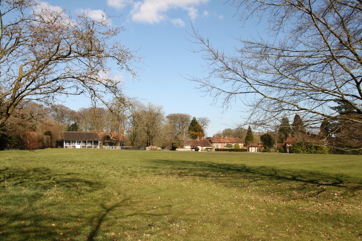
Greys Green – The Settlement at Greys Green was marked but not named on 18thC Maps. It developed around an area of Common Land, called Greys Common in 1635 & Greys Green in 1676, of which more than 20-acres survived in 1844. Lying roughly equidistant from Greys Court, the Parish Church & Shepherd’s Green, the Hamlet was an important Focal Point & by the 19thC was the Location of a School, Cricket Pitch, Post Office & Smithy & later of the Village Hall & War Memorial.

Greys Green in 2009, showing the Cricket Pavilion (built 1983) & former Smithy (closed 1981, now a Private House). The Green & Grass Verge on either side of the Road was declared Common Land in 1949 & acquired by the National Trust in 1978.
At the beginning of the 20thC the most prominent House was Copse Hill, occupied by a Henley Brewer, George Brakspear. Other large Houses were Built before WW2, especially on the Green‘s South-western edge along the Road to Bolt’s Cross. Later Development was also Limited to Individual Dwellings. In 1951 an Avenue of Cherry Trees was planted along the Road to commemorate the Festival of Britain & in 1984 the Settlement was designated a Conservation Area. The Focus of the present Hamlet is the Cricket Pitch, around which the Houses are loosely scattered, many hidden by high walls & thick hedges & divided by an increasingly busy Road.
Shepherd’s Green – The Settlement at Shepherd’s (formerly Sheepways or Shipways) Green similarly grew up around a small area of Common Land, much of which still survives. The surname Shipway was in use in the 16thC, the place was recorded in 1679 & the Settlement named on 18thC Maps. Several Houses date from the 17th or 18thC, including Backus on the Green’s North-eastern edge, which was probably the home of the Carpenter John Backhouse (d.1692).
Backus: (Formerly Listed as Land End Farmhouse) Cottage. 17thC Timber framed, rendered Infill, plain Tile Roof, centre Ridge Brick Stack. 2-unit Baffle Entry. 2-Storey, 2-window Range. 2-light Casements to Ground & 1st-Floor. Central plank Door. Roof half-Hipped to left. Right-hand return has re-set Gothic Casement window to Ground-Floor.
Interior: Queen-post Roof with Wind-braces visible in the 1st-Floor Room to right.
The Hamlet has a more nucleated appearance than Greys Green, with Houses lining either side of a Lane leading to the Common. Development in the 20thC, including a Row of 3-Council Houses, blended unobtrusively with the existing Housing Stock, preserving the Hamlet’s character. To the West a New Road – Satwell Close – was Built in the 1920s, to provide access to an Exclusive Estate of Large Houses. The Green Tree Public House Opened in the 1830s & Closed c.1960 when it was converted into a Private Residence. There was also, briefly, a 2nd Public House called the Harrow in the late-19thC.
Satwell – The Settlement at Satwell lies at the Junction of the Nettlebed–Reading Road (the B481) & the Road to Henley. The Hamlet was probably named after Sotwell (meaning Sutta’s Spring or Stream) in Berkshire: there is no such Stream at the Oxfordshire place, but John James (d.1396) Held Land in both Parishes. In 1844 the Hamlet comprised 2-Farmsteads & 6 other Houses; the 2-Farms may have been the successors of 2-Estates which included Land in Satwell in the Middle-Ages. The Settlement was marked on a Map of 1725 & named on Maps of the later-18thC.
The Parish Workhouse was Located at Satwell in the mid-18thC. A Pub called The Lamb (which survived in 2006) opened possibly in the early-19thC & certainly before 1860. In the early-20thC, a number of large Houses were Built at Satwell, including Satwell’s Barton & Satwell Spinneys. Subsequent Development was similarly limited to Individual Dwellings. Before 1960 the straightening of the Nettlebed–Reading Road enabled through-Traffic to bypass the Hamlet.
Highmoor Cross – The Settlement at Highmoor Cross grew up at the Junction of the Nettlebed-Reading Road & the Road to Witheridge Hill, of which Hamlet it may have formed part in the 18thC. Later Highmoor Cross had a distinct Identity. In 1844 its 8-Houses included Stonehouse Farm & a Beerhouse called the Cannon; that was later replaced by the Woodman (Closed in 1984) further down the Nettlebed-Reading Road. St Paul’s Church was Built on the Site of the Cannon in 1859, to serve the new Ecclesiastical Parish of Highmoor. A Well was Sunk in 1865, a Post Office was Opened & in 1920 a Village Hall was erected by Public Subscription as a War Memorial. Also in 1920, a Row of 12-Houses was Built by Henley Rural District Council. In subsequent decades the Settlement continued to expand. The Sale of Glebe Land in 1947 allowed Housing Development to the South-east of the Church, and other Private & Council Houses were Built at intervals throughout the 2nd-Half of the 20thC.
Highmoor – The Settlement at Highmoor developed along the edge of Highmoor Common, on the West side of the Nettlebed–Reading Road & was named on 18thC Maps. In 1844 the Settlement comprised about 17-Houses, including Highmoor Hall & Highmoor Farm, parts of both of which were Built in the 17thC. Of the 2-Public Houses, both of 18thC Origin, only the Dog & Duck survived in 2006 (now Closed). The Green Man Closed in the late-1890s or early-1900s & was converted to a Private House. There was some New Building in the 20thC, but Development was mostly limited to the improvement of existing Houses & conversion of Farm Buildings into Residences.
Witheridge Hill – The Settlement at Witheridge Hill grew up around an area of Common Land on the Western edge of Rotherfield Greys Parish. Presumably, there was Settlement in the area by the 1290s, when Ralph of Witheridge (de Wyterugge) was Fined at the Bensington Manor Court. The name is Anglo-Saxon, meaning ‘Willow Ridge‘ & was recorded on Maps of the 18thC. In 1844 the Hamlet comprised about 19-Houses.
A School existed by 1841 & a National School was Built overlooking the Common in 1862. There were 2 Public Houses: The (Old) Sun, later The Rising Sun, 1st recorded in 1804, which survived in 2006 & another which Closed in the 1850s. A Grocer’s Shop was Opened in the mid-19thC. A few New Houses were Built in the 20thC in the Southern part of the Hamlet, but Development was mostly limited to improvement & enlargement of Existing Buildings.

Rotherfield Grey’s Tithe Map 1844
The Built Character: The Buildings of Rotherfield Greys are similar in character & style to those of neighbouring Parishes, the consistent use of Timber-framing, Brick & Flint, with Clay Tile & Thatch, giving an eclectic mix a harmonious impression. From the 18thC almost all degrees of Building were constructed of Brick, made presumably at one of the nearby Kilns. Apart from Flint (which was often used as infill), Building Stone was unavailable Locally. Except for Greys Court & the Parish Church (both described below), surviving Buildings are all post-Medieval. Some of the Farmhouses may have been built on the Sites of Medieval predecessors, but the present Buildings date from the 16thC & later. The Rectory House, too, originated probably in the Middle-Ages, though the existing Building was extensively remodelled in the 18thC. A few Cottages survive from the 16th or 17thC, but most of the present Housing Stock dates from the 18thC & later.

Cowfields Farm, Rotherfield Greys (Pdf formerly Colvilles Farm)
An isolated typical Chiltern Farmstead, dating from c.1500 with a Timber-framed Farmhouse, probably starting as a small Hall House, with Timber-framed Wings added over the next 2-Centuries. Adjacent to the North & North/West are 2-Large Timber-framed Barns with other Service Buildings of various dates, mostly Brick-built, such as Stables, Cowsheds, a Bullpen & Shelter Sheds around the Farmyard.
Two notable examples of high-class Farmhouses built probably for prosperous Yeomen are Hernes (described below) & Lower Hernes. The Latter originated in the mid-16thC as a 2-Storeyed Timber-framed House of 2-Bays (later extended to 3). Tree-ring dating suggests a construction date of 1567 when the Owner (Sir Francis Knollys) was rebuilding Greys Court. In the 17thC the House was extended into an L-Plan by the addition of a large South Wing. The earlier part has a large panelled Frame with curved Braces & a Queen-post Roof & retains an original diamond-mullioned window & some chamfering to Internal Timbers. The 17thC Range is more sophisticated: the 1st-Floor has chamfered Beams & Joists & the South Face glazed windows with ovolo-moulded mullions. The infilling of the Frame (Brick in the South Wing & Brick-&-Flint in the North-west) may be original.
By contrast, the state of lower-class Rural Housing, especially in the West of the Parish, caused 19thC Clergy some concern. In 1799 the Rector of Rotherfield Greys thought that there were ‘too many old houses’, and in the 1860s the Vicar of Highmoor complained about ‘the bad Dwellings of the Poor’ & ‘the indecent crowding of the Poor in their Cottages’. Many of these were Farmworkers’ Estate Cottages, usually Brick-built & Thatched. Most were Sold-off in the early-20thC, and subjected to an ongoing process of enlargement & improvement.
There appears to have been little speculative Building in the 19thC, perhaps because of the Control exercised by great Landowners such as the Stapleton’s in the East & the Stonor’s in the West. Following the sale of their Estates in the early 20thC, piecemeal development got underway. Satwell Close, for example, to the West of Shepherd’s Green, was built up following the Sale of the Greys Court Estate in 1922. Other Fields Auctioned as Building Sites the same year seem not to have been built on, suggesting limited demand for Housing: a Local Schoolmaster made a similar observation in 1912 when he Purchased a Cottage which he Let for the very modest sum of £10 a year. But even though Property prices were Low, Cottages were often Let to London Professionals, foreshadowing later Gentrification. The impact of Henley & perhaps London was also evident at Satwell, where several medium-sized Country Retreats were built after 1918.
In 1920 Henley Rural District Council Built its 1st Council Houses in Rotherfield Greys, on Land given by the wealthy Landowner Sir Paul Makins of Henley. Despite opposition from some Councillors, the initiative was Championed by Harry Burr of Satwell, who was concerned that many Agricultural labourers lived in derelict Cottages. The 4-Houses were built to a high standard, costing far more than the estimate. Perhaps, as a result, 12-Council Houses built at Highmoor Cross later in 1920 were in a plainer style. More Council Houses were built later in the 20thC near the Church, at Shepherd’s Green, & at Highmoor Cross. Private Development occurred on a limited scale throughout the Parish, Cottages were enlarged & improved & Farm Buildings & Public Houses were converted to Residences. Only in the East of the Parish was the development on a much larger scale, Henley’s suburbs extending 1st over South Field & later over Farmland to the West.
Rotherfield Greys: Baptisms 1591 to 1848, Marriages 1592 to 1837, Burials 1592 to 1901
Reproduced from VCH Oxfordshire available at British History Online
