
The Parish is a small one of 869-acres and so far as is known its Boundaries have not changed since at least the 8thC: it is long & narrow in shape and lies between Watlington & Thame to the North of the Chilterns. It stretches from Haseley Brook on the North to Weston Brook on the South and is separated by these Streams from Great Haseley & Shirburn. Between the 2 lies Poppet’s Hill, probably deriving its name from the Old English words for ‘Goblin’s Pit‘ and reaching to a height of 347-ft. There is also a Low Ridge rising from 234-ft by Wheatfield Park to 433-ft at Gilton Hill or Gyldon as it was called in 1517 and continuing to above Clare where it reaches over 370-ft. There is comparatively little Woodland: in 1881 there were 33-acres which included Cornwall Copse in the North and part of Wheatfield Wood on the Eastern Boundary, and the acreage has been considerably reduced since. The Countryside, however, has by no means a bare appearance, for there were many fine Elm & Oak trees in the Hedgerows which give it a Park-like aspect. Eight of these fine Trees were planted by the Rector on the Glebe in 1840 on Queen Victoria’s Wedding Day, the marriage being Solemnised by his cousin, the Archbishop of Canterbury. From the Northern Slopes of the Ridge, on which the Hamlet of Stoke stands, the prospect commands Wheatfield Park to the North-east and the Vale of Haseley to the Northwest – a typical South-Oxfordshire Landscape.
Ordnance Survey Map 1830
Along the Ridge runs a Secondary Road that links the Main Roads from Stokenchurch & Watlington to Oxford. This Route must have been of some importance in the Middle-Ages as it was the chief Link between Thame & Wallingford & Wallingford was on the Water Route to London and until it was superseded in importance by Abingdon in the early-15thC was one of the main Stages on the London Road to the West. Wallingford Way is conspicuous in contemporary Documents, even a Stoke Footpath being described as the way to Wallingford. It was this Route which was probably the cause of bringing violence to Stoke on at least 2-occasions. In 1224 it was alleged by the Widow of Ralph Talemasch that during the Barons’ War her Property had been severely Damaged by Richard Foliot & Vivian Fitz Ralph over a Period of 3-weeks. They had carried off 26-Armed Servants, a Plough-team of Oxen & 2-young Oxen, everything in her House-chest & the Bedclothes. They had put Locks on her Barns and handed the Keys to Robert Druval so that she could not have the Keys and have her Chattels without paying 40s. In the 16thC 2-Yeomen of London & a Gloucester man were pardoned in 1528 for breaking into the Houses of a Widow at Stoke and Robbing her & her Servant, and for mortally wounding William Pangbourne. As one of the Londoners was said to be also of Doncaster & Painswick (Glos), both places in Wool-producing areas, he was probably a Woolman Journeying from London to the West Country.

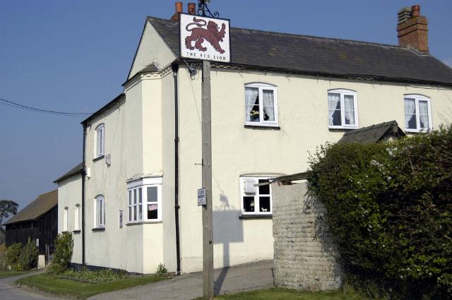
Stoke Talmage itself lies in the Centre of the Parish at a height of about 320-ft. It is 5-miles Southwest of the Market Town of Thame and 3½-miles North of Watlington. Never a large Village, it has now dwindled to a small Hamlet, and there is only 1-Farmhouse, Stoke Farm, left in it. In 1960, besides this House there were the Rectory, the ‘Red Lion‘ Public House, the 19thC School-House, & School of Chequer Brick (then used as a Private House), a few old Stone Cottages bordering the Churchyard, 4–Red-Brick Cottages Built by Lord Macclesfield in 1902 & 2-new Council Houses. In an account of about 1700 of the Manor Estate, besides Stoke Farm there were 3 other Houses described as Farms, together with the Place House belonging to Mr Tipson, 5-Dwellings with Orchards & Closes or other Land, a House & Blacksmith’s Shop & 3-Cottages, of which 2 were on the Waste. In addition to the Houses & Cottages listed the Rectory & Stoke Grange Farm, which Lay outside the Village, certainly existed then. In 1738 the Rector reported that there were 23-Houses in Stoke and this roughly corresponds with the details given on an Estate Map of 1750. The Map shows that the Village was clustered around the Church and Lay entirely off the Main Road & along the Branch Road to Stoke Talmage and a Parallel Lane ending in the Village, whereas later Houses have been Built along the Lewknor Road.
The 18thC ‘Red Lion‘ on the Lewknor Road, therefore, dates from the 2nd-Half of that Century. The 1750 Village consisted of Stoke or Manor Farm, the Rectory, and next to it Place House, the most important Building in the Village. Besides 14 small Dwellings & Cottages; the Map depicts 2-Farmhouses. Hedged Closes lie to the West of the Houses, a Vineyard at the North end of the Village, a Common of 18½-acres lies on the Wheatfield Boundary, and the Open-fields lie to the South with Stoke Grange Farm in an isolated position to the North-west of the Village and on the Eastern Boundary of the Parish.
OS Map 1919 South Oxon XLVII.2 (Adwell; Stoke Talmage; Wheatfield)
Stoke Farm is shown as an L-shaped House of 2-Storeys, with a Large Yard surrounded with Outbuildings, on the South Corner of the Village Street. John Taylor, the Constable & Farmer of the Manor Farm, was living in this House in 1665 and returned 5-Hearths for it, but this was probably before the rebuilding: a Lease of 1697 to Ralph Taylor speaks of it as having been ‘newly erected‘. In 1796 it had Stabling for 13-Horses and its Outbuildings were of Brick, weather-boarding and lath & plaster. Today the Brick Facade of the House conceals an earlier, possibly 16thC, Building of Chalk & Timber which has been enlarged at later dates.
The Place House no longer exists. It may have been Built in 1588, for Rawlinson noted that it had an Inscription on the Outside of the Gateway which ran: ‘Get all thi goods justli Spend them moderateli Relive them daili. Anno dni 1588 Optime mors veni Pessima vita vale‘. On the inside of the Gateway, facing the House, was another Inscription: ‘Serve God ever duli‘. This House was probably the one for which 7-Hearths were returned in 1665 by Thomas Quatremain, or it may have been the one with 5-Hearths owned by William Baker, ‘Gentleman by my owne view‘, who can be identified with William Barker of Sonning, the Patron. The 1750 Estate Map shows Stoke Place as the most imposing House in the Village: it is depicted with 2-Storeys & Attics and a central projecting Bay. It is mentioned in the Inclosure Award of 1811, but only Place House Close is shown on the Map. The House had presumably been recently pulled down.
Stoke Talmage Tithe Map 1842
The Rectory dates from 1752 and was Built by the Rector, William Wilson. It replaced a House of 6-Low Rooms with Chambers above and was Built some 40-yds away in the Orchard of the Old Rectory, then Ruinous. The new House was of 2-Storeys with Garrets above. There were originally 4-Rooms on each Floor, but by 1820 the House was considered too small and various Offices were added at a cost of £560. The Architect was Daniel Harris of Oxford. The House has an elegant Interior and there have been no recent alterations to the Exterior.
Stoke Grange Farm is on the Site of one of the 4-Oxfordshire Granges of the Cistercians of Thame Abbey, and there is still a Rght of Way leading across the Fields, formerly all Thame Abbey Land, from the Farm to Thame Park. The Land given for its Site in the 12thC was part of the Waste Land of Stoke Manor called the Marsh, and the Monks must have expended considerable Labour on Drainage. Today the Farmhouse standing above the Brook is a 19thC Building. Traces of the Medieval Moat surrounding the original Grange Survive, and in 1850 a Medieval Barn was still standing. Although all the Ancient Grange Buildings have since been destroyed by Fire a number of Inlaid Tiles once on the Floor of one of the Buildings have been preserved at the Farm. One of these Tiles bears a Crowned Head between 2-Hands raised – a Design common in the Neighbourhood. A few early hand-made Drains have also been found beside the Causeway built across the Marsh to Stoke Village.

At the extreme Southern End of the Parish lies Stokefield Farm. It, too, is in an isolated position, but this was a consequence of the Inclosure of the Open-fields in 1813 and the creation of separate Farms.
The Parish has been Associated with 2-Families of interest – those of Talemasch & Petty. The 1st was of Knightly Rank and gave Stoke its 2nd Name in the 12thC, and the 2nd is interesting as a local example of a Yeoman Family that rose into the Ranks of the Gentry in the 16th & 17thCs. Mary, the daughter of John Petty of the Stoke Branch of the Family who lived at Stoke Grange, rose even higher. She married James Ley, Earl of Marlborough (1550–1629). A son of John Petty, George Petty – or Pettie (1548–89), acquired Fame as a Romance Writer & Translator. As his cousin, Antiquary Anthony Wood said, he was ‘excellent for his passionate penning of amorous stories‘. His Translation of Guazzo’s Civile Conversation has a further Local Interest in that it was dedicated to Sir Henry Norris, who was later to become Lord of Rycote. Stoke Grange had passed out of the Pettys‘ hands by the time of Charles I.
Rather earlier in the 16thC 2-boys, William Gardner & his brother, were Lodging with a Tutor at Stoke, very probably with the Rector, Master Edward Chamber (fl.1505-26). A letter from William to his Parents in London has been preserved: he asks that he and his brother may be sent ‘Shoes against Easter for we have none except what we Wear every day‘, also a Cap each & points for their Hose, the last being ‘Naught and Rotten‘. One other Local Item may be recorded here since the Scientist Lord Macclesfield advised the Parson to make a note of it in the Parish Register. It concerned the remarkable Weather of the years 1777–79, particularly the January of 1779 when the Season was so mild that the Blackthorn was in full Flower before the end of March and the Whitethorn in full Leaf: ‘that has not been experienced in the past 60-yrs.’
Manor Estate: In 1086 Stoke (Stoches), rated at 10-Hides, was Held by Roger d’Ivry, the Sworn Brother in Arms of Robert d’Oilly. In the early-12thC the D’Ivry Barony passed to John de St John of Stanton St John & Reynold of St Valery, either jointly or in succession. Reynold de St Valery was Overlord when Henry II confirmed a Grant of Stoke Land in 1165 and Bernard & Thomas de St Valery later Granted Charters of Confirmation. From the Valery’s the Barony passed in 1219 to the Counts of Dreux; it was Forfeited to Henry III and Granted by him in 1227 with all the English Lands of Robert de Dreux to Richard of Cornwall. Thus, the St Valery Lands, although they kept their separate Identity, henceforward formed a part of the Honour of Wallingford. Stoke was Held for 2-Fees, and paid a Rent of 60s to the Honour. In 1282 Earl Edmund gave this Rent to Rewley Abbey, and the Abbey later remitted half of it to Thame. In 1302 Margaret, the Earl’s Widow brought an Action for her Widow’s 3rd against Thame with regard to this Rent. According to a Confirmation by Edward II Rewley remitted 1st 30s and then the remaining 30s which were owing for the Lordship of the Vill, and also Suit of Court & Hundred, which the Earl had Granted it, both from the Abbot of Thame and other Free Tenants, along with View of Frankpledge. The King further confirmed that no Bailiff of the Earl might take distraint or intermeddle in Stoke in any way. Thus it was that in 1535 no Payments were being made to Ewelme Honour.
The Tenant in Stoke in 1086 was a certain Hugh from whom the Talemasch Family probably Sescended. The 1st of the Name to be recorded in Oxon is Hugh Talemasch, perhaps a son of the Domesday Hugh, who occurs c.1130–1150. He was evidently in the Entourage of John de St John: he was Fined in 1130-31 for Liberating a sum of Money to him without the Royal Precept and is Found as a Witness to the Charters of his Overlord, John de St John. It was from him presumably that the Village took its 2nd Name. He was the father of at least 3-sons, Peter his Heir, Robert & William, all of whom are found Witnessing Charters with him. He was also the Lord of Hampnett (Glos) which he gave to the Benedictine Abbey of Gloucester when he became a Monk there in his old age. His Heir Peter (I) married Maud, the daughter of Aucher Chevaushesul of Tetsworth, and so succeeded to Knight’s Fees in Tetsworth & Epwell, Held of the Bishop of Lincoln. He continued the Pious Tradition of the Family and gave before 1155, with the consent of his wife, mother, brothers & sisters, over 2-Hides at Stoke in Free Alms to Thame Abbey; he also gave 10-acres to the Parson of Stoke, and one of his sons became a Lay Brother of Thame. Peter was dead by 1181 and a son Richard was in Possession. This Richard was one of 4-Knights appointed by the County in 1199 to choose 12 to make a Great Assize in a dispute over Land in Stoke; he married Avice, the daughter of Richard Taillard, one of his Adherents, and they had a daughter and at least 4-sons, of whom one Ralph became a Monk of Thame. Peter (II) Talemasch had succeeded his father by 1205, and a Suit of 1207 reveals that he Held 4-Knight’s Fees in Stoke & Chilworth. In 1208-12 he was returned as one of the Knights of the Honour of St Valery presumably for his Stoke Fees, but he was Granting away more of his Demesne Land in Stoke about this time and may have alienated most of his Rights there soon after. The Talemasch Grange at Stoke seems to have been disused by 1220 and replaced by the Monastic Grange. Other Oxon Land was certainly being alienated: a ½-Fee in Finstock was Granted to Eynsham in 1205; Fawler Land was Granted in 1220–22, and before 1223 the Chilworth & Coombe Estate was Sold. Peter was followed by 1241 by his Heir William, who figures in various Suits over Stoke Land in 1261, but the Family’s remaining Rights were soon Transferred. In the Survey of 1279, there is no reference to any Talemasch Overlordship over Thame’s Holding which had increased since about 1240 to 4½-Hides. In 1296/7 the Earl was said to receive 40s from the Abbey for Land formerly Held by William Talemasch and 20s from that formerly Held by Sewaly of Stoke, a Tenant of whom nothing is known. In 1316 the Abbot alone was returned as Holding Stoke Talmage; the place was included among the Abbey’s Demesne Lands in a Grant of Free Warren in 1365 and Thame retained Possession until the Dissolution in 1539.
In 1542 Stoke Talmage was Granted with Tetsworth and other Manors to the Bishop of Oxford, Robert King, who had been the Last Abbot of Thame, but in 1547 the new Bishopric Ceded it with 5 other Manors to the Crown. In 1553 Edward VI Sold the Manor, Advowson, Stoke Grange, and other Land as 1/40th Knight’s Fee to John Petty (Pettie), Gentleman (d.1578), for a cash payment of £564. John Petty had Held the Manor from Bishop King (then Abbot of Thame) in 1538. The Pettys were a widespread Oxon Family of lesser Gentry and had long Held Land in Tetsworth. John Petty of Stoke Talmage, the son of John Petty of Tetsworth, received a similar Royal Grant in 1611/12. He and his wife and other Members of the Petty Family conveyed the Manor to John Symeon, Esq, & Edmund Symeon, Gentleman, in 1612 and in 1612 & 1614 the 2-Symeons are described as Lords of the Manor. The Grant, however, evidently did not include all the Petty Property in Stoke for John Petty still Held Stoke Grange & Stoke Farm at his death in 1621.
The Symeon Family were Lessees of Pyrton, where they lived. Edmund Symeon died in 1622 and his brother Sir George of Brightwell Baldwin became Heir to the Manor & Advowson of Stoke. He received these in 1623 and immediately Sold them to Katherine Litcott, Widow, & William Barker, Gentleman. In Court Rolls of 1628 ‘Lady Litcot & Mr Barker’ Occur as Lords, but the Litcott interest ended with Lady Litcott’s death. The Barkers were a Sonning Family. William Barker (d.1676) married twice; his 2-daughters by his 1st marriage, Frances & Ann, married respectively Richard Howse of Whitley (Berks) & Sir Pope Danvers; his son William by his 2nd marriage succeeded to Stoke and died without Heirs in 1694. The Legatees of William Barker Jr, were Mary Howse, daughter of Frances Woodward (formerly Howse) and wife of Sir William Kenrick, & Ann, the wife of Sir Pope Danvers. Stoke Manor, in consequence, was divided at one time in 1/6ths and at another in Quarters among their Descendants. Sir William Kenrick’s Will, Proved in 1699, left a Life interest in his part of the Property to his wife, which was thereafter to be divided between his 3-daughters, Frances, Mary & Grace. By his wife’s Will, Proved 1705, the division was to be equal. An agreement of 1708 about the Share of Sir William’s eldest daughter Frances Child related to 1/6th of the Manor, and another agreement of 1716 made between Daniel Danvers, son of Sir Pope Danvers & Grace Kenrick, Spinster, related to 1-Quarter. In 1720 Grace, by then married to William Wykes of Hazlebeech (Northants.), and her husband Sold their Quarter of the Manor of Stoke & Sonning to Thomas, Lord Parker, Baron of Macclesfield. The 2nd Quarter of the Manor was Purchased in 1769 from the Guardians of Elizabeth Hill, a granddaughter of the eldest daughter of Frances Child, and from John Gutteridge, whose wife, the youngest daughter of Frances Child, had a 1/24th part. The Danvers half of the Manors had descended to Daniel Rich, who Mortgaged his Estate to Robert Palmer, who ultimately acquired them. In 1772 Palmer exchanged his half of Stoke, paying also £6,000, for the Half of Sonning owned by Lord Macclesfield. Thus the whole Stoke Estate was united in the hands of Lord Macclesfield of Shirburn Castle with whose Descendants (Parker) it still remained in 2003.
Lesser Estates: Beside the Main Estate, there were a number of lesser Freeholdings in 13thC Stoke. The Chief of these seems to have been the ½-Fee Held of the Talemasches by the De Turs or De Turri Family. The curia of Richard de Turs in Stoke is mentioned in the 1st Decade of the Century and so is his Land in the Open-fields; he was a man of Local importance and is often found as a Witness of the Charters of Peter Talemasch, about the 2nd Decade of the 13thC. He was probably of the same Family as, if not identical with, Richard de Turri, who Held a Bledlow Fee in Bucks, and with the Richard le Thurs who was Sheriff of Oxon in 1202 to 1206. In 1222 this ½-Fee, then Held by Peter (II) Talemasch, was the subject of a dispute between Roger de la Hyde, the husband of Avice, a daughter of Richard & Agnes de Turs. Roger was claiming the Fee against the Widowed Agnes because of her pregnancy; it was decided that if her child proved to be a boy he should surrender the whole Property if a girl the Moiety of it.
In a Suit in 1261, when Agnes de Turs was ‘Lady of the Fee‘, a Thomas Talemasch, Son & Heir of a Ralph Talemasch, who must have been some relation of William Talemasch, the Head of the Family, seems to have been Overlord of the De Turs Fee. Ralph Talemasch had, it seems, recently bought all or part of it (8½-Virgates) from Richard de Turs (le Thous). There is no record, however, of this Talemasch Holding in the Hundred Rolls and the only member of the Talemasch Family recorded there was Holding a Virgate in Clare of Margery de Bruys. It is probable that Right of Overlordship had been granted to Thame Abbey with the other Talemasch Land: a Richard de Turs Quit-claimed to the Abbot of Thame for 100s in a Fine over a ½-Virgate in 1247 and in 1279 7-Virgates were said to be Held of Richard de Turre ‘de Heye‘, for 5-Marks and 11s and for Suit to the Abbot. It was probably before 1211 that Peter Talemasch gave a ½-Hide of his Demesne and 4-acres of Meadow to the Templars with his Body for Burial. In 1210 the Master of the Temple, Amaury, Lost an Assize of Novel Disseism (recent dispossession) against Peter’s mother Avice about a Virgate of Land in Tetsworth, as Peter failed to Warrant his Charter Granting the Land to the Templars. Peter, therefore, gave the Master 3-acres in Stoke in exchange, during the lifetime of Avice. On her death, the Virgate in Tetsworth was to revert to the Templars and the 31-acres to Peter Talemasch or his Heirs. At about the same time Peter gave another 5-acres in Stoke & Maud the daughter of Ralph of Shirburn gave c.1225 ‘all the Land‘ in Stoke which Peter Talemasch had given her father; and this was confirmed by Robert de Burghfield, who may have been Ralph of Shirburn’s Successor or Mesne Lord. There is no Record of the Estate in 1279, but the Hundredal Survey for Stoke is defective.
This Templar Property evidently passed to the Hospitallers in the 14thC, although there is no specific mention of Stoke Talmage in a Survey of their Estates, dated 1338. It is likely, however, that the Land was included in their Warpsgrove & Easington Property, which was Held at Farm by Sir John Stonor. In 1512 Stoke, worth 13s-4d was held at Farm with Easington & Chalgrove. In 1542 part or all of the Stoke Property, described as Temple Lake, passed by Royal Grant to Richard Andrews & Leonard Chamberlain of Woodstock. There are frequent references to Temple Lake in the Chamberlain Deeds and it is marked on an 18thC Estate Map as a large piece of Inclosed Pasture.
Agrarian & Social History: As Stoke was Rated at 10-Hides in 1086 and was thus one of the many 5-Hide Units in the Country, the Boundaries of the Township may be taken to be at least as Ancient as the 8thC, when this System of Hidation was probably imposed. The Geology of the area certainly favoured early-Settlement: there is a mixture of Soils, well adapted to mixed Farming & 2-Brooks. Near Haseley & Weston Brooks the Soil is Heavy Clay, but on the Ridge, it is composed of Flint & Chalk with a sub-soil of Clay. At the time of the Domesday Survey, the Estate appears to have been fully Cultivated. There was Land for 6½-Ploughs: nearly half was Demesne with 3-Plough-Teams & 3-Serfs at work, while 10-Villani & 9-Bordars shared another 3½-Plough-Teams. The Record makes a comparatively rare reference to Meadow (97-acres) & Pasture (13-Furlongs × 1-Furlong 12-Perch). There had been a considerable rise in value from £7 to £10 since the Conquest.
12thC evidence reveals Radical changes. In a Charter of c.1150 the Land of the ‘Francolensii‘ is mentioned & later evidence shows that apart from the Principal Estate in Stoke Held by the Knightly Family of Talemasch there were a number of Freeholds belonging to their Adherents, among them the Le Grant, Sandwych, De Stoke & De Turs Families. An important development occurred in the Middle of the Century when Peter Talemasch Granted 2-Hides, 8-acres of his Land to the Cistercians of Thame Abbey and Land in the Marsh (in merse) by the Spring for Building their Grange. References to the Furlong next to Cripsehulla (i.e. Cripshill in Clare), to Peter’s Demesne lying between this Furlong and the water (i.e. Haseley Brook), to the Marsh, and to Wallingford Way and the Lane from Wheatfield make it clear that most, if not all, of the Land Granted lay at the Northern end of the Parish. Although the Land lay in 11 or 12-Furlongs in the Open-fields, much was already consolidated. For instance, the whole cultura of 25-acres and the whole of Mers Furlong (except 35½-acres), la Breche, and most of another Furlong were among those given. The Demesne Meadow Granted was clearly Inclosed and another piece of Meadow belonging to 1½-Hide of Arable Land was said to Lie together. It is likely that an Inclosed Estate was contemplated from the beginning. This low-lying and badly drained part of the Parish described as Late as 1842 as ‘indifferent pasture‘, was eminently suitable Land for improving Farmers such as the Cistercians. A Grange was Built, and the Property was added to by other Grants of Land from Free Tenants. The Location of the new pieces of Land, all in the same Furlongs as the Land of the original Grant, or close to the Grange, or to the Wheatfield Boundary, point to the consolidation of the Estate. About 1195 a further step in this direction was taken when Lawrence de Stoke made an exchange of Land with the Monks.

Early in the 13thC, the Talemasch Family added more than another Virgate to their original Grant, and this Land, too, was in the North of the Parish, some on the Clare Boundary. By the mid-13thC, the Abbey Held 4½-Hides out of the 10-Hides in the Parish. As the Virgate was about 22-Field acres, they Held about 396 Field acres. The rest of Stoke’s Land, however, was still in the hands of small Freeholders, and apart from the De Turs Fee, no sizeable Property seems to have been Built up. In a List of Tenants, drawn up about 1240, this Fee comprised 7½-Virgates. The next largest Holding belonged to the Templars, who had acquired 3½-Virgates of their 1-Hide Holding from Peter Talemasch; 4-Tenants held a ½-Hide each, and 5-Others, including the Parson, Held about a ½-Virgate or a Virgate. One of these Tenants was indebted in the sum of 36s-8d to Abraham the Jew.
Although much of the Account of the Parish in the Hundred Rolls is Defective there is no doubt that in 1279, apart from the Abbey’s Manor, small Freeholds were the chief characteristic of the Tenurial pattern. There were now some 31 different Holdings, though not all were Held by different persons. The Abbey itself had superseded the Talemasch Family as Lords of the Manor and had 16-Tenants, who were clearly Freemen: they paid Rents of varying amounts, though 8s a Virgate recurs several times, did Suit at the Abbot’s Court and usually at the Hundred of Pyrton as well. Most of them owed Scutage and none owed Labour Services. A few Free Tenants held of other Lords: 2 owed Suit to the Court of Lawrence de Sandwich, 2-Held of Robert de Stoke, and both of these men seem to have held directly of the Honour. So also did Richard de la Hyde, the Lord of the neighbouring Manor of Adwell & of many others. In fact, the last 15-entries relating to Stoke apparently concern his Property and it seems that the only 2-Tenants recorded as owing Boon-works were his.
The Account in the Hundred Rolls is supplemented by a contemporary Record in the Thame Cartulary, which states that the 8½-Virgates once belonging to Richard le Turs had been bought by Ralph Talemasch and were divided into 4 x ½-Virgate Holdings, 4-Virgate Holdings & one of 2½-Virgates.
As so many of the names of Tenants are missing in the 1279 Survey it is impossible to calculate their number, but it can be said with certainty that many of those named, like Richard de la Hyde, did not Live in the Parish. It may be hazarded that the growth of the Population in the 12th & 13thCs, which was a familiar phenomenon in other neighbouring Villages, was checked at Stoke by the arrival of the Cistercians. Only 11-Persons were assessed for the Tax of 1316 & 9 in 1327, and only 38-Adults were listed for the Poll Tax of 1377. The small size of the Population may be attributed to the Cistercian interest in Sheep-Farming, for which the Stoke Meadows & rough Pasture were well suited. The small number of Tenants Taxed in the early-14thC may be a consequence of the System, which was almost certainly in use, of employing resident famuli at the Grange, who would escape Taxation. When the Parish’s Tax assessment was revised in 1344, it was fixed at the relatively low sum, considering its acreage, of £1-19s-10d and this, too, one must suppose was owing to the influence of the Abbey which was able to bring pressure on the Tax Assessors.
Almost no evidence has survived about the Administration of the Grange. An indication of the type of Farming adopted by the Cistercians and a sign that there had been complaints by other Tenants may perhaps be detected in a Confirmatory Charter of Peter Talemasch’s Overlord, made some time between 1166 & 1190, where it is laid down that the Monks must not Overstock the Land. On the other hand, a Talemasch Charter of c.1210 suggests that they may have practised mixed Farming: they were to cultivate or use how they would a Grant of Pasture Land. The Income derived from the Farm in 1291 was £16-6s-3d, of which £14-10s-3d came from Lands, Reliefs, & the Dovecote, 6s from the Herd of Cattle, and the rest from Rents. In 1477–8, when the Abbey was Leasing the Demesne for £10, it received £10-12s-11d from Rents of Assize & Customary Tenants, and in 1535, in addition to the £10 for the Farm of the Demesne, it was getting £15-15s-5d from Tenants. The post-Reformation History of the Grange, which alone of the Stoke Farms was Inclosed & Tithed separately, in conjunction with the evidence of Medieval Charters, makes it likely that the Abbey here, as in its other nearby Properties, had succeeded in Building up a compact Estate. One of its Tenants, moreover, was accused in 1517 of Inclosing 40-acres of Arable and of allowing the Farmhouse to fall into disrepair. It appears also that the Templars, or possibly the Hospitallers, had Consolidated their Holding in Stoke. Temple Lake Close & Temple Mead are mentioned in a Terrier of 1685 and can be Located on the Map of 1750, Temple Mead then being called Mr Toovey’s Mead.
In the rest of the Parish, Open-field Farming was practised in the Medieval Period and after – 3-Fields are recorded by 1211: they were the North, South & West (or Chelfield) Fields. When Peter Talemasch Granted a ½-Hide to the Templars the Land was equally divided between these 3-Fields, though unequally as regards Furlongs. In the North Field they were distributed in 3-Furlongs, in the South Field in 5-Furlongs, and in the West among 14-Furlongs, many of them in ½-acre Strips. Fieldnames indicate that, besides the Staple Crops, flax, beans & pease were grown. There is also mention in c.1211 of a Reed Bed of 4½-acres, measured by the Perch of 15½ft. Some Furlongs were laid down to Grass: a cultura of Pasture in the early-13thC contained 15½-acres. Holdings, in general, were probably in small Parcels, at least in the early-Medieval Period – 10-acres of the Rector’s Glebe, for example, was divided into 9-Parcels.
Evidence for Agrarian changes in the 16thC is lacking except for what can be deduced from the Tax Assessments and a Survey of 1551. The List of Contributors to the Subsidy of 1524 is not as informative as in most cases, for Stoke Talmage & Wheatfield were Taxed together. There were 14-Contributors in all. In 1577 there were 6-Contributors at Stoke compared with one at Wheatfield: all 6 of the Stoke Farmers were Taxed on £4 or £3 worth of Goods – a Common Sum for the small Yeoman Farmer. The fact that there is no outstanding Contributor suggests that the Manor Estate, like the Grange, was at this time Held by more than one Tenant and was Divided into several small Farms. The Family names of the Taxpayers in 1577 recur on Lists of Tenants drawn up in 1607 for supplying Wheat to the King and for making the Common Payments to the Hundred of Pyrton. In the latter case, there were 8-names, including that of the Parson and the Lord of the Manor. All were rated on 1 or 2-Yardlands with the exception of Richard Chapman, perhaps the Tenant of Stoke Manor, who was rated on 5-Yardlands out of a Total of 16. In payments of Wheat, however, Ralph Quatremain contributed 7-Quarters & Mr Petty 3 to Chapman’s 2.
It is not until the 2nd half of the 17thC that evidence becomes rather more plentiful. It is not known whether the Grange was by this time Farmed as a Unit or whether it was still Divided, but Manor farm or Stoke Farm had certainly become a Large Farm. It consisted of 214½-acres in the Open-fields. The Rent in 1628 was £80, in 1647 & 1669 £92 & 6-bushels of Wheat, and in 1693 it was raised to £102 & 6-bushels of Wheat after a new Malthouse had been Built. John Taylor, the Tenant, was clearly the Leading Farmer in Stoke. The Manor Farmhouse was used for the Courts, Held twice a year by the Lord’s Steward & Taylor was bound by his Lease to provide Dinner for him and his Company up to the number of 6. The Tenant of Stoke Grange Farmhouse at this date is not known for certain, but it is likely that he was John Fletcher, who returned 3-Hearths for the Hearth Tax of 1665. The building as it appears on an Estate Map some 100-yrs later was certainly a comparatively modest one.
Court Rolls of the Period show that Copies were usually for 3-Lives and that Heriots were exacted & occasional Works. In 1671, for example, the son of a deceased Tenant was admitted to 55-acres of Land for a fine of £2, the best Beast as Heriot, and an obligation to Plant 4-Oaks, Elms, or Ash. He was also bound at the request of the Lord to work yearly 2-days with his Plough in Ploughing & Sowing, to Plough yearly by the direction of the Lord the Land of 1-Cottager, taking not more than 12d for each acre, and to carry 1-Load of Wood for the Lord for a distance not exceeding 8-miles. Another Tenant had to find a Labourer & 1-Woman to Reap at Harvest time. Another, occupying a House that returned 1-Hearth for the Hearth Tax, had to find 1-Man to work 2-days in Autumn or Forfeit 2s; at a Court Baron of 1686 the Homage Presented that the Executors of a Copyholder ought to have an ‘Executor’s Year‘, viz. if the Tenant died before Lady Day (25th March) they were to enjoy the Land until the following Michaelmas (29th September); if after, they were to enjoy it for a whole year from the Michaelmas following. The next Tenant might enter on the Fallow Arable and on the Meadow & Pasture at Lady Day. It was also stated that Customary Tenants ought to have the Timber growing on their Tenements for necessary repairs.
A Note about the Manor Land explained that the Greensward lying among the Farm’s Arable was what is left Unploughed. It lay chiefly in Westcut Field, at Park Corner & Temple Lake (Field).
Inventories attached to Wills show as one might expect in a Parish with much good Soil and within easy access of both London & Oxford that the emphasis, at least on the Larger Farms, was on Cattle and Wheat-growing rather than on Sheep Rearing. On Stoke Farm in 1633, there were 13-sheep & lambs, worth £4, compared with £40 worth of Cattle & £36 of Horses. This emphasis was more pronounced at the end of the Century. When the Tenant, John Taylor Jr, died in 1696 his Chattels, together with those of his son, were worth £546: they included 10 Horses & Colts, 28-Cattle, some Hogs & Pigs, but no Sheep. Their Crops, consisting mainly of Wheat & Barley, were worth £270, and their Malt & Malt-mill £40. The total acreage sown with Corn amounted to 141-acres. Other late-17thC Wills make no mention of Sheep, though most small Farmers probably kept some. Commons for Sheep as well as Cows were still allotted in the proportion of rather more than 1-Sheep Common for every acre in the Common Fields. The Total in about 1720 was 475-Sheep Commons as compared with 67-Cow Commons, valued at 6s-8d or 7s each. A few large Farmers, moreover, such as Robert May, who died in 1695 and was described as a Grazier, also kept sheep. May had a Flock of 122-Sheep, 11-Milking Cows & 7-Horses, valued at £208 as against Crops worth £121. Another, John Gibbs (d.1713), kept 102-Sheep & Lambs in the Common Fields of Benson and had Crops worth over £139, nearly twice the value of his Stock. Daniel Tipson (d.1699) had a Flock of 75-Sheep and other animals worth £134-10s as against Crops (wheat, beans, pease, barley, hay) worth £337-15s.
The Chief Crop grown was Wheat, but barley, pease & beans were also commonly sown. Oats appear to have been less popular in the 1st-Half of the Century, but they figure more commonly in later Inventories. A Yeoman who died in 1626, for example, had 20-acres of Wheat, 12 of Barley and 12 of Pease & Beans, and the prosperous Tenant of Stoke Farm, Thomas Quartermain, with Chattels worth £322 had the same Crops in 1633. To take another example from the end of the Century, Joseph Tucker had his Crops evenly distributed in 1696 between wheat, barley & beans. The Clause in a Lease of Stoke Farm in 1697 that the Tenant was to pay £10 for every acre of Grass Ploughed up indicates that War and the high price of Corn had made Arable Farming profitable and that it was necessary to safeguard the comparatively scarce Grassland.
Various changes took place in the 18thC. Copy-holding, for instance, gave way to Renting & Leasing. In about 1720 of the 16-Tenants of the Manor 5-Held by Copy for 1, 2, or 3 Lives and the rest Rented or Leased their Land for 1, 2, or 3 Lives, but there were 2-major changes: Farms became Larger and Open-field Farming was abandoned.
An Estate Map of 1750 shows that the Southern part of the Parish was still largely given over to the Open-fields. There were 3-Fields as there had been in the 13thC, but Inclosure had considerably altered their arrangement. Now called Westcut (155-a), Middle (87-a), and Temple Lake Fields (136-a), they lay, for the most part, South of the Village. There were 2-Large Inclosures in the South: Temple Lake Close (15½-a) in the middle of the Open fields and ‘M Toovey’s Mead (9-a) on the Southern Boundary, which was Lammas Ground. Westcut was divided into 2, the main part (117½-a) lying along the Weston Boundary in the Southeast of the Parish, the smaller part (37½-a) lying along the Clare Boundary, North-west of the Village. With the exception of this detached piece of Westcut Field and 2-Large Commons, Cow Leyes (36-a) and the Marsh (18½-a), everything North of the Village was Inclosed and mostly formed a part of the ‘Liberty‘ of Stoke Grange. Ten hedged Arable Closes, varying in size from 1¼-acre to 9¼-acres, lying next to Cow Leyes were the only Inclosed Fields not belonging to the Grange.
Ordnance Survey Map 1881-86
Since the Total Area of the Manor Estate, including the Waste, was 627½-acres, the Inclosed Land in the Parish belonging to the Grange must have amounted to over 200-acres. Some of it Lay to the South of Grange Farmhouse between the Marsh on the East and the detached part of Westcut Field on the West, but most of it lay to the North-east along the Wheatfield Boundary and across the Northern end of the Parish between the Boundary of the Manor Estate & the Haseley Brook. This Boundary can, in fact, be clearly seen on the Ordnance Survey Map of 1883, where it is indicated by a double Track running North from the Grange and then North-west just North of Cornwell Gorse. At the end of the 18thC, the Farm consisted of 220-acres, of which 18 were in Wheatfield, and was divided into Fields mostly of between 10 & 25-acres, but the 2-Largest were of about 45-acres.
Map of Oxford County 1797
Surveyed by a Local man, Richard Davis of Lewknor and Published in 1797. This large Map consists of 16-sheets at an impressively detailed scale of 1:31,680 or 2-ins to 1-mile. No more than 200 Copies were ever made, the evidence is based on all Sets of the Map having Manuscript Serial No.s – this Image is part of No.34. Very few complete Copies survive. In terms of what the Map shows, a clear break has been made from the Christopher Saxton-led Traditional County Map, as here far more detail than previously is featured. Not only are County & Hundred Boundaries, Rivers & Streams, Towns & Villages, Parks & Woodland depicted, but here we have Roads, Tracks, Hedges, indeed every Field can be seen, and relief is beautifully represented by the use of Hachures. Davis was also Topographer to His Majesty, George III.

By the end of the 18thC the small Farmer had been eliminated and the Open-fields were mainly divided between the Tenant of Stoke Farm and 2-Other Tenant Farmers of the Earl of Macclesfield, while the Inclosed North of the Parish was Farmed by the Tenant of Stoke Grange. In 1778 the Incumbent, in making a return of the Houses in the Parish, stated that there were 4-Farmhouses and about 16-Cottages. Stoke Farm had increased in size to 350-acres by 1796 and its Land was to a great extent consolidated. The whole of Westcut & Middle Fields belonged to it and more than half, if not all, the Common Pasture had been divided up among the Farmers into separate Holdings. The creation of Stoke Fields Farm (210-a) sometime before 1811 carried the process of Amalgamation a stage further. A Map of 1811 shows the new Farmhouse near the Southern Boundary and the whole of the Former Open-fields Inclosed. Since then the Parish has never had more than 3-Farms, this one, Stoke Manor & Stoke Grange Farms. Crops grown at this Period were wheat, oats, barley, pease & beans.
Parliamentary Inclosure in 1813 was mainly a confirmation of existing arrangements. The Award covered about 500-acres: the Rector received 15-acres, Lord Charles Spencer of Wheatfield 1-acre, and the rest, except for Roads & Footpaths, went to Lord Macclesfield. The effect of Inclosure on Population in these circumstances can hardly have been very great. The Amalgamation of Farms during the 18thC is likely to have resulted in some Decline – 52-Adults were recorded in 1696 for the Compton Census. Incumbents Recorded 23-Houses in 1738 & 18 in 1774, but the general increase in the County in Population at the end of the Century and in the early-19thC was also witnessed at Stoke. About 115-persons were recorded in 1768 & 153 in 1801. The peak of 140 was recorded in 1821, but this figure fell to 127 in 1831 as Paupers had been removed to the Workhouse at Thame. The Decline continued and in 1951 the population numbered 69.
Stoke Talmage Parish Tithe Map 1843
The effect of Inclosure on the use of the Land was probably also slight, though it doubtless contributed along with other Factors to the decrease in Arable Land in the 19thC. Arthur Young Agriculturist mentioned ‘much good grass‘ in the Plain early in the Century and ‘good Loam‘ Arable on the high Land. In 1842 Lewis’s Topographical Dictionary gave 252-acres of Arable as against 580 of Pasture. This trend had been reversed by 1914 when, before the outbreak of WW1, 2/3rds of the Parish was Laid down to Arable & 1/3rd to Grass.
Schools: There is no record of any Elementary School in Stoke until the 2nd-Half of the 18thC, but children were being at least Catechised in the 17thC, for in 1633 there were Citations for failure to bring Servants & Children to Catechism. A 100-yrs later, in 1738, catechising was said to be ‘pretty regular‘, and in 1771 children were being Catechised during the greater part of the year. There was no School in 1738 and although the Incumbent himself offered to pay for an Instructor, no one sufficiently qualified could be found.
A Voluntary Charity School for Teaching Children to Read was Recorded in 1768, but it no longer existed in 1771. The Minister in 1774 gave the absence of a School as 1-reason why no children were able to say their Catechism and why he had not yet expounded it. No improvement had been made by 1778 and, although in 1781 there was said to be hopes of Improvement by next Lent, in 1787 there was still no Voluntary Charity School. The Rector, who then Resided in the Village, again complained of the Ignorance of the Poor Children and in 1790 said that they were too Ignorant to be Catechised.
This situation continued for many years. In 1818 the Rector once more reported that there was no Endowment for Education and no Sunday School; that the Poor would ‘readily embrace the means of Education‘; and that Schools of Industry for Girls would be highly beneficial.

The 1st mention of a School in Stoke Talmage in the 19thC was in 1833 when there was an Infant School with 10 to 20-children for whom the Parents Paid, and a Sunday School with 6-boys & 12-girls supported by Subscription. The Vicar reported in 1834 that Infants of both sexes attended the Dame’s School (run by Working-Class Women) for as long as their Parents could maintain them at 3d or 4d a week and that 10-boys & 16-girls attended the Sunday School until their Confirmation. By 1854 only the Sunday School survived, but Lord Macclesfield promised to Build a School. This was done in 1858 at his Private Cost and in 1871 it had an Attendance of 46-children. No School Board was formed and the School continued for some time through the support of Lady Macclesfield, with an average attendance of 30 to 34-children; 28-children were attending the School in 1938 & in 1946 it was reorganised as a Junior School, the Seniors going to Thame Secondary School. Stoke Talmage School was finally closed in 1954, the children being transferred to Tetsworth School.
Charities: – Thomas Harroppe, by Will dated 1521, left an Annual Rent charge of 2s issuing out of ‘Church Lands‘, otherwise ‘concealed Lands‘, owned by him in Great Haseley for Distribution among the Poor of Stoke Talmage at the Discretion of the Curate. The Rent had remained unpaid during the 40-yrs before 1625, by which time the Land out of which it issued belonged to William Beale. By a Charity Decree of 1625, Beale was directed to Settle the Rent in Trust upon 10-Householders of the Parish. These Trustees were thereafter to pay it each Christmas to such Poor persons of the Parish as they with the Incumbent & Parish Officers might choose. The Trustees were also directed either to Pay into the Trust £3, being 30-yrs‘ accumulated Arrears, or else to Double the Rent. Presumably, in either case, they were to recover the cost from Beale. It seems as though they chose the 2nd course. At any rate, in 1738, a Rent of 4s, charged upon an Estate at Crawford, was being paid to the Poor. It continued to be paid until 1754 when Robert Hall, the Owner or Occupier of the Crawford Estate, withheld it.
Before 1738 an unknown Donor had left £2 yielding interest at 2s. This continued to be paid to the Poor until 1768, but cannot afterwards be traced.
