
Dorchester-on-Thames (Dorocina)
The modern Village, situated West of the River Thame about ½−mile above its Confluence with the Thames, occupies roughly the same position as the Roman Settlement. In late Saxon & early-Norman times the Town of Dorchester, having become a Bishop’s See, extended over a much larger though somewhat undefinable area; but as soon as the See was removed in 1085 to Lincoln, the Town began to dwindle, so that by Historian John Leland’s time (1542) it was nothing more than the Village that it is to-day.

Dorchester was of strategic importance during the late-Bronze Age when the Castle Hill Hillfort was established, in the Iron Age when it was on the Border of 3-Tribal Units (the Dobunni, Catuvellauni & Atrebates), and in the Roman Period when it became a Fort & small Town along the Road between the Towns of Silchester & Alchester. Late Roman Dorchester had Defensive Walls, 2-Cemeteries and an important individual Burials and is key to the understanding of the transition between the Roman & Early Saxon Periods. Investigations at the Minchin Recreation Ground North of the Village have revealed a Bronze Age Ring Ditch & Roman features, and a Garden Dig on the Southside of the Village yielded much mid-1stC Pottery and a Roman Child Burial. Current excavation is centred on the Allotment Area which was within the Roman Walled Town, with the objective of obtaining a complete sequence of events from the Iron Age to Anglo-Saxon Periods.

The Roman Town, whose Latin name is unrecorded (Dorcic), occupied, if the Account of the Ramparts Published is correct, an Area of some 13½-acres. It was therefore but half the size of Alchester (nr Bicester) and was only large enough to contain some few 100-Inhabitants. There were, however, considerable Settlements outside the Ramparts, as is proved by finds of Coins & small Antiquities in the Fields on all sides of the Town.

A ¼-mile South of Dorchester are 2-Parallel Banks known as the Dyke Hills, which Inclose & Defend the Promontory between the Rivers Thames & Thame. Early Antiquaries spent much Labour in arguing for & against a Roman Origin for these Banks. Even Archeologist John Henry Parker, as late as 1882, thought the Enclosure was the Camp of Aulus Plautius, though Barns argued that it was pre-Roman, as Hussey & Lane-Fox (Pitt-Rivers) had done previously. The truth of this last contention no longer needs a demonstration, for such Promontory Forts are now well known to be a British and not a Roman Type of Settlement. Only excavation could prove how long the Pit-dwellings of the Dyke Hills Settlement continued in use after the Roman Conquest.


Many Antiquaries, beginning with John Leland, have something to say of Dorchester as a Roman Town, but the only 3 who give it more than a passing reference before the middle of the 19thC are Hearne, Gough, & Skelton. All 3 confine themselves mostly to notices of small finds. In 1882, when J H Parker wrote his History of Dorchester, the total knowledge available was meagre, but the section of Barns’s letter which deals with the Roman Period provides some valuable Topographical details. This has now been superseded by the Field Survey & Excavations successfully accomplished by Members of the Oxford University Archaeological Society in 1935/6, which must form the basis of any future Account of the Site.
The Evidence about the Roman Town & its History will be treated under 3 heads: A – Topography, B – Small Finds, C – History.
A – Topography
The Excavations of 1935/6 were undertaken with the purpose of providing a cross-section through the Defences on the Western side of the Town. It was not possible to do this in one Trench, owing to the incidence of Out-buildings, Fruit-trees, and other Obstructions, but by means of 3-Trenches results were obtained, which are illustrated by the composite diagram.
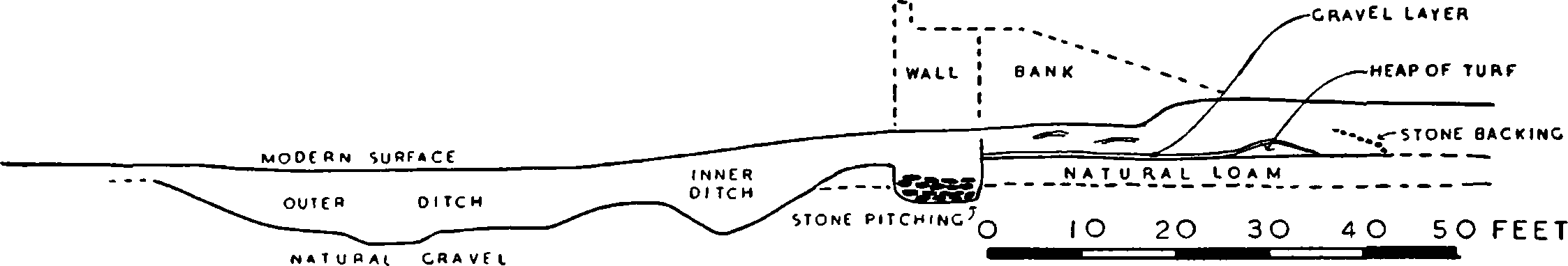
The Outer Ditch proved to be about 50-ft wide & 5-ft deep. The Inner Ditch was about 15-ft wide & 4-ft Deep. The Mollusca found in these 2-Ditches showed that both were permanently Wet; the Outer contained about 3ft or 4ft of Water and may have had a connection with the River Thame; the Inner Ditch had less Water and was overgrown with Reeds.
In the late-3rdC AD, the Earth Bank which had surrounded the Town for about a Century was replaced by a Stone Wall with an Earth Rampart. Over time, the tail of this Rampart slid back slightly to cover part of the Street behind. It was in this end of the Rampart overlying the Street that a small collection of Iron was buried, probably in a shallow Pit, at the very end of the 4thC or perhaps slightly later. Found during excavations in 1962, the Hoard consisted of a Ploughshare, a Coulter, a Chisel, a Spud (spade) and 10-pieces of scrap Iron (nail, bucket mount, binding fragments).
The Wall, which was separated from the Inner Ditch by a small Berm of about 6-ft, had been almost entirely robbed in later Ages, but enough of the Footings was discovered to show that it was about 9-ft thick at the Base & Sunk 2ft-6ins into natural Gravel. Behind the Wall in Section C were traces of the lower 2-ft of a supporting Bank faced with Stone Pitching. This Bank was 43-ft wide at the bottom and sloped up gradually towards the Top of the Wall, which was probably at least 15ft high.
A Pit thought to have been dug after the erection of the Wall (Section B) and a pre-Rampart Occupation-Ditch in Section C yielded sufficient stratified Pottery to date the construction of this System of Ramparts to about AD-125 or a little later. They remained in use, at least intermittently, until the 12thC, and the evidence of Stratified Potsherds in the filling suggests that the Outer Ditch was carefully cleaned out both in the 3rd or 4thC & in the 11th or 12thC.
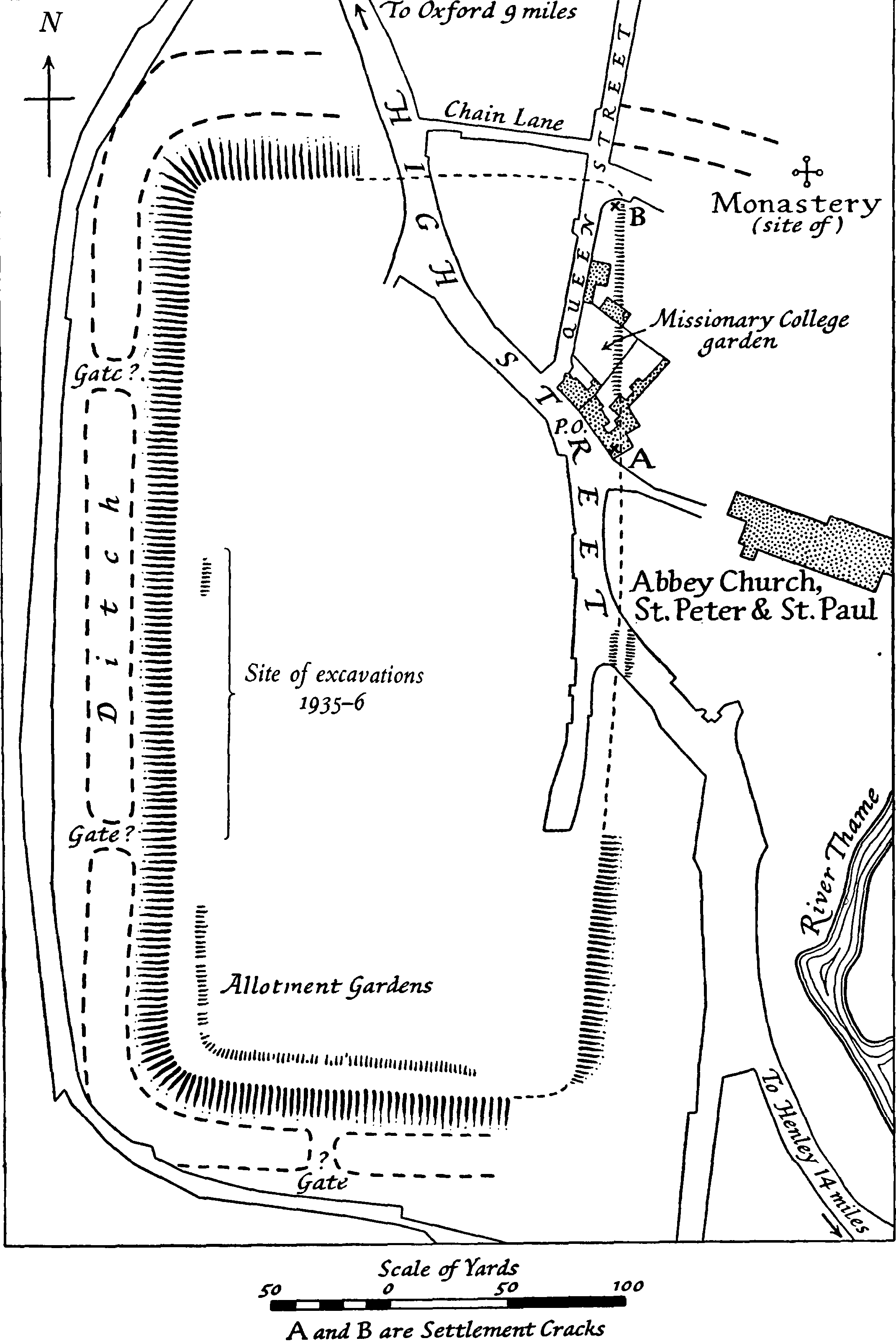
These Ramparts formed roughly a Rectangle of 13½-Acres, 375-yds long by 175-yds wide. The North-West, South-West, & South East Sectors are clearly recognisable from surface indications and it is only at the North-East that any doubt exists as to the approximate line they took. After the Modern Road from Oxford has entered the Outskirts of the Village, it comes to a Fork. The left-hand Branch forms the High Street of Dorchester: the right-hand Branch moves South West for about 200-yds and then turns South, straight along the Western edge of the Village. Having reached the South-West Corner, it bends at right-angles round the Allotments & runs East in a tortuous Course. The North-West corner of the Roman Vallum can be traced as a slight rise a few yards east of where this Lane changes direction from South-West to South. The Western Ramparts run from here due South, slightly East of the Modern Lane, and are plainly visible running through Gardens & Orchards. In the middle of the Allotments (Hemp Croft) the South-West Angle of the Vallum is plain, and its Southside runs due East until it picks up the Line of the front Gardens of Albert Place. These are on a Rise, supported by a Stone Wall, and the sudden change of Level must be attributed to the Roman Vallum and its accompanying Ditch. The South East Corner of the Ramparts must have lain under the East end of this Terrace, for North of this Point, the East Vallum is visible behind the Old Castle Public-house (Halls Brewery – No.6 BridgeEnd), running parallel to the High Street. Farther North is a Ridge in the same alignment crossing the High Street near the South-West angle of the Churchyard, and beyond this, 2 Settlement-Cracks in modern Masonry (A & B on the Plan) with a faint Ridge in the intervening Gardens seem to mark its Course. The North-East Angle is not traceable, but it must have lain at B on the Plan, where the Drive from the Vicarage & Manor House joins Queen Street. Thence the Line of the North Vallum took a direct Course parallel with and South of Chain Lane, across the High Street, to the North-West Angle
The Ditch outside the North Vallum is not visible now, but it occupied roughly the line of Chain Lane, and Barns saw it ‘very conspicuous at the Junction of Chain-lane with High-Street‘. Along the Western & Southern sides of the Town a broad though slight Hollow represents the Outer Ditch of the Defences. Outside the Eastern Vallum no trace of a Ditch can be seen. If a Ditch originally existed here it must have been filled up later when the Town was enlarged, for the Monastery & Castle stood outside it along the Banks of the Thame, partly on a raised Platform. There is some evidence that both the Southern & Northern Ditches extended direct from the SE & NE Angles of the Town to the River Thame, the former under the Roman Catholic Church, the latter under the Manor House. As both the Outer & Inner Ditches were Wet, at least one such extension must have existed, but even if both the North & South Branches had been made they would hardly have been accepted in full substitution for a Ditch along the Eastern Rampart. Such a Layout would make Dorchester unique amongst Romano-British Towns, and far stronger evidence is required than mere surface-indications.
We cannot at present fix the position of the Gates of Roman Dorchester & the Course of the Roman Road through the Town. The Plan shows 2-Causeways on the Westside and one on the South, interrupting the Ditch. Only Excavation could decide whether these marked the Sites of Gates, though they are in the right places: those on the West are at equal distances from the NW & SW Angle respectively, and that on the South is almost centrally placed. If there was a Gate on the Northside corresponding to that suggested on the South it would have been slightly to the West of where the High Street crosses the North Rampart, and in true alignment with the Road from Alchester. There is no reason to assume that the Road did not keep this Alignment and run straight through the Centre of the Town as it did at Alchester. As both Towns and their Connecting Road seem to have been Laid out Contemporaneously as part of a Concerted Plan, it is probable that the Layout of the 2 was, in such an essential, the same. Its Line after leaving the Town on the South is not certain. If the Ford between Dorchester & Shillingford was the only Passage across the Thames, the Road must have taken a right-angled bend Eastward to cross the Thame at or near the spot where the Medieval Bridge stood, and so join the Line of the modern Dorchester–Benson Road. But if there was an alternative Ford at the Confluence of the Rivers it may have kept its direct Course Southward. Not a trace of any Public Building of Roman date has yet come to Light at Dorchester.

Whiteland’s Farm, which is South of Bicester and Close to the Roman Town of Alchester. A late-Iron Age/Romano-British Settlement was confirmed with excellent finds, perhaps the most unusual of which was a Stone-lined Cistern for holding Water before Sluicing it into the nearby Stream. A gap devoid of features & finds between the Settlement and the nearby Roman Road was also intriguing, suggesting perhaps a Roman-Policed Buffer Zone.

B – Small Finds
The small finds, apart from those discovered during the OUAS Excavations in 1935/36, are all chance discoveries and are best listed in Categories. With the exception of such outstanding examples as the Broome Park Altar, the Vicarage Garden Cremation-Group & the 4thC Silver Spoons, they are of very Secondary importance.
Foundations of Buildings, Tessellated Pavements, etc
(a) In the Cellar of a House on the West side of High Street, opposite the Churchyard—a Tessellated Pavement; Taunt, Dorchester Guide, 3; OS. 6i. A note in OS Namebook says ‘some Roman Tesselated Pavement was Dug up here a few years ago by Mr Cobb‘.
(b) In Hemp Croft (Allotments, SW Corner of Village) – Bricks & numerous Coins; BBOJ iv, 80–Coins; Gough’s Camden (1806), ii, 28; OS 6in–Tessellated Pavement; Taunt, Dorchester Guide, 3.
(c) Near the Thames, West of Bishop’s Court–Rubbish-pits & one Tessera; BBOJ iv, 80.
(d) Beneath NE Chapel of the Abbey, 12-ft below surface–’Roman‘ Pavement, underneath which was burnt corn & bones; Oxf. Times, 4th June 1886; BBOJ iv, 80 (but ‘SE Chapel’ and no Pavement, only ‘charred corn’). Some charred remains (?-wood) from this find are preserved in the Ashmolean. It should be mentioned that the thin Red Tiles visible in the Interior Wall of the Abbey opposite the South Door, which are sometimes claimed as Roman (v. Kirkpatrick, Dorchester-on-Thame, p. 9), are certainly Medieval or later.
(e) Manor Farm Yard–cemented Cistern & fragments of several Urns; B.B.O.J. iv, 80.
(f) Dorchester Farm Field (Minchin Recreation Ground)–R/B Homestead(?), many intersecting Ditches on Air-photograph; BBOJ iv, 78; Antiquity, i, 472 ff. & pl. ii.
(g) Below Sinodun Hill (i.e. on Berkshire side?) – several Roman Buildings & Coins; Hearne, Roper’s More (1716), 258.
(h) No exact location – Tessellated Pavements; Gough’s Camden (1806), ii, 28; Brewer, Topography of Oxfordshire, 374.
Pottery & Habitation-Refuse
(a) In the Garden of Town House, c.1874, 7ft-8ft. below the surface – a great quantity of Pottery & numerous Coins, formerly ap. Wm. Cobb, Builder, Dorchester; BBOJ iv, 80; (?) Ashmolean Museum 1886. 1644.
(b) Below Foundations of Malt-house, Jordan’s Lane, 1886–Bronze antefix in form of a Female Bust, H-3¼-in, Bronze ear-ring (?-Medieval) and a large number of Bones & Pot-sherds; Ashmolean Museum 1886.799 a, b; BBOJ iv, 80.
(c) In the Churchyard, 5-ft below Surface – Samian dish (Drag. 79); Ashmolean Museum 1886. 1617 (formerly Wm Cobb Coll.).
(d) At Flixécourt, East side of High Street, opposite the Western Lane, 1934, behind Garage, 4ft-7ft. below surface – much Pottery in a Dump in pure Sandy Subsoil, some Vessels complete or nearly complete, mainly 2ndC; in possession of Mr Tegg, Flixécourt.
(e) Dorchester Farm Field, Borth of Minchin Recreation Ground, 1928 (East of BM 161, OS 6in.) 2-Habitation-Pits, with pot-sherds, tiles, ox-bones, etc; in possession of Mrs Hatt, Beech House. The Site lies South of the double concentric Circle on the Air-photograph, Antiquity, i, 472, pl. ii. On the same photograph is a Square Enclosure, facing East-West with Entrance at East, which appears to be Roman and is probably the enclosure mentioned by Brewer (Topography of Oxfordshire, 371) as visible in Crop-marks in Farm Field, Dorchester. Brewer thought it was a Medieval Church.
(f) Between Thames & Thame – Roman Pottery & Clay Lamp; Archictects Journal. xxiii, 73.
(g) South of Bishop’s Court—Roman Urn; OS 6ins. Details of this find are wanting: it may refer to the Greek Cylix found ‘near Bishop’s Court‘ (Ashmolean Museum 1893.168): v. p. 263.
(h) On Southside of Road to Benson, c.1920, about ½-mile from Dorchester – imitation Samian Mortarium and pot-sherds & bone pins, 4th–5thC; Ashmolean Museum 1932. 1228–9 & 1937.116.
(i) Manor Farm Rickyard – perforated base of Pot; Ashmolean Museum. 1893.167.
(j) In Mead Side Piece (left Bank of Thame), 1876 – great quantity of pot-sherds, including the mouth of a Vessel, Red ware, in form of a Female Head (Ashmolean Museum 1893.166); BBOJ iv, 79.
(k) No exact location – ‘Spear-head, sundry Urns & Lacrymatories‘(Tear Bottles) in possession of Mr T Smith; Gough’s Camden(1806), ii, 29 – ‘many examples of Pottery, especially Samian‘; OA & HS ii, 98 – fragments of 10-Vessels including part of a bi-Conical Pot of Grey ware, 1stC; Ashmolean Museum 1895.129 (given by Mrs A Blunt) – bi-Conical Pot, burnished Grey ware, 1stC; Ashmolean Museum 1921.7 (given by Rev N C S Poyntz).

Burials
(a) In the Vicarage Garden, SE of House, 4-ft below surface, 1866 – Cremation-Interment of c.AD200–50 consisting of:
(1) coarse Red Store-jar, globular, H 15¾-ins, D 18½-ins;
(2) Glass Bottle, 2-handled, yellowish-green, in shape of barillet but with trailed-thread decoration instead of horizontal ribs, H 7½-ins, D 2¾-ins;
(3) Glass Jug, one-handled, yellowish-green, with spiral corrugations on neck, H 9½-ins, D 4-ins;
(4) Glass Vase, broken;
(5) Lead Cup, in fragments; (6) fragments of sheep’s bones & charcoal. Nos. 2–6 were found within No. 1. Nos. 1-3, 5, 6 are in Ashmolean Museum (1886. 28–30); No. 4 is in the British Museum. PSA, 2nd ser., iii, 321; ibid. iv, 130; O.A. & H.S. ii, 98; B.B.O.J. iv, 80.
(b) SW of Town, in ‘Field of black soil’ – Inhumation-Burial consisting of 2- Urns with 2-Lachrymatories, Skull, and other human bones; Hearne, Diaries, iii, 175 (12 June 1711); Hearne, Leland’s Itin. (1710), v, 130. Hearne also notes many Coins & ‘variety of other remains of Antiquity’ from this Field & illustrates Coins of Crispus & Gallienus, ibid. The Field is probably not Hemp Croft (see above) but farther to the SW, as Hemp Croft was within the Rampart and consequently unlikely to have been used for Inhumation.
(c) In East Bank of Thames, just below Little Wittenham Bridge, 6-ft. below surface – several Human Skeletons, (?- Roman); BBOJ iv, 15; ibid. 78.
(d) In Dyke Hills – Inhumation(s?) of (?-Roman date); A H Cocks, Records of Bucks. x (1917), 26, describing finds of 1870/71, including Coffin nails, some of which are now in Ashmolean Museum (1936. 20, Rolleston Coll); OS 6in. (at NW. Corner of Dykes); Ashmolean Museum 1886.799 d, bone pin ‘found with human remains when Dykes were Ploughed down in 1870‘.
(e) In Mead Side Piece (left Bank of Thame), c.1874 – several Skeletons found in making a Drain, (?-Roman); BBOJ iv, 79.
(f) Near Bishop’s Court, c.1857 – 5-Skeletons, (?-Roman) (but see below, p. 351); BBOJ iv, 78.
(g) In Gravel-Pit, Dorchester Farm Field, North of Minchin Recreation Ground—inhumation Burial, consisting of:
(1) Skull and part of Skeleton;
(2) Bronze Key;
(3) Coin;
(4) Fibulae, and other objects; Pitt-Rivers Museum Rept. 1914 (OU Gazette, xlv), 658; Antiquity, i, 474.
Five Silver Spoons (Pl. XIII, f)
About ¼-mile SE of Dorchester, on left of Road to Benson, 1872, in digging Gravel, near the surface – 5-Silver Spoons of different Patterns; PSA, 2nd ser. v, 321; O.A. & H.S. iii, 124–5; B.B.O.J. iv, 79; O.S. 6 in. (but position inaccurately marked on right side of Road, ½-mile from Dorchester). Now in British Museum (1872.7.25 1–5, purchased). For some similar Silver Spoons found at Dorchester, Dorset, see O M Dalton in Antiq J ii, 89–92, who dates the Type to the later-4thC AS
Bronze objects
(a) Site of Girls’ School, 1869 – small conical object, beaten Bronze; Ashmolean Museum 1886.799 c.(b) No exact location – fibulae, rings, armillae, portions of Mirrors, handles of Vessels, portions of horse-Harness, chain Armour, 2 small Boxes with Screw-lids, small object inlaid with Gold wire (? the Trunk broken from a Figure of an Elephant); OA & HS iii, 170–1, coll. of J P Earwaker, Exhibited 1874, present whereabouts unknown.
Coins
(a) Manor House garden – 1 Æ, Trajan; BBOJ iv, 81.
(b) Manor Farm Field – 1 AR, Antoninus Pius, 1 Æ, Probus; ibid.
(c) Farm Field – 1 AR, Otho; ibid.
(d) South of Town (‘in the Closis and Feelds that lye Southly on the Town‘) – AV, AR, Æ coins; Leland, Itinerary ii, para. 11.
(e) In the Dyke Hills – ‘Roman Coins often found’; Gough’s Camden (1806), ii, 28; OS 6 in. (SW end of Hills: no details recorded).
(f) In Overy Field (or Close) – numerous Coins (1 Antoninus Pius, 1 Allectus); Hearne, Diaries, vi, 323 (30th March 1719); ibid. viii, 2 (29th September 1722); Gough’s Camden (1806), ii, 28.
(g) No exact Location – Gibson’s Camden (1695), 263; Plot, N.H. Oxf. (1705), 341; Hearne, Diaries, iii, 175 (12 June 1711); ibid. vi, 327 (3rd April 1719 – Constantine II); Pointer, Brit. Romana, 31 ff. (19-Coins, Vespasian-Magnentius); Salmon, Survey of England 478; Cox, Magn. Brit. iv, 426; Gough’s Camden (1806), ii, 28 (Mr T Smith’s Coll, ranging from Julius Caesar to Heraclius); Skelton, Oxfordshire, Dorchester Hundred, 2, & vignette, p. 10, & Addington, Dorch. Abbey Church, 51 (Ingram Coll., including 1 AV Mauritius, now in Ashmolean Museum); JBAA ix, 83 (1-Magnentius); O.A. & H.S. ii, 98 (chiefly 3rd & 4thC); BBOJ iv, 81 (a long list, some Cozens Coll., now in Ashmolean Museum); Records of Bucks. x (1917), 26 (250 in A H Cocks Coll., present whereabouts unknown); Haverfield MSS. (list of Coins, M. Aurelius to Arcadius, in OS Coll, Southampton).
Inscribed Altar
West of the Red Lion Inn, in Court (or Bishop’s) Close, 6-ft below the surface, while digging a Saw-pit, 14th June 1731, an Altar was Found. Shortly after its discovery the Altar (v. Hearne, l.c., & Horsley, l.c.) was bought by Sir George Oxenden, Bart, of Little Wittenham for a Guinea. By Skelton’s time (lc) it had been moved to Broome Park, near Canterbury in Kent, the Seat of Sir Henry Oxenden, Bart, and there it still was in 1913 or shortly before (Haverfield, Eph. Epigr., l.c.). A photograph Published in Country Life, 6th July 1907, fig. on p 22, shows the Altar standing in the Garden near the SE corner of the House. Shortly afterwards the House was Sold to the 1st Lord Kitchener, but the Altar was given away before the Sale and its present whereabouts is unknown. Hearne says that a Mr Fisher saw the Altar the day it was Found and gave him a Copy of the Inscription. Two days later a Mr Loveday, to whom Hearne had given Fisher’s Copy, made a revised Copy, and on 2nd October Fisher saw the Stone again and accepted Loveday’s revision; they both identified the Stone as Oolite from Headington Quarries. Judging from Gale’s sketch & Horsley’s engraving, the Altar had a Scalloped, waved Top and a Plinth Base, with Inscription set back between Mouldings above & below. Skelton (foll. by C I L) gives 3-ft by 2¾-ft. as the overall dimensions: Horsley’s engraving (if 1/8th scale, as usual) makes it 3-ft by 2-ft. The Inscription ran: [Iovi] O[ptimo] M[aximo] et Numinib[us] Aug[ustis] M[arcus] Var[ius] (or Vatr[ius]) Severus B[eneficiarius] Co[nsulari]s Aram cum Cancellis d[e] s[uo] p[osuit]
Marcus Vatrius Severus, a beneficiarius consularis, set up at his own Expense this Altar with its Railings to Jupiter Optimus Maximus & the Deity of the Emperor.
Haverfield (Eph. Epigr., & MS. notes) verified this Reading from a squeeze sent to him, and preferred Varius to Vatrius in Line 3. The cancelli were presumably Barriers round the Altar (Dessau, ILS, 4423, 5647; Thes Ling Lat, s.v.). A beneficiarius consularis was a Legionary Soldier promoted to a Special Office, in Rank just inferior to a Centurion. He seems to have served in detached Posts on important Routes, at Cross-roads and near Frontiers, where Customs Dues, and in the 3rdC Taxes in kind for the use of the Army, were Collected, and also to have been concerned in preserving the Public Safety by Police-work. Other instances of such Officials in Britain include: Catterick in Swaledale (Altar to God of Roads & Tracks, Dessau 3929); Binchester (id 4785) & Lanchester (C I L vii, 441), both Traffic Centres on the Main North Road; and, in the South, Winchester (C.I.L. vii, 5; VCH Hants, i, 291 f). Von Domaszewski (op cit) goes wrong, however, in thinking that the Dorchester beneficiarius was to control a Road from London to Caerleon: no such Road via Dorchester existed. Haverfield suggests that Dorchester may have been the Junction where Water-traffic Westwards took to the Land. Certainly the strategic importance of Dorchester was its position on the Thames, and if our Beneficiarius controlled any Crossing it was a Road-River one, and not a Crossroads: but he may have been concerned in Policing a Market or a Group of Agricultural Villages (not, of course, a Saltus), and Controlling the Transport. Haverfield, judging from the shape of the letters and the mention of Numina Augusta, ascribes the Altar to the Late-2nd or early-3rdC.
C – History: The Excavators of 1935/36 found, beneath the remains of the Rampart in Section C, a small Drainage-Ditch and some Rubbish-Pits which may have been contemporary with it. The Pottery in this early Ditch belonged to the Claudio–Neronian Period, and as the Ditch yielded, besides coarse Native Pottery, fragments of early Samian, bits of Daub, and a scrap of painted Wall-plaster, we have evidence for an early, pre-Rampart Occupation on the Site, dating from the time of the Conquest or shortly afterwards. A biconical Pot of a mid-1stC Type and another fragment of a similar Vessel, as well as numerous Coins of the later 1stC, had previously hinted at such an early-Occupation, but their exact find-spots were unrecorded. As there is even stronger evidence for dating the Foundation of the Sister Town of Alchester to this same Claudio-Neronian Period, it is a fair assumption that the Road connecting the 2 was Constructed Contemporaneously and that the whole Complex forms part of a Concerted Plan laid out to Facilitate the Provision of Supplies to the Frontier Line. The importance of Dorchester on this Route was that it occupied a strategic position at the Confluence of the Thames & Thame, and at the same time formed a Guard-Post against the strong British Settlement nearby.
The Ramparts of Dorchester, with their 2-Ditches, Stone Wall, & supporting Bank, were Constructed about AD-125. They appear to be contemporary with those of Alchester, and both Towns must have been quickly Consolidated like most others in Roman Britain, during the early-years of the 2ndC. Certainly at Dorchester finds of 2ndC material have been plentiful.
To the early-3rdC probably belong the important Roman Altar, and the Cremation-group found in the Vicarage Garden. These inform us that Dorchester was not only a flourishing little Settlement – the 2-Glasses are of Seine-Rhine ware, Imported – but also contained an Official who could set up an Altar in good Latin. It had become a Market & Traffic Centre for the numerous small Riverside Villages around & about. The abundance of 3rd & 4thC Coins from the Site and the frequency of Pottery of late-Roman date suggest that this prosperity continued up to the last days of Roman Britain. It was probably not discontinued even then, for it is unlikely that, had the Town been Deserted at the 1st Onslaught of the Saxons, a New Town would have arisen on the same Site and become so important by the 7thC that Birinus chose it as his Diocesan See. It was perhaps the very continuance of the Town as the Stronghold of what was left of Romano-British Civilisation that Led Birinus to it and it is even possible that some trace of Christianity itself had survived within its Walls to welcome him.
Villages & Other Communal Occupation-Sites
Upwards of 35-Sites in the County have produced signs of permanent occupation by Large or small Communities. They were hardly Villages so much as Settlements of People who had come together for the purpose of Trade, Industry, or Agriculture. All, with 1-Exception, lie either in the Valleys of the Thames & Cherwell or along the 2–Roman Roads that traversed the County. The apparent Exception is the Blacklands Site at Swalcliffe which, if it is not more rightly to be considered as one or more Large Villas or Farmsteads, is in any case a near neighbour to the Cherwell Valley Sites at Bloxham, Banbury, Deddington, etc and is itself situated on the Sor Brook, a Tributary of the Cherwell. On the other hand, the Villa & Farmstead Sites lie predominantly on the Uplands. These communal Occupation-Sites may be divided into several categories. In only one instance, that of Wood Eaton, are the remains found sufficient to justify Independent treatment here.
1 – Sites where Excavation has revealed Huts, Pits, or Ditches
Three of these, Mount Farm, Dorchester, Chesterton Lane, Bicester & Sandy Lane, Yarnton, were overlap-Sites occupied continuously from Early-Iron Age to Romano-British times (see further under (3) below). Others, e.g. Blackthorn, Headington & Blenheim Park, Woodstock, have revealed Occupation-debris of the 1stC AD only; the Pottery is coarse ware of Iron Age Ancestry, and they were presumably occupied by Native Britons of the Conquest Period. The 1st 2 adjoin Roman Roads and may well have been occupied for a short time by Conscript Road-Builders; the 3rd is even more interesting, for the situation of its Occupation-layers, either under the Bank of Grim’s Dyke or at the bottom of its Ditch, suggests that they were the Hutments of Britons engaged in the actual Building of the Dyke; in any case the early-1stC pot-sherds found in them have proved that the Dyke, at any rate the Blenheim Park Sector of it, was Built in the 1stC and not later, perhaps as a Defensive work against the Roman Advance. The remainder of the Sites that fall under this Head are later in date. That at Cutslow belongs to the late-1st & early-2ndC; Eynsham (Site 2), one at Shipton-on-Cherwell, and others at Shotover belong to the 2nd-4thC AD.
2. Settlement-Sites with Burials
To this Class belong 6 Occupation-Sites to which Cemeteries are known to have been Attached. Three are noteworthy. At Cassington, West of the modern Village, recent Road-works & Gravel-digging revealed a large Cemetery containing upwards of 100-Graves of late-Roman date. Near the Inhumation Cemetery, at least 1-Cremation-pot of earlier date has been found, as well as a few Occupation-pits and many Sherds scattered in the surface Soil. As the Site has also provided remains of each Prehistoric Age from late-Neolithic onwards, as well as several early-Saxon House-floors, it is likely that this Gravel-patch at Cassington has been occupied in continuity from Neolithic to Modern Times. The same is probably true of other Oxon Villages, but it has been demonstrated nowhere else. At Benson remains of Roman Occupation have been recorded in different places within the area of the Modern Village; the Cemetery was apparently on the East of the Modern Site, the Occupation-area to the West & South nearer the Thames & Medlars Bank. No 2ndC Occupation has been identified here, but this is perhaps fortuitous; if Settled at the end of the 1stC it seems unlikely that it would have been Abandoned during the 2nd and then re-Occupied. At Bloxham, in the North of the County, on a Tributary of the Cherwell, the Site Excavated by W F J Knight in recent years has revealed an intensive Occupation, with Coins & Pottery of the 1st–4thC AD, numerous Inhumation-burials of late-date, and Rubbish Pits, but no trace of Occupation-Pits or Hut-floors. It has been suggested that the Settlement was Industrial, connected with Ironstone working, but no traces of such activity were found; it would appear rather to have been a Rural Village of Mud Huts. Among other Sites that fall under this Head are Blackingrove Farm, Barford St Michael, Military College, Cowley, & Parish Pit, Deddington; all 3 are ill-recorded, but they have yielded Pottery & Inhumation-burials.
3. Settlement-Sites of Potters
On the 2-most recently recorded Sites of Pottery-works in the Oxford District, those at Rose Hill, Cowley, and at Allen’s Pit (Burcot), Dorchester, Traces of extensive Settlement (Pits, Hut-floors, Ditches, & the like) were found.
4. Crop-mark Sites
In 1899 Professor Haverfield published a list of low-lying Sites in the Upper Thames Valley where he, or others, had noticed marks of Circles, Rectangles, & Parallel Lines in the Crops similar to those of the Northfield Farm Site at Long Wittenham, Berks., which was proved by Excavation to be of Romano-British date. The List he gives includes, in Oxon, Foxley Farm, Eynsham, Fullamoor Farm, Clifton Hampden, Culham, Gould’s Grove, Benson, Kelmscott, & 5-Sites near Dorchester. Recently many of these Sites have been photographed from the Air by Major G W G Allen and Haverfield’s Judgement has been justified to the full. Major Allen has added 4 more to Haverfield’s List: one at Wally Corner, Dorchester, one SW of Cokethorpe Home Wood, Ducklington, one at Southfield Barn, Eynsham and one near Linch Hill, Stanton Harcourt. All reveal from the Air, under suitable conditions of Crops, intricate patterns of Rectangular Enclosures & Parallel Ditches, as well as Pits & small Circles. At 3 of them (Ducklington, Eynsham, Stanton Harcourt) the evidence of Air-photography has been corroborated by the finding of early-Romano-British Pot-sherds. As some, if not all, of these Sites have also revealed evidence of Iron Age, and even earlier, Occupation, it seems as if in them we may see more examples of such overlap-Sites as Mount Farm, Dorchester & Yarnton, mentioned under (1) above. All, it should be noted, are situated on Gravel by the River Bank in the situation beloved by the pre-Roman Inhabitants of the District.
5. Pottery & small Objects suggesting Communal Habitation but no trace of Pits or Dwellings
All the Sites referred to under this Head have been very ill-explored, but such evidence as they have supplied suggests that they were Communal Sites rather than Villas or Farmsteads. They are: Adderbury (Ridgeway Field); Bloxham (Sites 3 & 4); Cowley (New Conservative Club); Headington (Sites 1 & 2); Shotover (2-Sites); Tackley (Beech Hill Clump & another); Wilcote (Site 1); Wolvercote (Pear Tree Hill); Wychwood.
6. Communal Sites of Indeterminate Type
There are 2-Occupation-Sites in Oxon – Swalcliffe & Wood Eaton – which cannot be ascribed, on the evidence available, to any one of the foregoing 5-Groups. In each case the area over which the remains are found, though large, can be definitely delimited; and in each case the finds, though consisting mainly of Potsherds & small objects found casually in the Top-soil, include definite traces of Buildings of Romanised Character, with Rubbish-pits, etc, besides. At Swalcliffe the area covered is upwards of 50-acres and apparently included, besides a Stone-built House with Mosaic Floors and a Tiled & Slated Roof, some Stone-built Ovens or Furnaces, and a Well; the Roman Occupation extended from the mid-1st to the 4thC but was more intensive from about AD-250 onwards. At Wood Eaton the area covered is again at least 50-acres (Middle & South Hill Fields taken together make upwards of 80-acres), and the available evidence suggests that there were a Stone-built Inclosure and an elaborate Building of some sort with Walls covered with painted plaster; Mosaics are not recorded but Tesserae & Tiles have been found. The occupation once more extended over the whole Roman Period, and, on the evidence of Pottery & Coins, was more intensive during the latter half of that Era.
Moreover, both Sites appear to have been the direct Heirs of Early-Iron Age Settlements. The Iron Age Camp of Madmarston lies immediately West of Blacklands Field; and at Wood Eaton, British Coins, Iron Age Fibulae, and much Pottery of Iron Age A-Types have been found nearby, between the Roman Site & Wood Eaton Village. Both may well have been Native British Settlements, engaged in Industry or Trade, which became more or less Romanised. Their apparent increase in size & prosperity in the 3rd & 4thCs AD is typical of non-urban Sites all over the Civil area of Britain; the decay of the Towns and the growth of Rural life naturally brought with it an increased necessity for such Rural Centres of Trade & Industry.

Dorchester-on-Thames is a Key Site in British History. It is the only Site in the Country that has seen Towns dating from the late-Iron Age (100BC – AD43), the Roman & the Anglo-Saxon Periods which have not been obscured by later Development. Since 2007 a Partnership of the School of Archaeology at the University of Oxford, Oxford Archaeology & Members of the Local Community, have been Investigating these Sites, forming the long-term ‘Discovering Dorchester’ Research Project. Investigations at Dorchester will allow us to gain a better understanding of 4 of the Key Transition Points in English History: the Origins of Agricultural Societies in the Neolithic; the growth of Urbanisation & Movement away from a Tribal Society in the late-Iron Age; subsequent Incorporation into the Roman Empire; and the rise of an early-Medieval Centre from the confused situation which followed the severance of Britain from Western Roman Administration in the 1st Decade of the 5thC AD. The Dorchester Excavations thus far have been conducted at Minchin Recreation Ground, a later Roman Enclosure & Bronze Age Ring Ditch (in 2007), Burcot Brook Car Boot Field, recovering the Vestiges of a Neolithic Cursus & Bronze Age Ring Ditch (in 2010 to 2012) and the Dorchester Allotments, formerly the Hemp Croft (2008 to present) which represents the South-Western Corner of the Walled Roman Town. The Village of Dorchester lies just off the A4074 between Berinsfield & Shillingford; the Allotments Excavation Site is in the Southwest, off Watling Lane (grid reference SU577941). This Site has been chosen in large part because it has never seen post-Medieval Development and because Professor Sheppard Frere’s investigations in 1962-64 revealed tantalising clues to what might have been occurring in this part of the Town. Whilst S S Frere was limited to small Trenches between Cultivated Plots, the Dorchester Project has been given a 30M x 20M space for open-area Excavation.
Project Directors
The Directors of the project are: Paul Booth (Oxford Archaeology) Professor Chris Gosden (Institute of Archaeology, Oxford) Professor Helena Hamerow (Institute of Archaeology, Oxford) Dr Gill Hey (Oxford Archaeology) The Assistant Director of the project is: Edward Peveler (Institute of Archaeology, Oxford)

In 1874, during Levelling Works on the Eastern part of Dyke Hills, the Ramparts of an Iron-Age Oppidum outside Dorchester-on-Thames, Workmen discovered 2-Graves – 1-male, 1-female – dating to the very end of the Roman Period in Britain. The Bronze Artefacts from the Burials came to the Ashmolean in 1886, but any other material has been Lost. We know that there were several pieces of Iron, including a Knife, that were thrown into the River. The Male Burial contained a large number of Bronze objects which formed part of a late-Roman Military Belt Set. The objects include a Buckle, a Strap end, 4-Attachments with Suspension Rings, 11-Belt stiffeners & 2-long, Flat Plates originally attached to the ends of the Belt. These Attachments are fairly plain, though the D-shaped Loop of the Buckle ends in simple, stylised Animal Heads with open mouths full of fearsome, pointed Teeth. This sort of Belt is very rare in Britain and most of our knowledge comes from the Continent where these Belts were made and where they are much more common in late-4th & early-5thC Cemeteries along the Roman Frontier (Limes) in Northern Gaul & along the Rhine. They belonged to Soldiers living in these Regions & responsible for the Defence of the Frontier Regions.

A Germanic Origin for the Dorchester Man has been proposed based on his reported large size (estimated at time of discovery at 6-ft) and by 2 distinctively North-German Brooches found in the associated Female Burial, which also contained a Buckle, suggesting her Identity as the Companion of a Military Man. It has been assumed that the man was one of the Troops brought from the Continent to Britain either by Theodosius (inset) in AD368-369 or Stilicho in AD398-399 and that these Troops brought their Women with them. However, the Skeletal remains have not survived and the evidence of the finds is not conclusive about a Germanic Origin for the 2-People. The material is clearly Roman in date, meaning that we must see the People buried in these Graves as having been Associated with the Roman Army rather than as Saxon Settlers, which appeared in Britain slightly later. The Man is likely to have been Garrisoned at Dorchester for the Protection of the Town, probably during the Final Phase of the Roman Occupation of Britain. There is also evidence for Military Personnel in the Countryside, for example at Shakenoak, nr Witney, though their Role there is less clear. During efforts to restore a Section of the Monument in 2010 the Dorchester-on-Thames Research Project found a Burial with 2-Pieces from a similar Belt Set & an Iron Throwing Axe (Francisca). These have been very kindly donated to the Ashmolean by the Landowner and are now on Display alongside the 1874 Dorchester Belt in the ‘England 400-1600’ Gallery.
The Destruction of Ancient Monuments, such as Dyke Hills, inspired the creation of the Ancient Monuments Protection Act, passed by Parliament in 1882. It was the 1st Law to protect Archaeological Sites in England and included in its Original List Stonehenge, Avebury & The Rollright Stones. Though Dyke Hills was one of the earliest scheduled Ancient Monuments and is still under Protection, it is a very vulnerable Site due to Ploughing & extensive burrowing of Rabbits.
Roman Roads


Roman Pottery

a. Longitudinal Section through Stoke-hole & Furnace-chamber.
b. Cross-section through Furnace-chamber.
c. Ground Plan of Stoke-hole & Furnace-chamber.
d. Ground plan of Pot-chamber.
The Pottery from the various Waste-heaps, combined with the Fragments found in the Actual Kilns, gives a very fair conspectus of the Ware which these Factories made, and thereby of the inclusive date of their activity. May has analysed in detail Vases & Fragments from Sandford, which include the following varieties:
1. Imitations of early Samian shapes in hard Grey Ware or soft Red Ware, often with White Barbotine or with combed Linear Patterns of the 1st or 2ndC.
2. Ollae, Bowls, Dishes & Beakers of Grey Smother-kiln Ware, often coated wholly or in part with Bitumen, and dating from the 1st to the 4thC.
3. Jugs, Amphorae, Bowls & Mortaria of White Ware, dating from the 2nd to the 4th or early-5thC.
4. Bulbous Beakers, resembling Castor & New Forest Types, often decorated with rouletting, thumb-indents, or barbotine; Rosette-stamped Bowls with vertical sides; Mortaria imitating the Samian form with Lion’s-head spout; Bowls imitating Samian forms all of Red Colour-coated Ware of various dates from the 3rd to the early-5thC.
A Cemetery Site at Queensford Mill, Dorchester
In February 1972 , Amey Gravel Company reported to the Upper Thames Archaeological Committee that clearance of Topsoil at their Pit at Queensford Mill (SU 582949) prior to Gravel Extraction had exposed a number of human bones. Upon Inspection the Site was identified as a Cemetery of uncertain date. The Gravel Company agreed to allow Excavation and a fortnight’s work on the Site was possible. The Excavations were sponsored by the Oxford City & County Museum & the Upper Thames Archaeological Committee
