
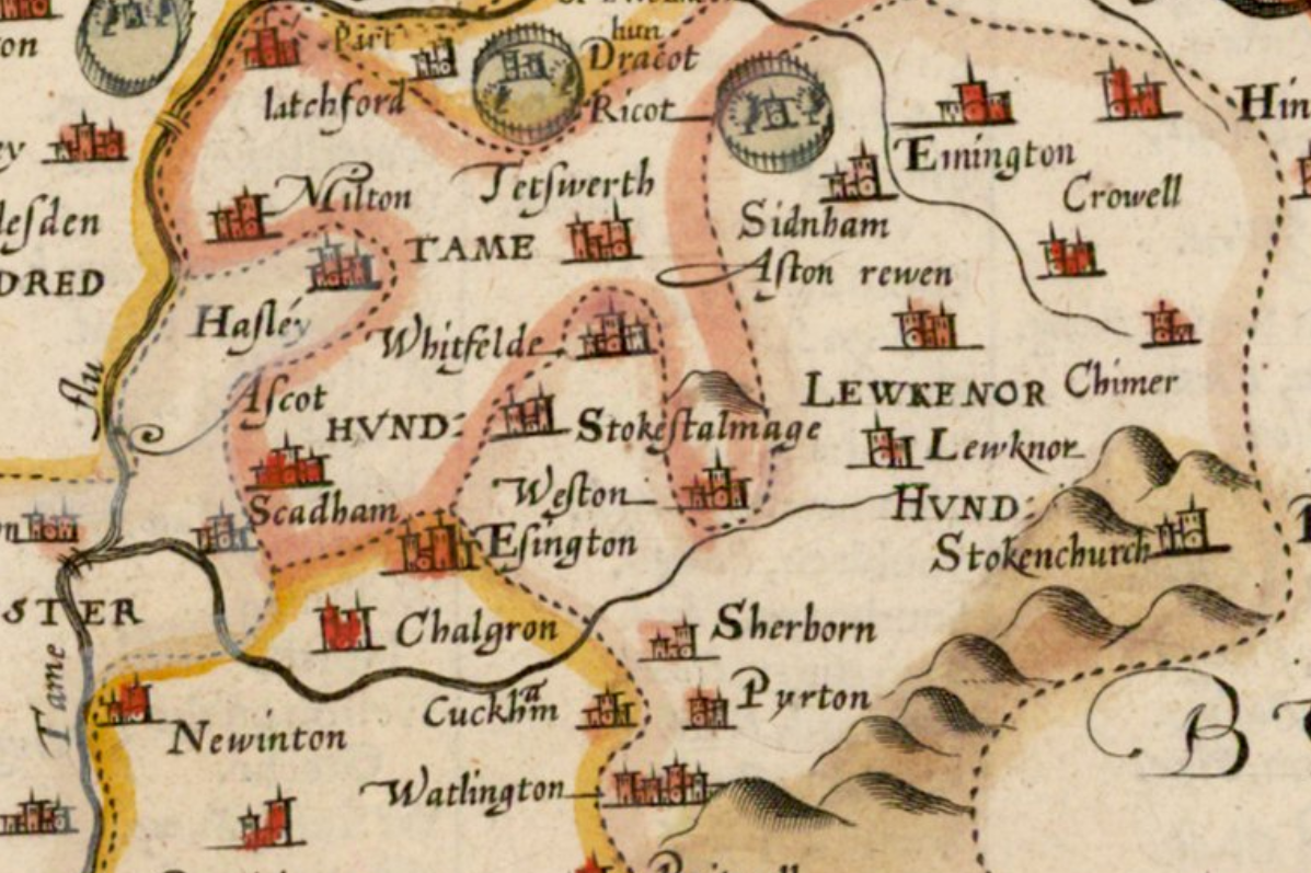
The Ancient Parish of Pyrton stretched for about 12-miles diagonally between the Chilterns in the South-east & the adjoining Clay-lands to the North-west, varying in breadth from ½-mile to 1½-miles. Until 1896 the Parish consisted of 2 detached Portions, the Northerly running from Haseley Brook Southwards as far as, but not including, Christmas Common & the Southerly running from just South of Christmas Common to the Southend of Stonor Park & the County Boundary, some 3½-miles North of Henley. The total area of the Ancient Parish, at least since the 12thC, was 4,847 acres & included the Tithings & Hamlets of Standhill, Clare & Goldor in the Northern Section and of Upper Assendon (now known as Stonor) in the South. Portways was never a Tithing & was Settled in comparatively recent times, perhaps not before the 16thC. In 1896 the detached Southern portion of the Parish, covering 1,541-acres, was formed into the separate Parish of Stonor & in 1922 was united with Pishill Parish to form the Parish of Pishill-with-Stonor. In 1932 the United Parish lost 211-acres to Watlington & so came to cover 3,292 acres.
Assendon Tithe Map 1850
Pyrton Township Tithe Map 1850
Golder Township Tithe Map 1850
Clare Township Tithe Map 1850
Standhill Hamlet Tithe Map 1840
The greater part of the Ancient Parish lies within the 250–350ft Contours, rising in the North to a small Ridge, on which lie what is left of the Hamlets of Goldor & Clare & then Descending towards Haseley Brook & the Site of Standhill Hamlet. Farther South, the Chiltern Escarpment bisected the Ancient Parish & from about a mile South of Pyrton Village, the ground rises steeply to Pyrton Hill & Christmas Common (785-ft). Farther South still, the Hills descend again through a belt of Woods, to about 325-ft at Stonor & 250-ft at the Southern Tip of the Parish. It is possible that the Parish originally included Easington & Warpsgrove, in which case its Northern half would not have been so markedly narrow as it is now & it almost certainly included part of Pishill at its Southern end until shortly after Domesday. All that is certain, however, is that Pyrton had its Origins in a Saxon Estate of 40-Hides. The Boundaries of this Estate are given in a Charter of 774, preserved in Hemming’s Cartulary, of which the relevant parts were written in the 1st-Half of the 11thC. 2-Sets of Boundaries are given for what are evidently adjacent parts of the same Estate, & the identification of certain Landmarks makes it possible to suppose that one Set of Boundaries may still be approximately represented by the Modern Parish Boundary of Pyrton & the other in part by the Modern Parish of Pishill-with-Stonor. Identifications are difficult in the Chiltern End of the Parish, but in the Northern half they include Pyrton Heath (on pone haep), Haseley Brook (roppan broc), Cripshill, surviving into modern times as a Field name at the North-east corner of the Parish & Knightsbridge (cnihta bricce), surviving as Knightsbridge Lane. When once the Parish Boundaries had been Established Annual Perambulations preserved them unaltered for Centuries, although Tithe Cases show that there might often be some doubt about a Parish’s claim to particular pieces of Land. Such a doubt existed in 1617 about Lewknor Mead on the Boundaries of Pyrton & 3 other Parishes. Boundaries were marked by Boundary Crosses cut in the Soil which were preserved as late as the 18thC.
High in the Chilterns alongside Pyrton’s most Ancient Road, called Knightsbridge Lane or ‘Ruggway‘ a Ridgeway Spur which was the Main Road from Henley to Watlington until the 1880s
Pyrton Drift Way: The word Drift is an alternative to Drove & occurs most often in East Anglia – but we have what was known as the Pyrton Drift Way in Oxon. On modern Maps it is now known as the Oxfordshire Way, a long distance Footpath that has suitably taken over the Mantle of an Old Route. It has been suggested that although the Route was used by Local Farmers in the Vale to move their animals on to the Escarpment in the Summer at Christmas Common & Turville Heath, it was also used by long-distance Drovers coming from Worcester via Chipping Norton, Islip & Wheatley. Instead of following the Line of the A40, they cut diagonally across the Vale by way of Haseley to Pyrton via what is now the Stoney Lane Bridleway & Knightsbridge Lane & the Base of the Scarp. The obvious Route up the Scarp is by way of Watlington Hill, which leads directly on to Christmas Common & Northend (to the South-east) where there were Commons, large Ponds & Pubs.

Here they might have taken 1 of 2-Routes, possibly from Christmas Common via Hollandridge Lane to Stonor & then Henley with its River Crossing & Markets. The other possible Route was from Northend via Turville Heath along Drovers Lane to The Drovers pub at Southend (now closed) & down the Hambleden Valley to the River Thames. Why would they do this? – to Avoid Tolls is the obvious answer & to Avoid the Town of Wycombe & its busy Stream with its Mills. They may also have earned Rights of Passage. The Route Avoids the Town of Watlington by crossing the Main Road & joining up with the Icknield Way, the Section directly below Christmas Common. This short stretch has one Hedge on just one side of the Track – but this is Dense & Thick & very Wide & a distinct Barrier to the Fields behind. It is full of Wildlife, & is a pleasant Walk in the Summer. Drove Routes had Hedges to avoid contact with Local Livestock, but Tracks through Land without Animals did not necessarily require a Hedge – hence the single example. Local Drove Routes up from the Assendon‘s to Southend & Summerheath, or from Lewknor & Chinnor, occur all the way along the Scarp in Oxon. Any one of them could have been Adopted by the Seasonal Welsh Drover. Steep Hills presented no problem as the Cattle were reared in a Mountainous Landscape.
Oxfordshire Way – Pyrton to Christmas Common


Pyrton’s most Ancient Road, Knightsbridge Lane or ‘Ruggeway‘ (Ridgeway), as it was called in the Middle-Ages, is no longer used as a through Road, though it is still the only Road to Hollandridge Farm. The Saxon name & its position in relation to the Parish Boundaries suggest that it might be far Older than the early-13thC when references to it 1st occur. It runs North to South right through the Parish from Haseley Brook, where as Late as the 18thC there was a ‘well-known Ford & Foot Passage called Standelf Bridge‘, to Stonor, where it joins the Road to Henley. For a short part of its Course it forms the Parish Boundary, but in the main, it lies Centrally between the Boundaries & Parallel to them. Its significance in Saxon times remains a matter for speculation, although the Military value for those who would pass from the Oxfordshire Plain to the Thames at Henley without Forcing the Goring Gap must have been as obvious then as it was in Later times. In the Middle-Ages, it might have been a Route from the Thames Valley at Henley through to the Old Road to Worcester via Islip. Henley was of great Local importance as a Market, particularly for Corn & so was its River Traffic. Every sort of Supply for the Great House at Stonor, for instance, came by Barge to Henley from London. This Knightsbridge Route, combined with the nearness of the Royal Roads by Henley & Wallingford to Oxford & Woodstock, must have continually exposed Pyrton to the mixed blessing of Royal Purveyances.
Knightsbridge Lane in 1960 was, at the Northern end, no more than a Gated Cart-track through remote Pastures, though as Late as 1910 it was described as a ‘High Road‘. Below Pyrton Hill, it is crossed at right-angles by the Icknield Way. Two Roads shown on the Map of c.1720 have now vanished: a Road from Clare to Shirburn & one from Wallingford to South Weston. The basic pattern of Roads, however, remains Medieval & none of modern importance traverses the Parish.

A Minor Road coming from the Main London Road crosses from East to West, linking Tetsworth & Chalgrove & the Lewknor-Watlington Road crosses the Parish at its narrowest point, near Pyrton Village & still proves a useful Route for Motorists travelling from the Upper & Middle Thames Area towards East Anglia. The Branch Railway Line from Princes Risborough to Watlington, Constructed in 1872, crossed the Parish just South of this Road, with Watlington Station on the Pyrton Boundary. Plans were made, though not fulfilled, to Link this Line with Wallingford. In 1957 the Line was Closed for Passenger Traffic.
The Villages of Pyrton & Stonor (or Assendon), lie along the old Knightsbridge Road, but though it may have influenced the choice of Site the availability of potable Water was clearly the deciding factor in the case of Pyrton & all its subsidiary Hamlets. Pyrton itself was a fair-sized Village for this part of the County & a Map of 1730 depicts 21-Dwellings besides the Manor House & Parsonage. Four of the Farmhouses are bigger than the rest of the Villagers’ Houses & this agrees with the Picture given in the Hearth-Tax Lists of 1665 where 4-Farmhouses had 3 or 4-Hearths. There is evidence suggesting that the Plan of the Village may have been altered in the course of Centuries. When Richard Symeon took a Cottage with 3-acres of Land & a Holding of 3-Virgates in 1571 he was allowed to move the Cottage to Land beside his own House.
The secluded position of Pyrton Village & single Ownership has enabled it to preserve its Ancient Character. There has been no 20thC Development & many Picturesque Houses of 17th & 18thC Date, Built of Local Materials & in the Traditional style, Survive. A Row of them (Magpie Lane) was burnt down in 1934. The Rectory, Vicarage, Farmhouses & Cottages are clustered around the Church & its Churchyard, which is beautified by fine trees, among them were many Elms dating from 1805 when 40 were planted.
OS Map 1919 St Oxon XLVII.10 (Pyrton; Shirburn)

On 2nd September 1943 a Vickers Wellington Mk IC Bomber Aircraft, R1451 of No.11 Operational Training Unit RAF Based at RAF Westcott, Bucks was on a Night Training Flight when it Crashed at Pyrton. All 5-Crew were Killed. The Pilot & 3 of his Crew were Members of the RAAF. The Wireless Operator, Sgt FW Nixon, was a Member of the RAFVR. The cause of the Crash was never Established.


The Manor-House lies in its Park to the South-west of the Church & is approached by a Drive from Manor Lodge, a picturesque 17thC Cottage of Brick & Flint with a Thatched Roof. It is a typical Elizabethan E-shaped Building of Red Brick with Stone Dressings & dates in all probability from the time of Edmund Symeon, Farmer of the Manor from about 1605. It was here that John Hampden Courted Elizabeth Symeon whom he married in 1619. The Medieval Predecessor of this House is likely to have been Built on a slightly different Site, that where the Moat now is. There is a Record in 1422 of the Vicar’s Leasing the Fishing in the Pools & Ditches around it. The Elizabethan House was a fair-sized Gentleman’s Residence as the return of 14–Hearths for the Hearth Tax of 1665 indicates. The House & its Grounds are depicted by Burgess on an Estate Map of 1738 made for the Tenant William Perry, Esq.
A Survey of the Lordship of Pyrton in Oxfordshire… by William Burgess. 1738. Scale ca. 1:3,400. Manuscript tracing ca. 1900.(R) MS C17:49 (181).
The House is shown with 4-Chimneys & a Formal Courtyard on the Eastside, a Grove, Pond, & Orchard to the South-west, a Dove-house & small Pond to the North. In 1781 it was bought by Hugh Hamersley & in 1786 ‘Heavy’ Repairs were carried out to the Mansion-House as well as to the Farms & Buildings on the Estate which were ‘very numerous & crazy‘. Part of the Drawing-room Chimney had fallen down, the Front wall of the Wings over the 2-Venetian Windows was ‘much Bulged‘ & part of the Front Wall had parted from the Party Walls, as the Foundations had given way. The Roof of the Servants’ Hall had fallen in; the Tiling of the Roof needed immediate Repair; most of the Wainscotting (Low Panelling) needed to be renewed.

The Windows of the South-east Front of 5-Bays & of the flanking Gabled Wings of 1-Bay are now all Sashed, dating from the 18thC & later. A View of the House in 1820 shows 2–Venetian Windows at 1st-Floor Level, one in each Wing. These were replaced by Sashes when the House was Modernised in 1939. Two flanking Chimney Stacks, each with 3-Diamond Shafts of Brick, are Original features. The House is entered through a 2-Storey Porch with Battlements & a 4-centred Doorway with Carved Spandrels. The Northwest Front has not been Modernised: it is irregular & has 4-Gabled Dormer windows, Chimney Stacks with clustered Diamond Shafts, & the original windows with Stone Mullions & Dripstones. Inside, the Original Newel Staircase with Double Bannisters remains & much of the early Panelling.


At some date between 1738 & 1792, the Grounds were Landscaped in accordance with the Fashion of the Period. The Dove-house & small Pond to the North of the House were replaced by a large Ornamental Lake edged with Trees; an Avenue was planted along the approach to the House from the Village Street; to the South-west the Pond of 1738 had given way to a Large Lake with 2-Islands in the Middle.
Shooting in Pyrton: The Estate of Mr E Hamersley Furnishes an example of the results accomplished by careful Preserving. This Property, which lies near Watlington & practically at the Foot of the Chilterns, extends to about 850-acres, of which some 500 are kept in hand, while the total Acreage of Cover amounts to some 35-acres. Yet on this small area, the total Annual Bags are seldom less than 3,000-Head & in the Season 1899–1900 reached 7,000-Head, made up of 580-pheasants, 257-partridges, 146-hares, 6,107-rabbits, 57-Wood Pigeons & Sundries. The Coverts in 1905/6 were Shot twice within the Fortnight & yielded on the 1st Occasion 609-Head & on the 2nd 539-Head, 871-Rabbits were killed in the 2-days by 6–Guns each day. The Rabbits on the Pyrton Estate are killed down to a minimum at the end of every Season by Ferreting & Trapping; & are kept on their own Ground by the use of Wire-Netting so that the Crops & young Plantations suffer little if any Damage. To compare the Bags of the present day at Pyrton with those of 50-yrs ago is difficult, because the only Covert in the time of Mr Hamersley’s father consisted of some 8-acres, while the present Owner has increased this to about 35-acres by judicious Planting; but it is perhaps interesting to note that in 1857 & many subsequent years Mr E Hamersley, who kept the Game-Book, complains bitterly of the scarcity of Rabbits. It should be added that the South Oxfordshire Hounds seldom call on Mr Hamersley’s Coverts in Vain.
In addition to the Manor-House there were 2 other Gentlemen’s Houses in the Village, the Rectory & the Vicarage.
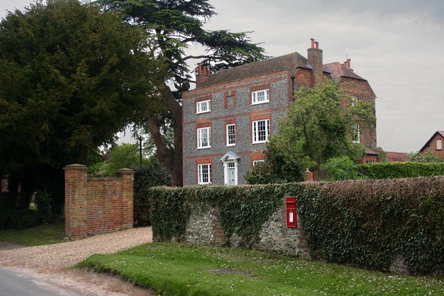
In 1635 the Rectory was described as Handsome & in 1665 was occupied by Thomas Eustace, Gentleman & Rated on 6-Hearths for the Hearth Tax. This House, which has since been replaced, was evidently of a comfortable size; in addition to a number of Offices & Outbuildings, it had a Hall, 2-Parlours & 2-Chambers & a Men’s & a Maid’s Chamber. The Building was divided into 2 after the Eustace Family died out in the early-18thC & was partly a Ruin by 1777. Paul Blackall, the Lessee of the Rectory, Built himself at the end of the 18thC a New Brick & Tiled House, ‘a very comfortable & Modern Erection‘, on the Site of the Old Rectory. It is a 3-Storeyed Building & lies behind a Dwarf Wall with Railings & Gateways, flanked by Red-Brick Piers with moulded Stone Caps. The House was bought by Lord Macclesfield in the late-19thC & from about 1885 until the Livings of Shirburn & Pyrton were United in 1943, the Vicars of Shirburn lived there, facing the Vicars of Pyrton across the Street. It is now used as a Farmhouse.
Pyrton Vicarage is a 17thC House, which was altered in the 18thC when the present South Front of Stucco with Sash Windows & Central Doorway under a projecting Porch were added. The older part of the House is of Lath & Plaster, but Brick has been used in the newer part. The House is separated from the Village Street by 19thC Railings of Cast-iron. When described in 1637 the Vicarage consisted of a Hall, Kitchen, 2-Parlours & Chambers above, but was probably enlarged shortly after, for in 1665 it was Rated at 8-Hearths for the Hearth Tax & came 3rd in size in the Parish after Stonor Park & Pyrton Manor-House. In 1682 it had a Study & 3 more Chambers. Additions were also made in the late-18thC, probably by William Buckle (Vicar 1787–1832), at the cost of £1,000 & by later-19thC Vicars. The existing House is, therefore, a Building of many Dates, composed of Brick, Stone and Lath & Plaster. A Visitor in 1807 described the ‘tasteful adornment‘ of the Pleasure Grounds surrounding the Vicarage & declared the House ‘one of the prettiest Abodes‘.

Vicarage, now a House. Datestone 1788, for Paul Blackall. Header Bond Grey Brick with Red Brick Dressings; M-shaped half-hipped old Tile Roof; Brick end & Rear lateral Stacks. Double-depth Plan. 2-Storeys; symmetrical 3-window Range. Carved brackets to originally Pedimented Doorcase: 4-panelled Door with decorative Overlight. Gauged Brick Flat Arches over Tripartite Sashes, except central Blind Top-Storey window with Keystone. Red Brick flush Storey Bands. Mid-19thC Canted Bay Window to right & two 2-light leaded Casements to Rear. Single-Storey Rear Service Range of Flemish Bond Brick with Gabled old Tile Roof and 4-light Iron Casements with Gothick Heads. Built as “a very comfortable & Modern Erection“, on the Site of the Old Rectory. It Accommodated the Vicars of Shirburn from 1885 to 1943.

Apart from these Gentlemen’s Houses, Court House, once a Farmhouse, is worthy of note. Originally a Timber-framed House of 17thC date, the South Front of 8-Bays has been re-Fronted in Vitreous Brick. The Roof is Hipped & a 17thC Timber-framed Gable remains at the back.
Court House – Early-16thC, remodelled & refaced in early-18thC. Originally Timber-framed; heavy Framing in square panels with Brick Infill to the rear of the Left Wing. Front of Header Bond Grey Brick with Red Brick Dressings; Hipped & Half-hipped old Tile Roof; large Brick Ridge Stack. L-Plan with left Wing. 2-Storeys; 8-Window Range. Segmental Arch over 19thC 6-panelled (2 glazed) Door: 20thC Porch. Segmental Arches over 2-light Leaded Ground-floor Casements, except 1-Blocked Window & 20thC Window to Left; similar 1st-Floor Leaded Casements, except 2-Blind Windows & 20thC Window over Door. Mid-18thC Outshut to Right & 20thC Rear Outshut.
Interior: Chamfered & Stopped Beams, Timber-framed Partitions & Queen-post Roof with Clasped Purlins.

‘The Plough‘ at Pyrton, an Ind Coope Pub in 1976. Pyrton was a small Village with a Population of about a 100 & falling, with an average age of what seemed like a 100. Besides the Pub, the Village had a small Church, which shared its Vicar with several other Parishes. The Pub itself, situated opposite a Farm, was Thatched & consisted of 1-Bar with a Large Inglenook at one end & a Bar Billiard Table at the other.

The Plough Inn was a Public House. Late 17thC, extended to the Right in early-18thC & to Left early-19thC. Left Bay of light Timber-framing: early-18thC colour-washed Chalk Rubble with Brick Dressings to Right. Gabled Thatch Roof; Brick End & Ridge Stacks. 3-Unit Plan. 1-Storey & Attic; 4-Window Range. Segmental Brick Arch over 2-light Casement to Right: flat Brick Arches over a Blocked Door & 1 & 2-light Casements to left; 2-light half-Dormer Casements. Present entry in mid-19thC Brick Bay to right. Early-19thC 2–Storey Bay to Left of colour-washed Flint & Brick, with Gabled Welsh Slate Roof.
Interior: Chamfered & Stopped Beams. 1st-Floor likely to be of Interest.

The Chief 19thC additions to the Village are Shirburn Lodge, Built early in the Century & the School of 1895. The Lodge, the West Lodge of Shirburn Park which lies to the North-east of the Village, is a 2-Storeyed Building in the form of a 8-sided Stucco Tower.
Shirburn Lodge – House. c.1730, for Joseph Collett; enlarged c.1830. Knapped Flint rubble, Brick Quoins & Dressings. Welsh Slate Roof; Brick Stacks. Double-Depth Plan. Early Georgian Style. 2-Storeys & Attic; symmetrical 5-window Range with Central 2-Storey Porch. Keyed round-Arched Doorway to 2-panelled double-leaf Door with decorative Fanlight: 6-panelled Inner Door. Gauged Brick Flat Arches over 6-pane Sashes with thick glazing Bars. Moulded String Course; gauged Brick moulded Cornice beneath Parapet. Hipped Roof with 3 Dormers; symmetrical End Stacks.
Similar Rear Elevation has similar Sashes with surrounds & Flat Hood over Central Doorway. Extension to Right c.1830, of Flemish Bond Brick with a 5-window Front Range of similar Arches over Sashes flanking central Canted Bay & 1st-Floor Sashes: Stone moulded Cornice.
Interior: Panelled Open Hall to Right has 2-Bay Doric Screen & Open-well Staircase with turned Balusters, & Urn Finials to Newel Posts. Panelled Ground & 1st-Floor Rooms with Fireplaces. Early 18thC Fireplace in the Ground-floor Rear left Room: early-18thC Fireplaces & Panelled Dados in rear Left & rear 1st-Floor Rooms. Bolection-moulded Panelling in a tall early-19thC Room to the Right. The House was bought by Lord Macclesfield who used it as a Dower House c.1775.


Clare Hamlet: Once Pyrton’s Largest Hamlet & a Township of 517-acres, now consists of 10-Cottages & 1-Farmhouse. South Farm, or Manor Farm as it used to be called, is in the main an 18thC Building of 2-Storeys with Attics and was approached by an Elm Avenue, but it incorporates part of an Older House, known to have been Leased by Thomas Quatremain in the Reign of James I. Clare lies in a cul-de-sac on the Western edge of the Ridge, some 350-ft up on the Clay near its Junction with the Greensand & where there are a couple of Springs. Its name means ‘Clay Slope‘. Ancient Roads, one to Thame & the other to Henley, intersected nearby. The Hamlet is an example of a Medieval Village, of which the Population shrank in the late-Middle Ages, probably as a result of Plague in the 1st place & Later of Inclosure. There are Banks near the Cuxham–Stoke Talmage Road that perhaps indicate the Sites of earlier Buildings. The Layout of the Ancient Hamlet can be seen in early-18thC Maps: there are 4-Farmhouses, a Bowling Green & Village Green with its Oak or Elm Tree in the Middle. Hedged Closes lie around it & to the South & South-west the remains of the Township’s 3-Open-fields. The most substantial House, depicted by the Cartographer as L-shaped and with 3-Chimneys, was Franklin’s. His Ancestor had been rated on 5-Hearths in 1665. These 4-Farmhouses still comprised the Hamlet in 1811, but in the 19thC increases in Population & changes in Agricultural Practice led to the Building of more Cottages & the use of Farmhouses as Labourers‘ Cottages. North Farm ceased to be a Farmhouse only after 1945.

In 1612 William Webb was Commissioned by Magdalen College to draw an Estate Map of Golder Manor (North is not a vertical Point).It is drawn to an Accurate of Scale with colour representing the Field Systems. Some of the Trees, Hedges & Pastures depicted on the Map are still in evidence. The realisation that a peculiar Hedge Formation, possibly in days past used for penning Sheep & drawn on the Map corresponded in Location to that Found on an OS Map. The Ancient Track on Golder Hill down which the Parliamentary Troops Descended is shown. The Track was still in use until the early-1930s but was Ploughed over & fell into disuse. Also depicted on Webb’s Map is a Thumbnail Sketch of Warpsgrove House. The Legend written under the Sketch reads: ‘Warpsgrove House in Tymes Past a Parish Church’.

Goldor Hamlet: A Medieval Township of 659-acres, now consists of 6-Cottages & the Manor-House. It was never as populated as either Clare or Standhill & is an instance of a Hamlet which was Depopulated before the 17thC & then made some recovery in the 19thC. Various 13thC references to ‘Old Goldor‘ may indicate that the Hamlet suffered some Disaster in the early-Middle Ages & was refounded on another Site, but it is more probable that ‘Old Goldor‘ was actually another Hamlet & was, in fact, Clare itself. At the end of the Middle Ages, Inclosure may have Led to some reduction in Goldor’s Population. In 1738 an Estate Map shows only ‘Goldor Farm‘ to the South & a smaller Farmhouse to the North & by 1811 there were but 2-Cottages & the Manor-House; 2-Cottages were Built in 1812 & 2 more have been Built since. The present Manor-House stands on the Site of a Medieval Moated Homestead & it is approached by a sunken Road, once Lined with Elms, where other Medieval Dwellings probably once Lay. On the North of Golder Manor is a small rectangular Moat enclosing a space now Destitute of Buildings. There appear to be clear indications on Aerial Photographs of abandoned Sites. The Manor-House, a substantial Farmhouse of 2-Storeys dates mainly from the 17thC, but it was modernised in the 18thC & faced with Vitreous Brick with Red Dressings. The Barns & Outbuildings are partly Weather-boarded & partly Built of Brick & Stone. Some of the early-Tenants were men from well known Oxon Families of the Lesser Gentry. Rudolph Warcup was the Lessee in 1640, Francis Duffield, Gentleman, in 1665, when the House was rated on 4-Hearths; & Thomas Tipping in 1688. In Tipping’s Lease Magdalen College stipulated that he was to inhabit the place 4-months Yearly, have an honest Servant there all the year-round & entertain the President, when viewing Repairs, for a Day & a Night.
Standhill Hamlet: Another of Pyrton’s Lowland Hamlets, is a case of an almost completely deserted Site of a Medieval Hamlet: only some Farm Sheds at Upper Standhill & Lower Standhill Farmhouse remain, but traces of old Habitations & the Line of the Hamlet’s Street can be clearly seen on the Ground & in Aerial Photographs. There are records of its 13thC Manor-House where Courts were held & of its Chapel. The Hamlet was prosperous in the early-Middle-Ages but was seriously depopulated by Plague. In 1745 the Chapel was said to have been long used as a Cowshed & was a Ruin. Only a part of the Walls & a small Tower used as a Pigeon Loft were then standing. Delafield, the incumbent of Great Haseley, sketched these & cited White Kennett’s earlier comment that they were in danger of falling into Ruin & ‘being forgot‘. The Chapel’s Site just South of the Farm Sheds at Upper Standhill is marked on Richard Davis’s Map of 1797 & on the Ordnance Survey Map of 1881. Standhill Tithe Map of 1840
Early OS Map of Oxford County
Surveyed by a Local Man, Richard Davis of Lewknor & Published in 1797. This large Map consists of 16-Sheets at an impressively detailed Scale of 1:31,680 or 2in to 1-mile. No more than 200-copies were ever made, the evidence is based on all sets of the Map having Manuscript Serial No.s – this Image is part of No.34. Very few complete Copies survive. In terms of what the Map shows, a clear break has been made from the Christopher Saxton-led traditional County Map, as here far more detail than previously is featured. Not only are County & Hundred Boundaries, Rivers & Streams, Towns & Villages, Parks & Woodland depicted, but here we have Roads, Tracks, Hedges, indeed every Field can be seen & relief is beautifully represented by the use of Hachures. Davis was also Topographer to His Majesty, George III.

Oxfordshire Way Map 36
Pyrton to Christmas Common
Oxfordshire Way Map 37
Christmas Common to Pishill 1 (Christmas Common to Hollandridge Farm)
Reproduced from VCH Oxfordshire, available online at British History Online
