
Newington, a Village in the District of Wallingford & County of Oxford, and a Parish partly also in Henley District, Oxford. The Village stands on the River Thame, 4¾-miles North of Wallingford, and 5¾-miles East of Culham Railway Station. The Parish contains also the Liberty of Berrick-Prior, the Tythings of Brookhampton & Great Holcombe, and the Chapelry of Britwell-Prior; and its Post Town is Wallingford.
Until modern Boundary changes the main part of Newington Parish, located in the Thame Valley c.14Km South-East of Oxford, comprised the 4 Tithings of Newington (Site of the Parish Church), Berrick Prior, Holcombe, & Brookhampton. Each had its own Fields, and was usually Taxed separately. A detached Chapelry at Britwell Prior lay 7 Km to the South-East, its Houses & Fields closely intermixed with those of Britwell Salome parish in Lewknor Hundred, while a detached Woodland area lay on the Chilterns above Watlington. The whole Parish (Holcombe apart) derived from an Estate Granted to Canterbury Cathedral Priory in the 11thC and Ecclesiastically it remained a Peculiar attached to Canterbury Diocese until 1846. Britwell Prior Chapel was served from Newington until its Demolition in 1865, its frequent neglect contributing to the growth of a Roman Catholic Mission in Britwell in the 17th-18thCs.
Newington Parish Tithe Map 1840
Stadhampton Parish Tithe Map 1849
Economically the Parish relied on mixed Farming, with Rural Crafts & Trades concentrated around the Turnpike Road through Brookhampton & Holcombe. Country Houses at Newington & Britwell were built for resident Lords c.1679 and in 1727/8, while piecemeal Inclosure swept away Village Greens & several Cottages at Newington & Berrick Prior in the 17th & early-19thCs. Most fringe Settlements were transferred to other Parishes in the late-19th & 20thCs, leaving only Newington & Holcombe within the modern Civil Parish.

Parish Boundaries
The Parish’s shape was determined by Queen Emma’s Grant of Estates at Newington & Britwell to Canterbury Cathedral Priory between 1017 & 1035, reflecting the fragmentation of Benson’s Royal Estate. The Grant included practically all of the later Parish, and though Holcombe initially remained attached to Benson, its proximity to Newington Church suggests that it was probably absorbed into the emerging Newington Parish at an early date. A further consequence of Emma’s Grant was that Berrick, Britwell, & Holcombe became permanently divided between Newington and adjoining Parishes & Lordships.
The Ancient Parish’s main part was mostly defined by prominent Landscape features, including (on the West) a long section of the River Thame. Boundaries in the South-West, South, & South-East (bordering Warborough, Berrick Salome, & Ewelme) largely followed probable Roman Roads, while the Eastern Boundary with Chalgrove followed a Track & Hedgerow, excluding on the North the Streamside Meadows included within Chalgrove Manor & Parish. The rest of the Northern Boundary followed Chalgrove Brook, which like the River Thame (into which it empties West of Brookhampton) formed part of the Hundred Boundary. In 1881 that main part comprised 2,116a, including 5a of Meadow at Drayton St Leonard. The internal Township Boundaries mainly followed Field divisions, while Holcombe Brook separated Holcombe from Newington.

Britwell Prior Chapelry lay detached, and until the 19thC remained closely intermingled with adjoining Britwell Salome. The 2 shared a Field System which presumably pre-dated the 11thC changes, its individual Strips Titheable to one of the 2-Parishes, while houses, too, lay intermixed. At Inclosure in the 1840s the Boundaries were rationalised, with Britwell Prior defined as 3 separate Parcels encompassing 720a in all. The largest (467a) included the Chapel & Priory Farm and the smallest (77a) Britwell House and its Park, while the 3rd Parcel (175a on the Chilterns at Shambridge) was probably unaltered since the Middle Ages when Woods there belonged to Newington Manor perhaps as part of Emma’s pre-Conquest Grant. The Britwells‘ Western Boundary with Brightwell Baldwin and Northern Boundary with Cuxham were certainly of Anglo-Saxon Origin, being described in Charters of 887 & 995.
From the 19thC, the Parish (2,836-acres in total) was reduced by successive Boundary changes. For Ecclesiastical purposes, Shambridge was transferred to Pishill in 1854, and in 1867 the rest of Britwell Prior was annexed to Britwell Salome. For Civil purposes, Newington lost 5a to Drayton St Leonard in 1882, while Brookhampton (271a) was transferred to Stadhampton in 1932 & Berrick Prior (41a) to Berrick Salome in 1992. Britwell Prior formed an Independent Civil Parish from 1866 to 1912 when it was merged with Britwell Salome, the resulting Britwell Parish losing Shambridge to Watlington in 1932. In 2011 the surviving Civil Parish of Newington covered 1,799a (728 ha).
Landscape
The Parish’s main part occupies gently undulating Farmland, rising from the River Thame (at 50M) to Newbury Hill in the North-East (65M), and to Ewe Farm (82M) in the centre. Berrick Prior, in the South, lies at 57M. Meadows & Pastures along the River & Chalgrove Brook occupy Alluvium accumulated through regular flooding; elsewhere the Parish lies mostly on Gault Clay, giving stiff soil containing Mudstones, while around Ewe Farm and East of Berrick Prior a lighter Loam based on Upper Greensand supported Furze until Inclosure. Springs break out North-East of Berrick Prior at the junction of the Clay & Greensand, flowing into the Hamlet down the narrow Valley of Hollandtide Bottom, which in 887 was called Holandene or ‘Hollow Valley’. A Pond there was formerly used to Dip sheep. Holcombe (also ‘Hollow Valley’) is probably similarly named from the shallow Valley of Holcombe Brook, a short Stream which rises North of Ewe Farm and empties into the River Thame North of Newington. A Pump beside it supplied Newington & Holcombe residents until the arrival of Piped Water in the early 1950s. Woodland is scarce, concentrated in coverts planted in the 19th & 20thCs.
Britwell Prior’s Landscape is markedly different, formed almost entirely from chalk, and rising steeply from the edge of the Oxford Vale in the North (110M) to the high Chilterns (230M) in the South, where Ancient Woods at Shambridge (‘Sandy Ridge’) occupy Hilltops capped with Clay-with-Flints. Britwell House stands at 140M on a Hillock composed of Clay, Sand, & Gravel. Surface water is largely absent except around the Chapel Site, where a Spring at the junction of the Chalk & Clay gave rise to Britwell’s place name. A Pond there was preserved as a common Watering-place at Inclosure. The detached Chiltern Woods apart, Britwell Priors light & well-drained soils traditionally supported Arable & sheep Pasture, with just a few small pockets of Meadow near the Spring.
Communications – Roads & Bridges
The Principal Route through the Parish’s main part, passing through Brookhampton, Holcombe, & Newington, formed part of the Road from Aylesbury (Bucks) to Shillingford, Turnpiked in 1770 & de-Turnpiked in 1875. A Tollhouse with Tollgates stood at Brookhampton. The section South of Holcombe was called ‘Wallingford Way‘ in 1490 and part of the Route was Mapped in 1595, when a Bridge crossed Holcombe Brook and a Gate spanned the Road close to Newington Manor House.
Map of the County of Oxford, from Actual Survey, by Andrew Bryant, in the year 1823. Inscribed by permission to the Right Honourable the Earl of Macclesfield, Lord Lieutenant, and to the Nobility, Clergy & Gentry of the County. (Click Zoom Button to enlarge)
![Photograph of Newington House in Newington, Oxfordshire [c 1930s-1980s] by John Piper 1903-1992](https://astonrowant.files.wordpress.com/2019/02/newingtonmanorhsebw.jpg)
Numerous Branch Roads were recorded early on. At Lane End (perhaps the ‘King’s Lane End‘ of 1490), the Branch to Berrick follows a sharp right-angled turn, which in 1595 formed a T-Junction with a continuation of the North-South Road along the Parish Boundary, running towards Warborough. ‘Ascott Way‘, mentioned in the early 14thC when the Lord of Holcombe narrowed it, may have been a Branch Road further North, leading from Holcombe to Ascott in Great Milton, and called a ‘Pack & Prime Way‘ in 1621 and (possibly) ‘Sile Lane‘ in 1694. If so it was lost by 1826. Another Branch from Holcombe, called ‘Coll Waye‘ in 1595, formerly continued Eastwards past Little Holcombe to intersect with Routes to Chalgrove & Ewelme and was subject to protracted Litigation from the 1970s. Westward Routes included the Oxford Road from Brookhampton over Chiselhampton Bridge, the subject of a Legacy by a Rector of Newington in 1425, while a predecessor of Hayward Bridge, on the Road to Drayton St Leonard, was recorded in 1490 and succeeded by the present Road Bridge in 1884. The Berrick-Chalgrove Road is presumably also Medieval.

Several of those Routes were apparently derived from Roman Roads. The former Turnpike South of Holcombe may partly follow the Roman Road from Dorchester to Fleet Marston (Bucks), which further North may have coincided with the lost ‘Ascott Way‘. Alternatively, the Roman Road may have Forded the River Thame at Hayward Bridge, passing South-east of Brookhampton up to Little Milton. Further south, the Romanised Lower Icknield Way ran probably along Hollandtide Bottom and through Berrick Prior, forming part of the Parish Boundary, while at Ladybrook Copse it crossed another probable Roman Route, partly preserved in the line of Hale Lane. In the South-East, the straight North-South lane past Lonesome Farm to Ewelme was apparently called ‘le Stretewey‘ & ‘Akmanstrete‘ in 1490, suggesting Roman Origins, and similarly formed a stretch of the Parish Boundary. Britwell Prior Chapelry was crossed by the main Icknield Way, which follows the Chiltern Scarp, while the Benson-Watlington Road through both Britwells is probably also Ancient. Turner’s Green Lane in Britwell Prior was called a ‘Fielden Way‘ in 995.
Carriers & Post
Brookhampton had a Carrier in 1835, and in 1847 John & William Payne ran regular Services from there to London, Oxford, Eynsham, Witney & Burford. The London Service continued until c.1890 when the Holcombe Beer Retailer and (later) Grocer Thomas Moores started Carrying to Abingdon & Oxford, and another Carrier passed through on his way to Wallingford & Oxford. The Moores Family’s Service continued until the 1920s. Britwell Prior was served in 1854 by a Watlington Carrier, who stopped there weekly on his way to Wallingford. A weekly Bus from Stadhampton to Wallingford was introduced in the 1940s but later withdrawn.
Most Mails came through Wallingford, and a Post Office established in Brookhampton by 1881 was a Money-Order & Telegraph Office by 1883. It moved to Stadhampton in the early 20thC, but returned to Brookhampton after WW2 and remained open in 2014. Britwell Priors letters were delivered through Watlington in the early 19thC, and by 1881 there was a Post Office in Britwell Salome. A Shop at Berrick Prior included a Post Office from the 1960s to 1980s.
Population
In 1086 Newington Manor had 39 recorded Tenants at Newington, Brookhampton, Berrick Prior, & Britwell Prior, with Tenants at Holcombe presumably recorded under Benson. Sixty-four Tenants were recorded on the Manor c.1200 (25 in Britwell Prior, 22 in Berrick Prior, 11 in Brookhampton, & 6 in Newington), while respective numbers in 1279 were 15, 21, 14, and 15, a total of 65. Another 11 lived at Holcombe alongside the resident Lord. Taxpayers in 1327 included 12-people in Britwell Prior, 10 in Brookhampton, 9 each in Holcombe & Newington, and 33 in Berrick (probably including Berrick Salome), placing the Parish as a whole amongst the most populous in the Hundred. The Black Death reduced population particularly at Britwell Prior, where only 4-people aged over 14 paid Poll Tax in 1377 compared with 47 in Berrick Prior, 43 in Newington, 31 in Holcombe, and 21 in Brookhampton. The Parish total of 146 suggests an actual Population approaching 400.
The 1524 Subsidy was paid by 28-Heads of Household, and Parish Registers (extant from 1572) suggest a growing Population. Thirty-five Houses were assessed for Hearth Tax in 1662: 18 in Berrick Prior, 7 in Holcombe, 5 in Brookhampton, 3 in Britwell Prior, and only 2 in Newington, where several Cottages had been lost through Inclosure. Britwell Prior was said to contain 6-Houses in 1685, and the number in the Parish as a whole was estimated at 55 in 1758. Total Population grew from 247 in 33 occupied Houses in 1801 to 471 in 94-Houses in 1841, including 52 (occupying 10-Houses) at Britwell Prior. Thereafter the Population generally declined until the 1920s, when Britwell Priors figures were amalgamated with Britwell Salome’s and 229 people occupied 57-Houses in the rest of Newington Civil Parish. Following a modest increase to 244 by 1931, subsequent Boundary changes reduced the Population to 129 (in 38-Houses) by 1951, and to 104 (42-Houses) by 2001. In 2011 Newington, Holcombe, and outlying Farms accommodated 102 Inhabitants.
Settlement
Prehistoric to Anglo-Saxon Settlement
Despite abundant Prehistoric & Roman Archaeology in neighbouring Parishes, evidence for early occupation in Newington Parish is scarce. A few sherds of late Bronze-Age or early Iron-Age Pottery and some worked Flints have been found South-East of Newington, and a sunken-floored structure near Ewe Farm, containing a Stone-lined Hearth associated with significant quantities of late Bronze-Age Pottery, has been tentatively interpreted as a Craft or Industrial Building. Structural evidence for Roman Settlement is so far lacking, although the discovery of unabraded sherds of 2nd or 3rdC Pottery near Newington House suggests that habitation was close by. Several Roman metal objects (mostly Coins) have been found in the Fields between Newington & Berrick Prior.
Anglo-Saxon Settlements were Sited close to reliable Water supplies. Like neighbouring Brightwell Baldwin, Britwell grew up around its eponymous Spring, while Brookhampton (‘Home Farm by the Brook’) takes its name from the adjacent Chalgrove Brook, & Holcombe from the Valley of the Holcombe Brook. Berrick also developed near Springs, its place name betraying its origins as an outlying dependency (or Berewic) of the Benson Royal Estate. An unlocated Medieval Field-name preserved the memory of a separate Anglo-Saxon Royal Farm or Worth nearby. Further North at Holcombe, a Medieval Grange Granted to Osney Abbey was referred to in 1270 as ‘Kyngesbur‘ (King’s Burh), and possibly originated as an Anglo-Saxon Royal Residence associated with Benson. From c.1300 it was more commonly called Newbury (New Burh), perhaps reflecting Osney’s ‘new’ Ownership or rebuilding of it after c.1155.
The early 11thC Grant to Canterbury Cathedral Priory caused Britwell & Berrick to be each divided into 2-Settlements, the parts belonging to the Priory acquiring the place-name suffix ‘Prior‘ during the later Middle Ages. Then or possibly earlier Holcombe was similarly split, a part (called Little Holcombe in 1241) passing to the Bishop of Lincoln and to Drayton St Leonard Parish. Newington (‘New Settlement’), situated between the 2-Holcombes (Gt & Lt), may reflect reorganisation when the Priory Estate was created, marking the location chosen for the new Church & Manor House.

Medieval & Later Development
Settlement after the Norman Conquest remained focused on the 5-Main Hamlets, with just a few outlying dwellings. Newington bears signs of Medieval Planning, its North-South row of 3 regular compounds between the Village Street and the River Thame containing the former Rectory House, the Parish Church, & the Manor House. Peasant Housing stood a short distance South-East: a Medieval Smithy has been excavated there, and a 1595 Map shows up to 10-Cottages arranged either side of the Street and on the edge of a small Green. The Green itself (still there in 1648 with at least 2-Dwellings) had been Inclosed by 1767, with the loss of most if not all of Newington’s Cottages, since only the Rectory & Manor House were assessed for Hearth Tax in the 1660s. Additional Houses were the outlying Ewe Farm (so-called in 1722 and possibly established by 1595), Lane End (formerly West Field) Farm, of probable 17thC Origin, and a Cottage North of Lane End, erected on Manorial Waste soon after 1795 but Demolished in the early 20thC Later building was small-scale. Hares Leap (formerly Starveall) was built c.1840 as outlying Labourers’ Accommodation for Ewe Farm, & 2 semi-detached Cottages near Newington House were built in the 1930s for Domestic Staff. Four Council Houses known as The Lydes were completed in 1949.

Berrick Prior was arranged until early 19thC inclosure around a large irregular Green at the convergence of 5 Lanes: the surname ‘at Green was recorded in 1306, and in 1270 there was a Chapel. Three or 4 surviving Cottages are partly 17thC, and the Chequers Pub was Licensed by 1754, its Red & Grey Brickwork perhaps inspiring its name. Manor Farm, ostensibly 18thC, was formerly Berrick Farm, and though belonging to Newington Manor until 1856 acquired its modern name only c.1860. By 1805 an adjoining Close was called Burnthouse, presumably recalling a Dwelling destroyed by Fire. Following the Green’s Inclosure in 1815 several Houses on its Northern & Western edges were cleared, the overall number of dwellings falling from 32 in 1811 to 26 in 1821, & to 23 by 1895. The outlying Lonesome Farm was built c.1840 to house a Labourer (in 1861 a Shepherd) on Berrick Farm, while a Cottage and sometime Smithy on the Lane to Newington (Demolished in the mid 20thC) existed by 1812. Within the Hamlet new Bungalows were constructed in the 1960s, followed by further infilling.
Holcombe developed around the junction of the Brookhampton-Newington Road and a lane to Chalgrove & Ewelme. Known as ‘Up Holcombe‘ by the 13thC, presumably to distinguish it from Holcombe in Drayton St Leonard, in the 19thC it was also called Great Holcombe, in opposition to Little Holcombe Farm c.1Km South-East. A D-shaped enclosure contained the Manor House (now Great Holcombe Farm), probably with Medieval Peasant Housing grouped around, while the outlying Hill & Little Holcombe Farms probably originated as Medieval Freeholds, perhaps respectively those known as Newbury (a Grange of Osney Abbey) & Skirmots. Inhabitants ‘of Newbury Hill‘ were recorded in the 17thC, some of them possibly living at Hill Farmhouse which, in its present form, dates from c.1600. Some surviving Cottages are 17thC, and in 1821 there were 22-Houses in the Township; small-scale infilling followed throughout the 20thC, including 3-Houses built in a former Orchard in 1986. An isolated Gamekeepers Cottage mapped in 1826 was Demolished after 1922 & Little Holcombe Farm (with its large Timber-framed Barn) in the 1960s.
Brookhampton adjoins Stadhampton to the North but originated as a distinct Settlement South of Chalgrove Brook, focused on an important Road Junction. In 1270 it had a Chapel. The demolished Brookhampton Farm, as a Copyhold of Newington Manor, presumably occupied an Ancient Site, while surviving Buildings include the Bear & Ragged Staff Pub (of 17thC date & Licensed by 1754) and the former Tollhouse (c.1770).
Bear & Ragged Staff. 17thC remodelled 19thC Coursed Limestone rubble with squared Quoins and some Brick Dressings; old plain-tile Roof with Brick Gable Stack. 2-Unit Plan, extended. 2-Storeys. 2-window Front has plank door with Brick Bay window to right, 3-light casement to left & 2 similar casements at 1st-Floor, all with segmental arches and 19thC Bull-nosed Brick dressings. Small window immediately to the left of the Door in blocked former Entrance. The Roof has Stack to right. Lower 19thC Brick Extension to right has further Entrance and sash over a Basement Entrance. Left end wall & rear of main Range are roughcast with narrow rear casements. Brick Extension projects to rear with Catslide Slate Roof.
Interior: stop-chamfered beams; large central Stack with back-to-back open Fireplaces and flanking Stair. Formerly a Lobby-entry Plan.

The former Turnpike Tollhouse at Brookhampton in the earlier 20thC (looking East), with H E Upstone’s Stores to the Left, and a former Clothing Factory (closed 1901) to the Right, fronting the Newington Road.
In 1821 the Hamlet comprised 16-Dwellings, rising to 25 in 1841, of which 5 stood on Manorial Waste. A Cottage opposite the Tollhouse was demolished c.1860 and 2 on the Chiselhampton Road shortly after 1938; some of their occupants moved into new Houses along the Newington Road and in a cul-de-sac named Warren Hill, where Nissen Huts inhabited during WW2 were succeeded by Houses & Bungalows. A Bungalow Farmhouse (Newell’s Farm) was erected in 1955, and the Grocers Shop was rebuilt c.1960 following a fire. Brookhampton (or Taylors) Farm, a double-pile Farmhouse probably rebuilt c.1800, was replaced in the late 1970s by a small Housing Development called Brookhampton Close, by then in Stadhampton Parish.
Settlement in Britwell Prior was mainly focused around the Spring, which divided Britwell Salome Parish Church from Britwell Prior Chapel (Demolished in 1865). In 1685 the Rector of Britwell Salome described the 2 buildings as standing ‘not above a bow’s shoot from one another‘; Britwell Prior then comprised 6-Houses ‘in the very midst‘ of Britwell Salome, 2o of them West of Britwell Salome Village. Presumably, those represented Plots Granted to Canterbury Cathedral Priory, and intermingling persisted later when Britwell House (built on Farmland in 1727/8) and 2 or 3-Cottages were separated from the rest of Britwell Prior by part of Britwell Salome. Priory Farm, immediately West of the Chapel, probably occupies the Site of Canterbury Cathedral’s Medieval Demesne Farmstead, while to the East a short-lived Castle may have been erected during the Civil Wars of the 1150s. William of the Castle (de Castello) was mentioned c.1200, and by the early 18thC the Chapel was sometimes called ‘Castle Church‘, and the Hillock on which it stood ‘Castle Hill‘. A Church House mentioned in 1618 probably stood close by. The present Priory (formerly Upper) Farm dates in part from c.1600, and Cooper’s (formerly Lower) Farm, recorded from 1717, was rebuilt in Brick in the mid-18thC. In 1821 the Chapelry contained 7-Dwellings and in the 1880s Britwell House gained a Park Lodge and a Gardener’s Cottage. 20thC Building was confined to renovations & extensions of existing dwellings.
Britwell Prior Tithe Map 1845
A few additional Dwellings existed in the Chapelry’s detached Upland part at Shambridge. The Surname ‘of Shambridge‘ (de Samerugge) was recorded in the 13thC and Henry Piddington lived there in the 1630s. Two Cottages were erected in the 1850s, and in 1901 Shambridge’s population totalled 6-people.

The Built Character
Only 2-Domestic buildings are known to retain Medieval work: Great Holcombe Farm, a former Manor House with a 15thC core & Beauforest House (the former Rectory), which dates partly from c.1500. Manor House (near the Church) may preserve part of Owen Oglethorpe’s Manor House, built or rebuilt using Headington Stone c.1578. In the 1660s Newington’s Manor & Rectory Houses were the largest in the Parish, with 12 & 10-Hearths respectively; most other Houses had 1 or 2-Hearths, 5 had 3, & 3 (almost certainly including Great Holcombe Farm) had 4, indicating (together with Probate evidence) the presence of a few substantial Yeoman Farmhouses. One is Priory Farm in Britwell Prior, in origin an L-shaped Timber-framed & Thatched Farmhouse of c.1600 with 2-Storeys & Attics, and a massive central Brick Chimneystack. In 1619 its Rooms included a Parlour, Hall, Kitchen, Buttery, 4-Chambers & 2-Lofts and in 1684 there was a ‘new Chamber’, while in 1662 it was assessed on 5-Hearths. Other 17thC examples include Hill Farm in Holcombe (Timber-framed with an L-Plan & Lobby Entry), The Innocents in Berrick Prior (Limestone rubble & Thatched with Mullioned windows and a Central stair), and the Bear & Ragged Staff Pub in Brookhampton (also of Limestone rubble, originally with a Lobby Entry).
Innocents House. Mid-17thC, extended 20thC. Colourwashed Limestone rubble; Thatch Roof with Brick Gable Stacks. 2-Unit Central-Stair Plan, extended to rear. 2-Storeys plus Attic. 3-window Front has a wide heavy-framed Entrance, to the right of centre, below a small 2-light Stone-mullioned window with Label; to left are 4-light Mullioned windows and there are 3-light windows to right, all with Labels & leaded lights. The Roof has a small eyebrow Dormer to right, probably 20thC, and there are further Dormers & Mullioned windows at the Rear. There is an added 2-Storey Rear Wing & a small lean-to extension to right.
Interior: Timber-framed Partitions flank Central Bay with quarter-turn Stair rising to Attics. 2 ovolo-moulded Beams; open Fireplace with ogee chamfer-stops to bressumer; Brick Fireplace with shallow chamfered-arch in chamfered rectangular recess and a Bread-oven; 2 x 1st-Floor Fireplaces with cambered bressumers; old plank & panelled doors. Roof has 2-rows of straight Windbraces, and Purlins are clasped over Partitions but abut intermediate Braced-collar Trusses.

Lowlier 17thC Buildings include Farthynge Cottage in Holcombe (Timber-framed & Thatched with a Lobby-entry Plan), Priory Cottage in Berrick Prior (Limestone rubble & Thatched), and Thatched Cottage in Berrick Prior (Timber-framed & Thatched). Similar Cottages (Thatched with a mixture of Timber framing, Brick infill, & Limestone rubble) formerly existed in Brookhampton and others may have once surrounded Berrick Prior’s Green. Several Cottages & Farmhouses were remodelled in the 18thC, including Hill Farm (which was extended and refaced in stone), and Great Holcombe Farm (where the Timber-framed Walls were encased in Stone Rubble and the Building enlarged to provide a double-pile plan).

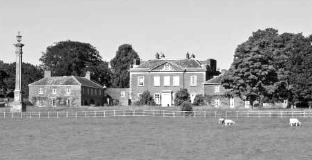
Classical Architecture arrived c.1679 with the construction of Newington House, a 7-Bay Mansion of 3-Storeys over a Basement built probably for Henry Dunch. Equally ambitious was Britwell House, a compact Palladian Mansion built probably by William Townesend for Sir Edward Simeon in 1727/8. Both were remodelled in the late 18thC. More modest Houses with neo-Classical features appeared after 1700, amongst them Priest’s House in Britwell Prior (Flemish-bond Red & Grey Brick), the former Parsonage in Newington (largely rebuilt in 1796), and Garden House in Britwell Prior, like Ewe Farm (in Newington) a late Georgian Brick-built house with Hipped Roofs. Priory Farm’s remodelling in 1826 was almost certainly commissioned by the Lord of Britwell Salome, Richard Newton, its L-Plan being converted into a Square, and its principal Entrance moved from the East to the South Front, which took on a Classical symmetry with Brick walls, Sash windows, and a Hipped Slate Roof. In 1837 its Farmyard (to the West) gained a Weatherboarded & Tiled Barn.
Victorian Buildings comprise a few Brick & Tile Cottages (some of those in Holcombe bearing Datestones), and Newington’s Red-brick former School of 1857. From the 1930s new housing was erected along the Newington Road in Brookhampton, and further Building after WW2 included 4-concrete-built Council Houses in Newington (refaced in Brick in 1999), a few Brick Houses by the Local Builder Cecil Howlett, constructed from the early 1940s, and numerous Bungalows erected from the 1950s, some of them subsequently replaced with Houses. Priory & Cooper’s Farms in Britwell Prior were extended for the Farmer Richard Roadnight in 1958, while Britwell House & Newington House were both renovated in the later 20thC, the former (in the 1960s) by the Designer David Hicks. Hicks also restored several Estate Cottages.
OS Map 1918 Sth Oxon XLVI.7 (Newington)
