Lewknor Village started as a Saxon Spring Line Settlement near the foot of the Chilterns Chalk Escarpment. The name is derived from the Old English name of its owner Leofeca and refers to a flat-topped Ridge with a Convex Shoulder, presumably Beacon Hill, which would have been a Landmark for those Travelling on the Icknield Way. The earliest reference of the name is in the records of a Lawsuit in AD-990. In the 11thC the Manor of Luvechenora was held by Edith of Wessex, who in 1045 became Queen Consort of Edward the Confessor. The Manor then passed to a Danish Thegn of King Edward called Tovi, who bequeathed it to Abingdon Abbey. For most of the Middle-Ages the Abbey Leased out Lewknor Manor, until the Abbey was Suppressed in 1538 in the Dissolution of the Monasteries. The Church was Bestowed on All Souls College, Oxford in 1440, the College subsequently acquiring further Land in the Parish and remaining a Major Landowner to this day.
In the 19thC Lacemaking was a significant Industry in the Area with 45–Lacemakers in Lewknor while some 12-People made Components for the Chair-making Industry.

The Parish lies in the South-west of the Hundred which bears its name. Like other Parishes that run up into the Chilterns, Lewknor forms a long narrow strip, 2-miles broad at its widest and 5-miles in length from North-west to South-east. In 1959 it contained 2-Divisions or Townships, covering 2,692-acres and named respectively Lewknor & Postcombe. The 2nd of these was a Hamlet called ‘Postelcumbe‘ in 1279. Up in the Chilterns some 2,000-acres once formed 3-Detached portions of Lewknor Parish and together constituted the Division of Lewknor Uphill, but in 1844 they were relinquished to Bucks. They now belong to other Parishes: Studdridge, with a portion of Wormsley, has been joined to Stokenchurch; Cadmore End was made in 1852 into a separate Parish; Moor End or Ackhampstead, which was once an outlying Chapelry, was added in 1885 to Great Marlow.
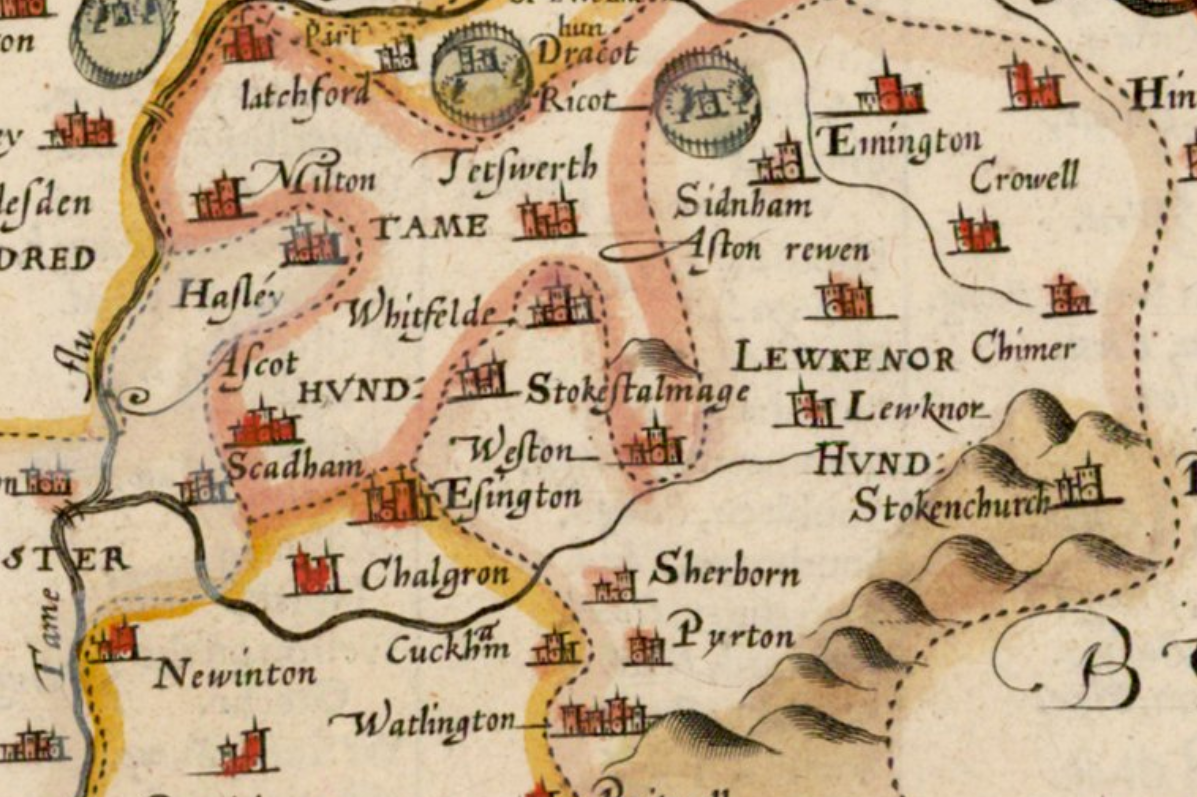
OS Map of Oxford County: Surveyed by a Local Man, Richard Davis of Lewknor & Published in 1797. This Large Map consists of 16-Sheets at an impressively detailed Scale of 1:31,680 or 2-ins to 1-mile. No more than 200-Copies were ever made, evidence being based on all Sets of the Map having Manuscript Serial No.s – this Image is part of No.34. Very few complete Copies Survive. In terms of what the Map shows, a clear break has been made from the Christopher Saxton-led traditional County Map, as here far more detail than previously is featured. Not only are County & Hundred Boundaries, Rivers & Streams, Towns & Villages, Parks & Woodland depicted, but here we have Roads, Tracks, Hedges, indeed every Field can be seen, and relief is beautifully represented by the use of Hachures. Davis was also Topographer to His Majesty, George III.
Ackhampstead (literally ‘Oak Homestead‘ in Old English) or ‘The Moor‘ was an Ancient Township (or Chapelry) in the Chiltern Hills, South of Lane End. Until 1844 it was a detached part of Oxon in the Parish of Lewknor, part of a Division of the Parish known as Lewknor Uphill consisting of 3-detached parts. It was transferred to Bucks by the Counties (Detached Parts) Act 1844. By the mid-19thC, the Population of the Community was negligible. The Bishop of Oxford Demolished its Medieval Chapel and replaced it with a new Church at Cadmore End. In 1885 the division of Lewknor Uphill was dismembered. Ackhampstead was transferred to the Parish of Great Marlow for Ecclesiastical purposes and became part of the Civil Parish of Great Marlow in 1895. In 1934 the Western end, including Moor Farm, became part of the Civil Parish of Fingest, renamed Fingest & Lane End in 1937, and is now in Lane End Parish. The greater part, including the Site of the Chapel & Moor Wood, remains in Great Marlow Parish. A detailed History of Ackhampstead was compiled by Dr Gordon Wyatt in 1969 for the Frieth Village Society.
Lewknor-Uphill Tithe Map Index
Lewknor-Uphill Tithe Map c.1840 in 3 Parts
The Ancient Lewknor Parish was quite 10-miles Long and was said to be at least 40-miles in Circumference. In 1733 the Vicar, Thomas Skeeler, reported to the Lord of the Manor that after ‘much Persuasion and a Sermon‘ he had prevailed at last upon the Parishioners to make the Perambulation of the Circuit of the Parish ‘nowadays called possessioning – It is betwixt 40 and 50 years since we have had anything of this kind.’
The Geology of the Parish is varied. The most Productive part lies below the 500ft contour line, at the foot of the Chiltern Hills, for here the Chalk subsoil is covered by a rich fine Loam, productive of good Crops, though a Vicar wrote in 1707 that a great deal of the Land under the Hills was not worth the Ploughing in Dry years. Part of the Land is on the Flint covered Chalk Hills from which Lewknor has derived its name, ‘Leofecanora’ or Leofeca’s Slope, for that was the form of the name about the year 990. The highest point (837-ft) is on the Summit of Beacon Hill (a name that perpetuates the Memory of Elizabethan Watch & Ward), and the Land then drops down again for some 250-ft through Beechwoods towards Stokenchurch.
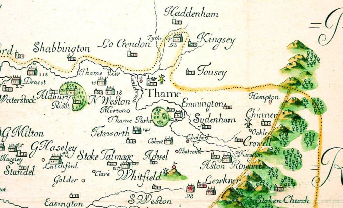
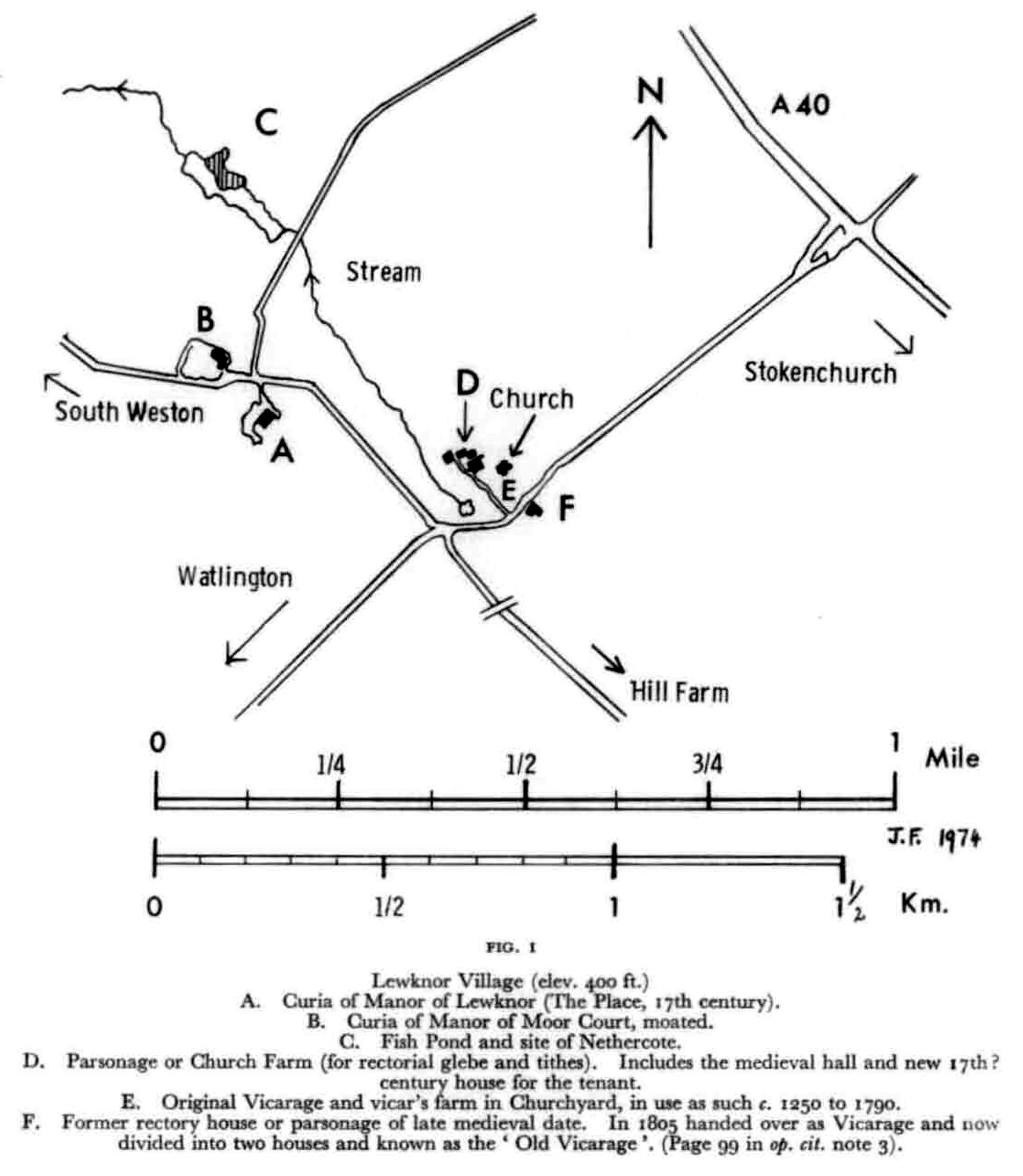
At least 2–pre-Roman Roads cross the Parish from North-east to South-west. The Chiltern Ridgeway keeps to the top of the Ridge and is still in use in this part of its course. The Icknield Way runs along the foot of the Steep Escarpment, keeping approximately to the 500-ft Contour, and formed, in early times, an alternative to the Ridgeway for use in Summer. Roads that connect Lewknor with Aston Rowant & Chinnor to the North-east, and with Shirburn & Watlington to the South-west, keep close to the 400-ft Contour and in Medieval Times were known respectively as Aston Way & Watlington Way. Beyond them, to the North-west, a Road leads from the present London & Oxford Road to Moor Court Farm and once continued beyond it towards Shirburn. It is now called Nethercote Lane and was earlier known as the Lower Icknield Way, and earlier still & more correctly as Hackman Way.
Map of the County of Oxford, from Actual Survey, by Andrew Bryant, in the year 1823. Inscribed by permission to the Right Honourable the Earl of Macclesfield, Lord Lieutenant, and to the Nobility, Clergy & Gentry of the County. (Click Zoom Button to enlarge)
Other Roads run from North-west to South-east. Those from Oxford & from Thame converge at the Hamlet of Postcombe to form the London Road. North of Postcombe the Road from Oxford forms part of the West Boundary of Lewknor, dividing it from Adwell. After crossing Nethercote Lane and until it gets to the Icknield Way, the Oxford-London Road (A40) constitutes the North-eastern Boundary of the Parish. Upon reaching the Chiltern Slope at the foot of Stokenchurch Hill, the Boundary falls a Stone’s throw behind the present Roadway and, continuing Uphill along a cutting, appears to perpetuate the original line of Ascent. About ¾-mile to the West of the London Main Road, a Lesser Road, once named Weston Woodway, comes in from South Weston near the Moated Farmhouse of Moor Court and reaches Lewknor at the West end of the Village. Beyond that point, it continued, as Sheepcote Lane, to the Icknield Way, where it falls into a Hollow Way, called Clay Lane, which leads up the Slope, past some old Chalk Workings, to the Ridgeway. Midway between them and the Icknield Way ran the Watlington Branch of the former GWR Line Built in 1872.
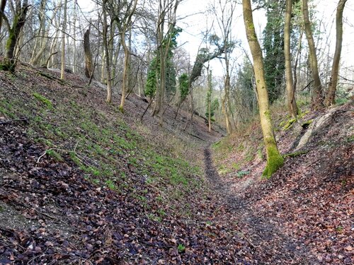
Lewknor Bridge Railway Halt: The Halt was one of 3 that the GWR opened on the Princes Risborough/Watlington Line in September 1906 to try to encourage Passenger Traffic in the face of increased competition from Buses. It was Southeast of Lewknor, on the Western side of a Bridge carrying the Railway over a Lane known as “Shiftcutts“. The Bridge (No.6m74c), which had 19-ins (480mm) Wrought Iron Girders, spanned 20-ft (6.1M) and was supported by Brick & Flint Abutments; it had a minimum Headroom of 15ft-8ins (4.78M). A Single Platform was provided on which stood a Wooden Passenger Waiting Shelter and the Running-in board – a large Sign showing the name of the Railway Station. The Halt was unstaffed and in Winter 2-Hurricane Lamps lit the Platform at Night, both being Lit & Extinguished by the late-turn Guard. Access to the Station was via a Kissing-gate and a Flight of Steps from the Roadside on the Southside of the Bridge. In the longer term the GWR’s Halt strategy did little to dissuade people from more convenient Bus Services. In 1957 British Railways closed the Halt and withdrew Passenger Services from the Line. Shiftcutts (now known as Hill Road) was truncated by the Building of the B4009 Watlington Road which bypasses Lewknor Village, cutting across the former Railway Alignment and obliterating the Site of Lewknor Bridge Halt. Although the Bridge no longer exists, the Steps leading up to the Halt are still Extant.
OS Map 1919 – Oxfordshire XLVII.7 ( Lewknor)
About ½-mile below the Icknield Way where the Chalk begins to give way to the Greensand lies Lewknor Village. A Spring of Water fills a Quarrylike Depression known in 1716 as the Town-Pond and once a Water-cress Bed; and hence a Stream Flows through Lewknor Green to South Weston, eventually joining the River Thame. To the East of the Pond stands the Church, and at one time a Vicar’s House stood on the Southside. The ‘old Vicarage‘, now divided into 2-Houses, is on the opposite side of the Road and was formerly the Parsonage or Rector’s Manse. Cottages Line 4-Crossroads, and somewhere in the Centre of the Village was the Common Pound. There is no sign or record of a Village Cross, but the neighbouring Hamlet of Postcombe had both Pound & an Ancient Cross which was known in 1348 as Postelcombe Crouch.
15thC Leases & Bills for Repairs show that the Parsonage, which must then have been the Principal Building in the Village after the Manor House, had a Hall of Medieval Pattern with a Louvre for its Central Hearth. The Kitchen was a separate Building, and within it was a Well. Adjoining it were the various Buildings of the Steading: the Great Barn which was the Rector’s Tithe-Barn, a smaller Barn or Hay-house, a Stable, Sheep-house & Hog-stye; likewise a Brew-house, Malt-house & Kiln. Their Roofs were Thatched; they stood on Base Courses of Headington Stone, and their Walls were Wattle & Daub. A Lease of 1507 provides that the Tenant shall Repair ‘all mudde and dawbyd wallys home hye‘, meaning as high as Cattle could reach with their Horns. No part of the present Building is earlier than the 17thC. The older part was Built of Flint & Brick, the later part of Brick only. It was described in a Terrier of 1736 as a good Mansion-house with a Brew-house & Court adjoining to it; a large Yard with a Pigeon-house standing in it; 2-Large Barns with a Stable, Cow-house & Cart-house, 2-little Gardens, 2-Orchards & 2-Acres of Arable enclosed, adjoining to the Upper Orchard’. A Storey was added to the front part of the Building in the 19thC.
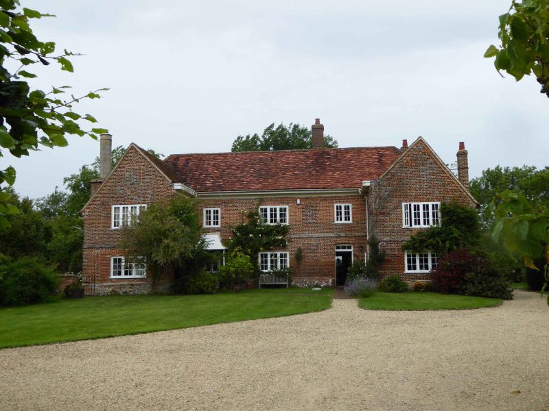
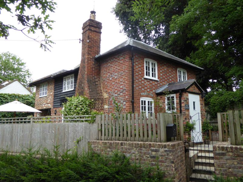
Nearby Moor Court survives as a Farmhouse, H–shaped in Plan, standing within a Medieval Moat. Two-Storeyed with a Tiled Roof, it was re-Built in the 18thC of Chequer Brick with Flint Dressings. At one end of the House are the remains of a Tudor Chimney-stack, and some Timber-framing. 19thC Casements have replaced earlier windows.
Moor Court -Farmhouse, Weston Road, Lewknor. Late-17thC, probably with earlier Origins. Random Bond Brick; Flemish Bond Brick with flared Headers to front of left Wing & Rear; Side Wings partly refaced in early 19thC Brick. Gabled old Tile Roof; left end Brick Stack with Stone Quoins & rebuilt Octagonal Flue; Brick Right end & Internal Stacks. H-plan. 2-Storeys; 5-window Range. 1:3:1 fenestration of Central Hall & Flanking Wings. Flat Brick Arch over mid-19thC 4-panelled (2 glazed) Door with mid-19thC Cast-iron Porch, left of Centre; segmental Arch over Plank Door with Overlight to right of Centre. Flat Brick Arches over 20thC Casements; blocked segmental-arched windows. Raised Storey Band. Rear left Gable has exposed Queen-Post Truss. 20thC rear Outshut.
Interior: cased Beams; full set of chamfered & stopped Beams to rear left. Quarter-turn Stairs to Rear right. Right Wing has ribbed Door & 3-Bay Queen-post Roof with Clasped Purlins. 19thC Plaster Hides much likely to be of interest. Moor Court lies within an early-Medieval Moated Enclosure.
Postcombe, too, had its Inn, the ‘The Bunch of ‘Feathers‘, so-called at least from 1734 (now post The Feathers – renamed ‘England’s Rose‘); it was a smaller place than Lewknor, having but 10-Houses Listed for the Hearth Tax of 1662 when Lewknor had 43 (more specifically described a Century later as 7-Farmhouses & 38-Cottages), and some of these were in Adwell Parish. But it was growing during the 17thC and 2 of its Brick-Built Farmhouses, Adwell & Poplar Farms, belong in part to that Period. By 1768 there were 5-Farmhouses & 18-Cottages at Postcombe. During the next 100-yrs, Postcombe & Lewknor nearly doubled their size, for in 1861 their Houses numbered 127. By 1901 the figure had dropped to 102. Many well-Built Cottages & small Houses were put up during this Period: they are mostly of Flint with Red Brick facings; some belonged to the Squire and are marked with the letters ‘J’ for Jodrell & ‘W’ for White. A Row of Houses was Built on the Old Watlington Road end by a Local Builder about 1911, 8-Council Houses were erected after WW1 & 12, constructed of Grey Concrete, after WW2 (now Demolished). The Bullingdon RDC in 1958 brought Mains Water to the Village, which hitherto has mainly had to depend on Well Water, though some Houses were Supplied from Watlington. There was a combined Post Office & General Store, another General Shop & a Garage.
Natural History of Oxfordshire ~ Robert Plot
Lewknor: Baptisms 1666 to 1999, Marriages 1666 to 2004, Burials 1666 to 1999
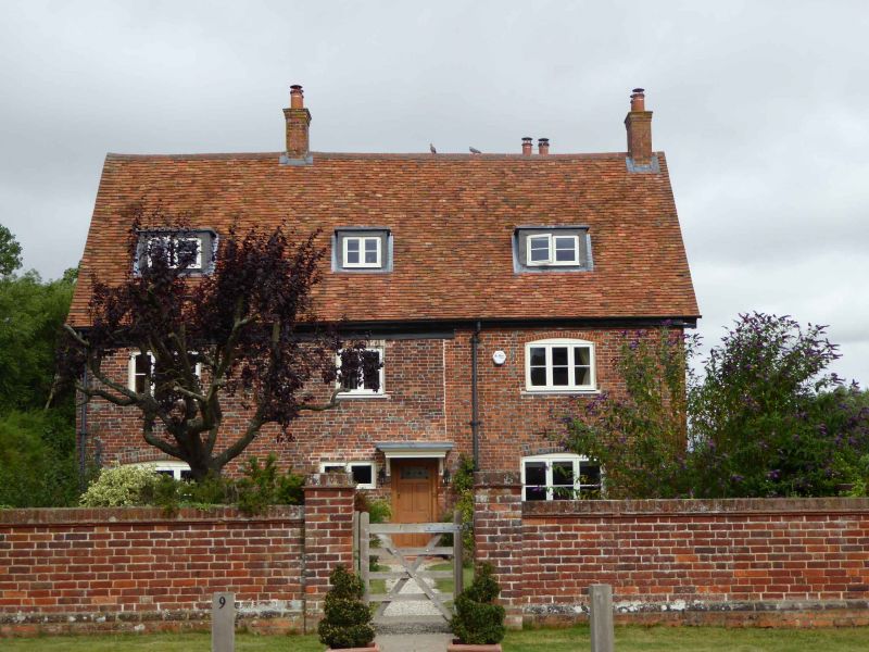
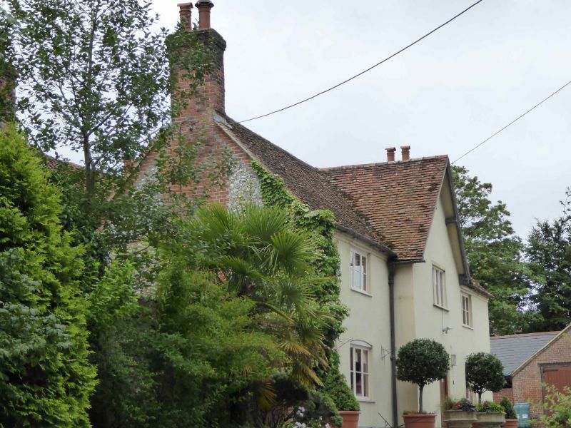
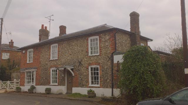
Parsonage or Church Farm Farmhouse with perhaps later 16thC core, cased in Brick and partly rebuilt in later 18thC; some 20thC rebuilding & additions.
Exterior: Brick-cased, South-east facing Building of 3-Front Bays & 2-Storeys, with Dormer windows lighting converted Attics. The Brick Casing to the Front is typical of the area in that it exhibits the decorative use of Blue Headers; it is of 2-Phases, probably fairly close in date and of the later 18thC. The left-hand 2-Bays are the older, the Brickwork irregularly bonded with reddish Bricks with dark Blue Headers. This is a Refronting, later in date than the narrow-Bricked Gable Wall to the left which is probably of the late 17thC or early 18thC (projecting early 20thC Ground-Floor window Bay not of interest). The right-hand Front Bay is of a more Orangey Brick, in a regular Flemish Bond with Blue Brick Headers producing a Chequered pattern. This probably represents a rebuilding of this end of the Property (shown with an end-Jetty on an illustration of 1764), extending to include a short, integral, Single-Storey Range to the rear. Front Door to the centre (immediately against the right edge of the older 2-Bays); 20thC Brick Porch (not of interest). The windows give an approximate symmetry to the Front: 3-light Casements to the end Bays (those to the Ground Floor slightly longer than those above) with a small 2-light Casement to the centre of the 1st-Floor, and a small pair of 4-pane Casements to the left of the Front Door lighting the Staircase within. Most of the windows have been renewed. To the rear-right a large external Chimney Stack with Flint & Stone lower part & Brick above is recognisably that shown on the illustration of 1764. A similar (but presumably rebuilt) Chimney rises from the rear-left. 20thC Brick Lean-tos against the Rear of the House and against the c.1800 Rear Range are not of interest, nor is the 20thC Brick extension. The Roof is of Red Tile, relaid when the Roof was partly replaced in the early-20thC; 2-Brick Stacks of this date rise from the centre of the older 2-Bays and from the right-hand Gable.
Interior: The Front Door opens into a Hall which extends the full depth of the Property, and which extends left of the Door (as entered) where a simple Staircase of c.1800 leads off at Right-angles against the Outside Wall. Front Room with Kitchen behind in right-hand Bay; Dining Room in left-hand Bay; and small Office in Centre Bay with Bathroom behind. Upstairs the Plan is roughly replicated, and there are some surviving Planked Doors, perhaps 18thC. There is also a curved Brace visible in the centre-rear 1st-Floor Bedroom relating to the possible Crown Post Roof above. The Staircase continues to the Attic Floor with a Bedroom in each end Bay (only that to the right with Fireplace) and a Storeroom to the Centre. The Attic Rooms are set within the probably later-16thC Roof; this survives largely intact in the older 2-Bays with Tie Beams, Collars & Common Rafters (and thus possibly of Crown-post type), as seen most clearly in the closed Attic Space over the Collars. Over the newer Bay is a replacement Roof of the early-20thC.
History: Church Farm is identified by the VCH as the Rectory Farm, the Living being in the possession of All Souls College from 1440. It was therefore either the College, or its Tenants by Agreement, which successively Built & re-Built the Farmhouse. The Church Farm Complex stands immediately West of St Margaret’s Church (Listed Grade I) on the North edge of Lewknor. The Complex includes, on its East edge, a Grade-I Listed Building, a mid-14thC Aisled House which was later converted to a Barn.
Town Farmhouse & Attached Wall: Farmhouse. Early/mid 16thC, extended to sides c.1790. Originally Timber-framed. Rendered Front: sides & rear of Flint rubble with Brick Dressings. Gabled M-shaped old Tile Roof; Brick symmetrical End Stacks and large Rear lateral Stacks. Double-depth Plan. 2-Storeys; symmetrical 3-window Range. Central Gabled projecting Bay has 20thC Leaded window over Segmental Arched 20thC Door: Flanking Bays had 3-light leaded Casements except 19thC 3-light Casement to lower left. One-storey Brewhouse to Right of Flint Rubble with Brick Dressings, Gabled old Tile Roof, and 18thC Plank Door flanked by 3-light leaded casements.
Interior: 16thC House in Centre has exposed Timber-Framing & 3-Bay Queen-post Roof with curved Windbraces & Clasped Purlins.
Subsidiary Features: L-shaped Wall to left of Front, of Flint & Rubble with vertical Brick Dressings.
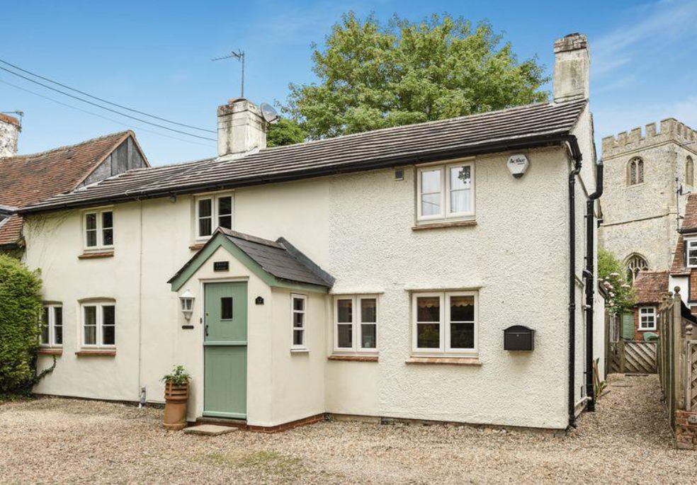
3-Bedroom Period Cottage by the Village Church. This attractive 18thC Cottage occupies a quiet setting in the Middle of the Village with an outlook to the 12thC Parish Church. To the Rear is a split-level Cottage Garden with Stone Terrace & shaped Lawn. In recent years the Cottage has been remodelled & refitted but it still retains the features of it’s 18thC Origin. There are Timber Beams, Oak Floors and an exposed Brick lined Fireplace with multi-Fuel Stove. A Reception Hall forms the core of the Cottage, off which is a large Family Kitchen/Dining Room and a double Reception Room with Fireplace, Oak Floor & French Doors to the Garden. It is a large Room with a Range of painted wood Cabinets and a Fireplace housing an Oil Fired ‘Sandyford’ traditional Range Cooker that also Services the hot water & central heating. There are 3-double Bedrooms on the 1st-Floor with a Bathroom. To the rear, a Stone Paved Terrace extends from the rear of the Cottage with raised herbaceous borders & a small Store.
Small Cottage. Early 19thC. Front of Flemish bond Brick with flared headers; sides and rear of light Timber Framing with Brick infill. Hipped old Tile Roof; Brick end external Stack. One-unit Plan. 2-Storeys; symmetrical 2-window Range. 20thC Weatherboarded Porch. Segmental Arches over 2-light Casement left of Porch and early-19thC 2-light 1st-Floor Casements.
Interior: not inspected.
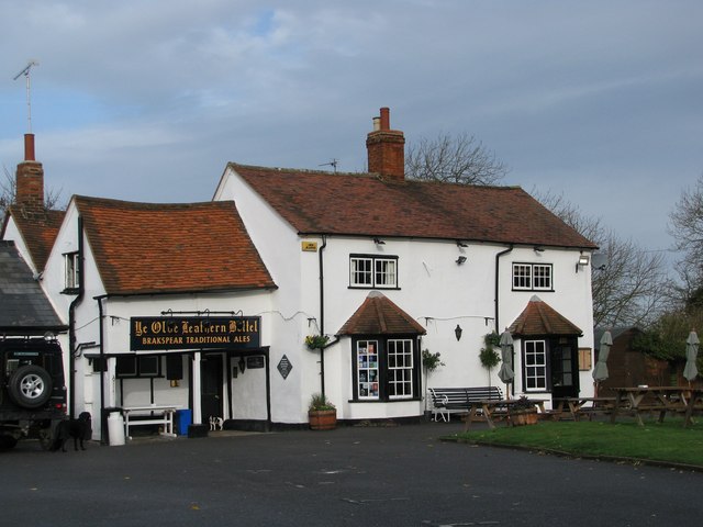
The Vicarage, in which the Vicar or his Curate Resided down to the 18thC, presented a contrast to these Gentlemen’s Houses. A Land Terrier of 1685 describes it as ‘an Ancient Dwelling House, built almost in the form of a Roman H, only a Storey & a half high’. With its Stable, Small Outhouse, 2 Courts, Garden, Well-yard & Rick-yard, it probably did not differ greatly in appearance from the Yeomen’s Houses which, with a few Farmsteads (of which the Lord of the Manor’s Town Farm and the Rector’s Church Farm were the Chief), some Cottages, a Smithy & the Inn called the ‘Leatherne Bottel‘, at that time made up the Village of Lewknor. The ‘Leather Bottle‘ has been added to & modernised, but remains substantially a 16th to 17thC Timber-framed House with Brick Filling.
‘Sheet 047’, in OS Map of Oxfordshire 1882-1887
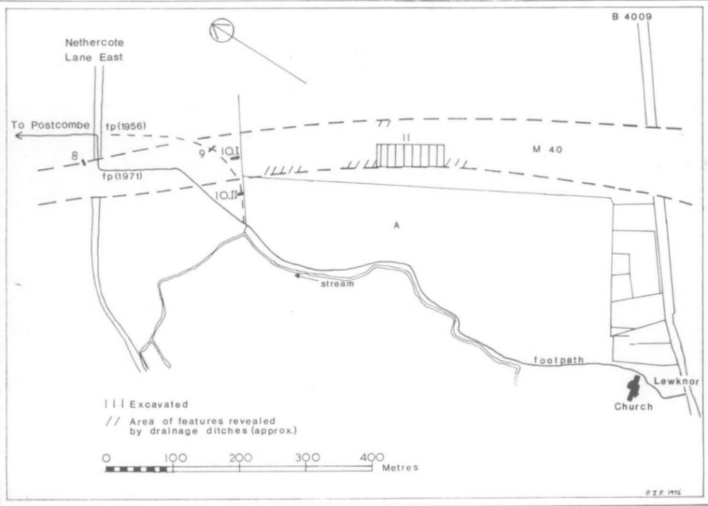
At Lewknor Prehistoric Activity and a substantial Romano-British Settlement, of indeterminate Status, have been Located in 1971/2. The ‘Farmstead‘ is apparently surrounded on its North, East & possibly South sides by Boundary Ditches, and on the West by a small fast-flowing Stream, Springing from the Foot of the Chilterns, and providing an adequate Water Supply. The nucleus of the Settlement seems to be in Field–A (Centre). Fortunately the M40 Motorway then being Constructed only clipped the Extremities of the Settlement, the Buildings in Field-A remaining relatively intact for future Investigation at a more leisurely pace than was possible in May 1972. The possibility of Medieval occupation in the immediate vicinity must be borne in mind.

Ditch-1 – lying outside Ditch-2 was aligned East-West for some 49M before turning 90° to run North-South for 9M where it turned through 45° to run North-East- South-West for 39M, cutting obliquely through the Eastend of Ditch-2 – before joining Ditch-3 and turning a further 90°. It was cut into the natural Bedrock to a depth varying between 350 & 600mm and varied in width in the Bedrock between 1.3 & 1·6M. It was filled with a dark brown Loam containing many Chalk & Greensand particles & quite large quantities of Pottery & Animal Bone. The bulk of the Pottery & all the Coins were in the Upper Level, and s0 this Ditch was Silted up by c.340-350AD. The time of its Construction cannot be dated. There is no apparent purpose for the abrupt changes in alignment of this Ditch, but in the Corner formed by the 1st right-angled turn was an Elliptical Pit, F2, with straight sides & a flat bottom, filled with dark brown Soil containing Flint, Chalk & Greensand particles. It measured 1.20M x 0.9M & was 150-250**mm deep. It contained a few animal Bones and a few shards of Romano-British Pottery of indeterminate date.
Ditch-2 – This 1st Ditch on the Site was aligned North-West-South-East. It was filled with a medium brown clayey Loam. This Ditch was revealed for some 28M, the Western end fading out. The Eastern was Butt-ended. and it is quite likely that the Western end may not have been Dug originally into the Bedrock. The Pottery indicates a 2ndC date.
Ditch-3 – started some 600-mm East of the end of Ditch-2 aligned at an angle of 80° to the latter Ditch. It was Dug 260-320mm into the natural Bedrock with sloping sides & a flat bottom, 880-mm wide at the top & 320-mm. wide at the bottom, filled with a dark brown Soil containing many Chalk & Greensand Particles. Insufficient Pottery was recovered to date Ditch-3 closely.
Ditch-4 – This Ditch, cutting Ditch-1 in its lowest Levels, ran approximately at rightangles to all the other Linear features on the Site. A length of 31M was exposed. It had a round profile, and was cut into Bedrock to a depth of 360-400-mm and was 900-mm wide at its highest excavated Level. It was filled with a dark brown Loam, containing many Chalk & Greeruand particles. Little Pottery was found, but it was of 4thC date.
Map of the County of Oxford, from Actual Survey, by A Bryant, in the year 1823. Inscribed by permission to the Right Honourable the Earl of Macclesfield, Lord Lieutenant, and to the Nobility, Clergy & Gentry of the County.
Lewknor Map Dated 1598 by Cartographer Thomas Langdon
Public Rights of Way Round Lewknor
Reproduced from VCH Oxfordshire, available at British History Online
